Pages

Friday, March 27, 2020

Llano, a Socialist Failure

Robbyn, a fan of local history contacted us and described a place to visit that she had heard about through family stories. After a few more historical tidbits from Robbyn, we discovered those family legends were indeed based on historical facts.

 As with all stories – let’s start at the beginning.

At fifty-five years of age, Job Harriman had had it with his law practice and his political aspirations. The defeated California candidate for governor with the Socialist Labor Party in 1898, and the defeated Vice-Presidential candidate for the United States with the Democratic Socialist Party in 1900, and twice defeated for mayor of Los Angeles, Harriman knew a change of scenery was needed.
So, in 1913, the avowed socialist decided he could build a community where all worked together, to make a better tomorrow.

He lost that race, as well as all others
According the to the book, Two Hundred Years of American Communes (Yaacov Oved, 1987), Harriman was quoted, “It became apparent to me, that people would never abandon their means of livelihood, good or bad, capitalistic or otherwise, until other methods were developed which would promise advantages at least as good as those by which they were living.”
 
And who wouldn’t like those sort of promises?

What Harriman needed was a place to put down roots for his desire of everyone living in harmony with each other, without disagreements or turmoil.

Hmmm, most people can’t get two hours of that at a family Thanksgiving dinner.


Anyway, that paradise was approximately 45 miles northeast of the city of Los Angeles, in the Antelope Valley. Utopia had been waiting for a visionary and Harriman was that dreamer, thus, his socialist enclave would become a reality on May 1st, 1914.

But first Harriman needed money to purchase the nearly 9,000 acres in the unincorporated area of Los Angeles County, in the town of Llano.

This is where his friend and socialist banker, Gentry P. McCorkle, from the city of Corona, came into play. Socialist banker? That seems like an oxymoron. But in the book, Bread and Hyacinths: The Rise and Fall of Utopian Los Angeles (Paul Greenstein, etal, 1992), Harriman is quoted as proposing his dream to McCorkle, “If you join me and a few other of my friends, we will build a city and make homes for many a homeless family. We will show the world a trick they do not know, which is how to live without war or interest in money or rent on land or profiteering in any manner.”

McCorkle was in, and Llano del Rio was soon up and running. Of course, being in the High Desert, there was a need for water, but Harriman and McCorkle had also purchased the water rights from the Mescal Land and Water Company, which had control over most of the water from Big Rock Creek. This stream, active for much of the year, got its water from the San Gabriel Mountains to the south and should be plenty to sustain a thriving colony. Or so they assumed.

In Harriman’s magazine, The Western Comrade, large advertisements went nationwide inviting like-minded individuals to this sparsely populated but beautiful location in Southern California. He touted how the land would be a bountiful mecca for all sorts of agricultural products.

There were some catches before a person could become a member of the commune – and, isn’t there always a catch in paradise?

First, a person had to believe in the tenets of socialism. Second, the person had to have three socialist references. Third, you had to purchase two thousand shares of the Llano del Rio Company at a dollar a share. And fourth, you had to be Caucasian – won’t touch that last requirement here. 

Rules? Comrade Beyer says, we don't need no stinking rules
Of course, Llano del Rio promised a living wage of four dollars per day for labor – that was a good deal higher pay than normal for that time. But, if a person didn’t have the money for the shares, they were allowed to purchase three-quarters on credit to the company.
Simple math, one dollar a day to the loan debt, the other daily amount for living expenses provided by the company, and the leftover of an individual wages went into a general account for the community. At times of surplus, all would share in the profits from the combined work.
Turned out, there never seemed to be much of a surplus at all.

I paid a dollar a day, and didn't even get a roof over my head
People started arriving from around the country, and in the first year, over 150 people lived in Llano del Rio. Most lived in tents with their families, but soon stone structures started to appear.  The comrades built stone meeting halls, dormitories, and even a small hotel, among other buildings, making the area a real community. Rather a laudable accomplishment. By the beginning of 1917, nearly 1,100 people resided at Llano del Rio. But as with many dreams, this one of Harriman’s didn’t quite pan out.

Distrust and accusations started erupting at Llano del Rio between various group members. Some like the Brush Gang, who had private meetings outside (thus the name), complained the board of directors treated themselves better than the rest of the community. True or not, mistrust creeped in.
It seemed, to paraphrase George Orwell, all comrades were equal but some comrades were more equal than others.

By the end of 1917, most members had moved away and in 1918, Llano del Rio filed bankruptcy. Many of the original members, including Harriman had relocated to New Llano, in Louisiana to start over at the end of 1917. That dream also ended in 1937.

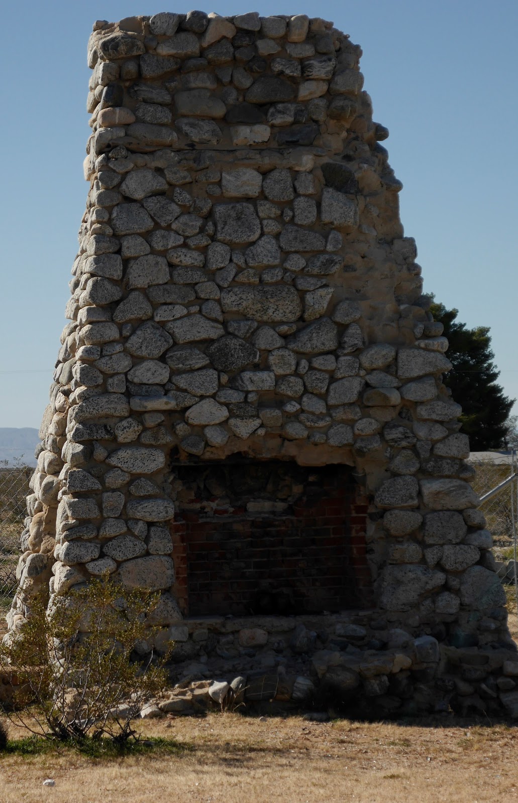
The dream kind of went up in smoke
As we walked among the ruins of Llano del Rio, Laureen and I met a couple from Los Angeles, Chris and Joanne, who were also visiting the site. Chris had explored the area by motorcycle quite often and always wondered what the story behind all the stone remains were.

Remaining walls for community quarters
“So much history and so close to home.”

We agreed. It’s interesting to walk among the concrete and rock remains of what was once touted as a community for all and which in reality became a community for none.

Friday, March 13, 2020

St. Francis Dam disaster

 A reader by the name of Kendall, wrote to us and asked if we had ever heard of the St. Francis dam disaster.

No, we had not, and told him so.

“You should look into it. I think you’ll find it interesting.”

We did, and learned he was right. It was not only interesting, but the details described a horrifying moment in history that occurred about an hour and a half’s drive west from Victorville.


About noon on March 12th, 1928, the Bureau of Water Works and Supply Superintendent, William Mulholland, along with his assistant, Harvey van Norman, was checking on the St. Francis Dam, located approximately forty miles north-east of the city of Los Angeles.  Mulholland had received a call from the dam keeper, Tony Harnichfeger, that there appeared to be seepage issues. Mulholland, along with van Norman, inspected the dam and concluded that the seepage was normal.

Twelve hours later, Harnichfeger, along with Leona Johnson, again inspected the dam. That was when the unthinkable happened. The entire northern side of the dam collapsed, spewing 12.5 billion gallons of water through the San Francisquito Canyon.

The initial waves from the collapse were nearly 120 feet high. Within minutes, the dam keeper’s house was destroyed and all his family were killed. Neither Harnichfeger nor his six-year-old son, Coder, have ever been found.

Within minutes, the waters struck Powerhouse #2, killing 64 workmen and their families living nearby.

The waters raced down the canyon at incredible speeds, reaching Castaic Junction with 55 foot waves. The small town was washed away.

Much more destruction and loss of life followed as the seemingly never-ending torrent of water struck the towns of Fillmore, Bardsale, and Santa Paula.

When the five-foot waves finally crashed into the Pacific Ocean, fifty miles south of Ventura, the loss of life was over 450 people. The exact number of humans lost will never be known. There were groups of iterant workers living in the canyon at the time as well as others looking for work camping out of doors in other areas where the waters tumbled.

Bodies of some victims were found days, weeks, and even months later, some as far away as the Mexican border. In fact, in 1992, the remains of a victim were found buried deep in the earth near Newhall. Many have never been found.

The St. Francis Dam disaster of 1928, is the second largest loss of life disaster in California history – only the 1906 San Francisco earthquake took more lives.

We researched the St. Francis dam disaster and knew a trip there was absolutely needed. So, we headed west on Highway 138, with our buddy Paul, past the towns of Littlerock, Pearblossom, and Palmdale.

The drive was beautiful. Once past Palmdale, the scenery turned idyllic with green rolling hills and large trees hugging the roadway. It was ironic to witness all the life swishing past the windows on the way to a canyon of such deep sadness.

We weren't sure what we would find at the site of the former dam. In 1929, the remaining sections of the dam which had remained standing were dynamited, bulldozed, and jackhammered to pieces. This was done to keep the curiosity seekers from spilling over the area for macabre souvenirs.

Large pieces of concrete from the dam litter the valley


Using a drone for aerial shots of the disaster scene
Upon arriving, the sun was bright and the birds were singing. It’s a pleasant place, this site of the St. Francis Dam disaster. There are trees and bushes alongside a small but steady gurgling stream, in the San Francisquito Canyon. A comfortable walk down an abandoned road leads to what remains of the dam.

Beautiful walk toward a past human disaster
The area is just beautiful and sad at the same time
The first observation is that it is just a canyon. Pretty, but just a canyon. Then atop a ridge, remains of concrete with steel cables can be seen. Nearby, are massive sections of concrete strewn across the canyon floor. One such block of cement can be seen about a quarter mile west of where the dam collapsed, it stands at 30 feet high, 54 feet wide, and 63 feet long – that is one big hunk of concrete, which explains the power of the water rushing out from the dam.

Just one large piece of concrete torn loose from the dam during the disaster
Further down the canyon, there are two crosses in memorial to those who perished back in 1928. On one it is written, May they find peace in this place of hoo doo.  A place that brings bad luck, that is all that needed to be said.

A touching memorial for the victims of the dam disaster
We met a young hiker, Chris Hertzberg, who knew the history of the dam. Chris happened to be an engineer, so he’s a pretty smart guy when it comes to building things.

“What was the reason for the dam collapsing?” I asked.

 “Lots of ideas were floated around, but I think the main one was that after the dam broke, and the investigation began, it was discovered that there had been an ancient landslide where a portion of the dam was built. They didn’t have the technology back then to know that,” he said.

John talking with Chris Hertzberg
He pointed out the red earth and it seemed obvious to our modern eyes that yes, there had indeed been a landslide. But in 1928, they didn’t recognize such things. Modern dam-building has come a long way. And Mulholland was a self-taught engineer. There were things he didn’t know, and things he couldn’t know in that era, given the limitations of the time. And this was the sad result.

“Different engineers must to be involved in these things to ensure everything is correct. Research must be thorough and complete,” Hertzberg stated. “Can’t leave it up to one, self-taught engineer like Mulholland.”

In an effort to prevent such a disaster from happening again, in 1929, the California legislature enacted a new law, that any non-federal dams had to be inspected by the state. Prior to that, any municipality could build a dam with no input from the state.

The site is beautiful, sad and peaceful. The lives lost deserve to be remembered. Consider stopping by this historical site.

For directions:
https://scvhistory.com/scvhistory/st-francis-directions.htm