Pages

Showing posts with label Kit Carson. Show all posts

Thursday, January 9, 2020

San Pasqual Battlefield

Stained glass - depicting charge by the Dragoons
One of the habits Laureen has when we travel, and I believe everyone should, is using her phone to search for any interesting sites near us when we stop. No matter where we are, there always seems to be someplace we haven’t visited, or in this case, never even knew existed.

After visiting friends in San Diego recently, we stopped in Escondido for fuel. While at the pump, Laureen delved into her habit and asked me, “Did you know that a battle was fought near us, during the Mexican-American war?”

“Nope,” I hadn’t heard of it before – sad for a guy who’s lived in Southern California most of his life. “Where?”

“Five miles east down Highway 78.”

Enough said. Fueled and ready for a new adventure.

A new adventure - count us in!
The San Pasqual Battlefield, now a State Historic Park, is located one mile east, past the entrance to the San Diego Zoo Safari Park – formerly, the San Diego Wild Life Animal Park, on Highway 78.
A very informative gentleman who works at the state park, Ranger Gil, was a font of knowledge concerning the history of the San Pasqual Valley. He actually informed us that he wasn’t actually a ranger, but an aide at the park.

Gil, regaled us on every moment of the battle, but ended up with a rather poetic take on the entire war itself.

“You know, many people don’t talk about the Mexican-American War in school, and certainly not this battle. It’s a chapter in both our histories that don’t put us in any positive light. It really was a battle of greed and power, from both sides of the border. There really were no clear winners – especially here on this battlefield.”

Turns out, when walking through the museum at the state park, one could see how both sides, at least here, made many strategic mistakes and lives were lost. The Californios had made enemies of the local natives, the Kumeyaay (also known as the Ipai), who then sided with the Americans, giving them aide and assistance when needed. And the Americans believed they could easily overcome the Californios, and made many tactical mistakes – too many to discuss here.

View of the main battlefield from the Visitor's Center
“Both sides claimed victory,” Ranger Gil stated. “The Americans lost more men in the battle, but very soon after, Pico and the Californios were forced to capitulate on January 10, 1847 to the American forces. This ended the fighting in California.” 

Fascinating but truly sad, that the bloodiest military action in California, during the war between the United States and Mexico, occurred near the city of Escondido.

Turns out, in December of 1846, General Stephen W. Kearny was traveling through an area north of San Diego and east of what would become Escondido, to bring battle against a group of Californios (people of Hispanic descent, still living in California after Mexico’s War of Independence from Spain) under the command of Captain Andres Pico. On President Polk’s orders, these loyalists to Mexico needed to be removed from California at all costs.

Unfortunately, that cost was twenty-two American soldiers of the First Dragoons and a half dozen of the Californios. The weather was damp, so the powder to fire muskets was wet and wouldn’t fire, leaving Kearny’s men to fight hand to hand combat with the Californios. The American soldiers stood no chance, with only swords and non-functioning muskets, as the Californios were armed with long lances which could kill an enemy yards away in battle, as well as lariats which could easily capture or make an enemy combatant ineffective.

As we looked out the large glass windows, which allowed visitors a panoramic view of the battlefield. It was hard to digest how death came so easily in such a beautiful valley. It had. And, though we could read the informative descriptions about the battle and reasons for the battle, it just didn’t make the reality any better.

Plaque commemorating the San Pasqual Battle
Less than a hundred yards from where we stood, men had fought and died during the cold and wet days of December, 154 years ago.

Plaque naming the Americans killed in action
On the way out of the museum, we said our thanks to Ranger Gil, who stopped us and told us of another location worth looking into.

“After this, it’s always nice to have something fun to visit," he stated. He was right.

Kit Carson, the famous frontier scout, had been with Kearny during the engagement, and there is the Kit Carson Park and Amphitheater, located in Escondido, right off Highway 15.  This 285 acre city park, has it all for any outdoors-person, including the only American sculpture park by the late, international artist, Niki de Saint Phalle. This garden of sculptures was Phalle’s way of depicting California’s mythic, historic and cultural roots.

Part of the garden sculptures
Unfortunately, the garden sculpture was closed when we went to view it. But, from looking through the fence – not in a creepy way – we were able to see marvelous and colorful sculptures created by a visionary mind.

It definitely requires a re-visit, to be able to walk among the huge imaginative creatures molded by Phalle.

So, when out of town, check around for places nearby worth seeing – we know there are plenty.


For further information:

https://www.parks.ca.gov/?page_id=655
https://www.escondido.org/queen-califias-magical-circle.aspx

Sunday, June 19, 2016

Mojave Road Saga - Day 1

Note to self: before venturing forth on the historic Mojave Road start early and get plenty of sleep the night before. A single lane dirt road (path in most instances) heading west (from where we started) for nearly 140 miles should not be started in the afternoon or after a lousy night sleep.


Hope self reads note!

He didn't - as with many travelers the night before an adventure starts, the sleep is fitful with the brain working on overload. Are we forgetting anything, is there enough fuel, enough water, should we be traveling this road with only one vehicle? Questions like these, and many more, often keep the explorer from getting the right amount of sleep before a trip begins. Starting tired is one strike against a trip along the Mojave Road.

Starting at nearly two in the afternoon is the second strike.

Luckily there wasn't a third or this trip would have been a strike out.

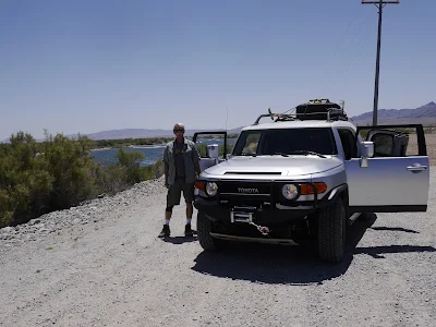
John and Paul just wanted to get started down the dirt road leading from the Colorado River - so in the heat of the day and with tired minds they drove out of the Avi Resort looking for the beginning of the Mojave Road.


It may get a bit hot in the Mojave Desert - maybe!

Perhaps that's why it took nearly an hour to find the beginning.

For most of the trip, the GPS was right on. The rock markers called cairns (stones set up in a pyramid fashion) were easily found, and the map in Dennis Casebier's book, Mojave Road Guide, pointed us in the right direction. But for some reason it took some maneuvering and back tracking to locate the beginning of the road.


A 'cairn' - guideposts for the Mojave Road. Don't miss them!!!
The trip began at the site of Fort Mojave which was built around 1859 on the shores of the Colorado River. The fort had been built to maintain a sort of peace with the Mohave Indian tribe which had been causing some grief - like killing immigrants and explorers who ventured into their lands. For all but two years during the Civil War, the fort was manned until 1890 when it was turned into a school for the Indians until the 1930s. Nothing much is left of the site - in truth, we found nothing indicating a previous Army fort from the 19th century. No cannons, rifles, graveyards, placards, markers, or anything else indicating a fort had been built along this part of the river.

 Of course, to be fair we may have missed a turn here or there but one thing was certain - the sand was extremely soft, the temperature HOT and we wanted to get a move on westward.


Deep - very deep sand - 4 x 4's only please


No fort, just riverfront property.


For some reason it took some maneuvering and back tracking to locate the actual beginning of the Mojave Road. Trails were everywhere heading into the desert west of the Avi Resort and though the guidebook was explicit we could not find a cairn to save our lives. One road went west and then south and then east - another road went north and then west and then east - we guessed all roads ended back at the Avi Resort. 

It may have been a trick to force us to lay by the cool blue river and gamble. But the ploy didn't work and in about an hour we finally found the beginning of the Mojave Road.


By trial and error we eventually found the road
We found it and the adventure was on. And what an adventure!

Across the same road that the likes of Jedediah Smith, Kit Carson, John Fremont, and Peter Skene Ogden had used while making their way across the Mojave Desert, we were traveling with the ghosts of some of the most famous early American adventurers there were.

Nothing could stop us now - almost nothing . . .


This something did stop our westward movement the first day.
In a relatively recent rain - something the deserts don't often get but when they do it pours and takes out primitive stretches of road easily. This was the case a few hours from the kickoff point of the trip. Even four wheel drives could not make it across a section of the upcoming road since what we learned electrical cables may be exposed or something to that effect. Whatever we would have to find an alternate route - one of 34 miles set up by the BLM or a 14 miler by a great group of Mojave Road enthusiasts.

We'd sleep on it and decide in the morning - tired and hungry we made camp a quarter a mile away and enjoyed the solitude of the desert. We made plans to start fresh and early the next morning.

Stay with us -- the adventure continues with next week's blog entry.

Monday, March 14, 2016

Does a Sidewalk End in Reality?


 Does a Sidewalk End in Reality?
Howdy Pardner!

Old Town Scottsdale is a pleasant adventure for anyone – no matter your age. Restaurants, gift shops, pubs, and just a meandering sidewalk beckon the traveler to take a moment, step out of the automobile and let the feet lead the way.

No hurry while putting one foot in front of the other but simply pure enjoyment while sightseeing.

Sightseeing – hmmm, “n, the visiting of places of interest” per Webster and doesn’t that say a lot of what researchers and explorers do on a daily routine? To research this or that and then go out and physically explore to learn if that research was valid or not. To take a walk-about as the Aussie’s like to remind us is a way to reinvent ourselves – to learn about others as well.

Reinvent yourself - that's not our Happy Hour idea

While treading about the curved sidewalks of Scottsdale the visitor can’t help but notice interesting (there’s Webster) historical notices etched into the very cement below one’s feet. It is as though the sidewalk of Old Town is leading the visitor through some very important episodes of this city which was incorporated back in 1951 with a population of 2,000 but now boasts over 230,000. The cities own slogan is, “The West’s Most Western Town”. Of course, many towns and cities would probably argue that like Tucson, Tombstone, and even Los Angeles (thought we’d throw that in) but the history of Scottsdale is rich.

The Most Western of Western Towns?

The town was named after Winfield Scott – not the famous General of the Civil War but the other Winfield Scott of the Civil War (confused yet?) who served as a Chaplain but did lead Company C of the 126th New York Volunteers. Even being a fire and brimstone Baptist minister Scott knew his country – the North – needed his skills and so with the rank of Captain he led his men into many dangerous fights with the Confederate States Army. Being wounded at the Battle of Harpers Ferry, Gettysburg and finally Spotsylvania Court House Captain Scott was released from duty due to his wounds toward the end of 1864. He and his family moved a bit after the war and ended up in the west in the Salt River Valley, east of Phoenix. Winfield was so impressed he settled and started promoting the area as a wonderful place to embrace – thus the reason in in 1894 the area become known as Scottsdale.
Winfield and Helen Scott in 1900

It should be noted that in 1888 Winfield bought 640 acres in the Salt River Valley for the price of just over three dollars - that is the whopping amount of ninety-two dollars in 2016. A square mile of land for less than a foo-foo coffee at Starbucks. A good investment for the Civil War Vet and to have the town named after you too - such a deal! 

Now, the sidewalks visitors will find themselves walking atop of don’t have much in the way of describing Captain Winfield Scott or the ‘Fighting Pastor’ as the founder of Scottsdale but it does lead the curious on who actually did have something to make Scottsdale the most western of western towns.

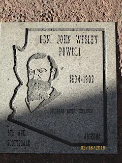
Billy the Kid, Bat Masterson, Wyatt Earp and many others are etched right there in the cement reminding those staring down that very famous western characters once roamed through these parts. Fascinating bit of history but that is not all there is to Old Town.

Zane Grey -  Western Writer

Doc Holiday -  Western Dentist

General Powell - Western Explorer


Kit Carson - Western Scout


A river runs through the western edge allowing the traveler a chance to feel cool and refreshed – that’s what water does for a person. Restaurants line the river-walk and along the long stretches of sidewalk stores tease the shoppers to enter and purchase everything from tourist gizmos to hand made furniture in the thousands of dollars and to some of the most marvelous jewelry available.

Time for an evening stroll along the riverfront
In 1974 Shel Silverstein’s poem, ‘Where the sidewalk ends’ was published to international acclaim and one line in particular meant something special to J and L – “Yes we’ll walk with a walk that is measured and slow.”

Don't want to miss anything along the way you may regret
That is how one should take walking down a sidewalk – measure steps to ensure nothing is missed and slow enough to enjoy those things not missed.

These two fellas are taking it real easy and slow