Pages

Showing posts with label Route 66. Show all posts

Thursday, September 26, 2024

The Rebirth of the Ghost Town of Amboy

Welcome to Amboy, CA
According to Ken Large, Operations and Logistics Manager for Roy’s Motel and Cafe in Amboy, there are ongoing plans to rejuvenate this once prospering town into something for the future.

“When Albert passed away in 2023,” Ken said, “I wondered what would become of his dream of turning this once vibrant town into a go-to destination for those traveling along Route 66.”

Albert Okura, the founder of the popular restaurant chain Juan Pollo in Southern California, had purchased the nearly forgotten town of Amboy in 2005. Albert loved history, especially the history of Southern California and more importantly Route 66. When he purchased the town of Amboy, his wish was to do all he could to turn it back into the iconic spot where travelers from across the United States would stop along America’s Highway during its heyday.

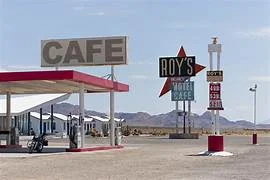
The original sign is lit up nightly in Amboy, CA
He had big plans, but that was nothing unusual for this man who created a chain of cookeries which would later label him the Chicken Man for the delicious food served in his nearly 30 various locations.

Albert knew he could recreate the thrill of travelers along Route 66 that was once felt after the route was completed in 1926. Sadly, Albert passed away on January 27, 2023 at the young age of 72 in Ontario, California. 

But, his dream did not die. “His family have been wonderful in keeping Albert’s dreams alive here in Amboy,” Ken said. “Take a walk around and see for yourself all the construction being conducted to complete this place by the summer of 2026.”

That summer would be the 100th anniversary of the completion of Route 66, and there are huge plans being developed along that long river of asphalt stretching from Chicago all the way to Santa Monica.”

Rumor has it that a family of Sasquatches may attend the festivities somewhere along the nearly 2,500 mile highway - but of course, that is on a need-to-know-basis.

And, I need to know!

Before I started walking the property, Ken did inform me that finishing the entire project may be a bit of a stretch but “...knowing Albert’s family as I do, I think we may indeed have everything up and running for the huge crowds that will be coming through. They are an awesome group of folks and I am sure keeping Albert’s legacy alive will be in the forefront of their thoughts.”

I’ve been through Amboy more times than I can count - either heading east or heading west. Did I stop each time? No, but every time I passed by those stark white empty cabins, the large paned windowed reception area of the motel, and the gas station with its huge sign out front welcoming visitors, I felt a slight tug at my heart.

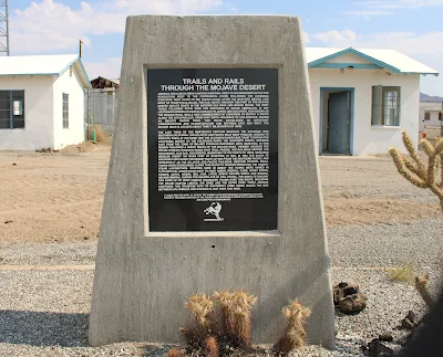
Road monument with unfished cabins in the rear at Amboy, CA
Amboy, once a bustling and hustling railroad stop for miners, travelers, shippers, receivers, and those that just wanted an adventure which then, as many such towns did, turned into a ghost town and was now being brought back to life, makes me smile.

The last time I visited and spoke with Ken, a large tour bus had just pulled up and about a million tourists exited. It was a very large custom made bus.

“We sometimes get up to three thousand people visiting a day,” he said. I just saw a million, so I suppose his math could be accurate, rounded off for the year.

As I was taking a snap of some of the construction going on, a tourist walked to me and in a very German accent and said he recognized me.

“Yes, I am John R. Beyer, the world-renowned travel writer,” I humbly responded.

“Nein,” he retorted. “You look like the restroom attendant. Paper is needed in stall three.”

I nodded and then mumbled, “You probably meant number two.”

Ken advised me that 50% of the visitors are European, 35% from the United States, 10% from South and Central America and the remainder from Asia or perhaps the territory of Nauru.

As I wandered here and there, teams of construction personnel were wiring this, harnessing that, and pretty much doing what construction personnel did. They were busy rebuilding Amboy into what Albert Okura had imagined.

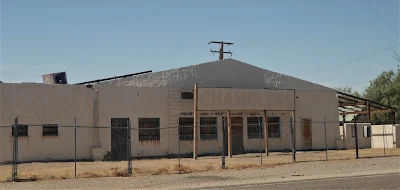
New construction in the works in Amboy, CA
A town full of life which invited the tourist to stop for a spell for a rest, and perhaps a meal and then back onto the historic byway or Route 66.

In fact, in keeping to Albert’s plans, Ken explained that they hoped to have rooms ready to rent, a fully functioning restaurant, and other amenities which made staying in Amboy for more than a couple of hours a reality.

I asked about the family and their thoughts about Albert’s visions.

“I must say that Kyle, one of Albert’s children, comes here quite often and spends long weekends checking out how much work is getting done. Often, Mrs. Okura and other family members accompany him and they love it out here. They are a great and loving family.”

Years ago, my lovely wife Laureen, along with one of our daughters, Kelly, drove through Amboy and were delighted to see the site was being used as a Fly- In. Planes of all makes and models were actually landing along Route 66 and taxing to the small airport located there.

Music, food, and other entertainment were in abundance for all to share in.

Other events which are being coordinated by Ken, the other staff members, and the family are motorcycle rendezvous, classic car shows, airplane fly-ins, music festivals, space alien conventions, and the list goes on and on.

And gas is available at the original pumps
“We also are also a venue for those who want to rent the place out for movie shoots, television ads, music videos, weddings, and the like,” Ken stated.

Recently a Polish singer by the name of Daria Zawailaow utilized the town for a music video. It is spunky, riveting, and I have no idea what she is singing about - my Polish is rather limited except for some old and now inappropriate jokes.

The below link will show just one of the musical talents who visited Amboy and wanted to share with their audiences what an iconic place this little town is and why it is important to visit.

https://www.youtube.com/watch?app=desktop&v=CoMFkWwevjA

For more information: https://visitamboy.com/ 

John can be contacted at; beyersbyways@gmail.com


Wednesday, August 18, 2021

Oro Grande, a great little town

Welcome to Oro Grande

A friend of ours, Kathleen, contacted me and said I needed to meet the mayor of Oro Grande. I didn’t even know there was a mayor.

“They have a mayor?”

 “Well, he’s the honorary mayor. Joe Manners is nothing but a fount of knowledge where it concerns Oro Grande. You’ll find him very interesting; and he’s the caretaker of the cemetery.”

The proverbial cat was out of the bag, I found cemeteries interesting. But don’t all taphophiles? Still can’t get used to that term – sounds really creepy.

“So, I should meet this Joe Manners?”

“Yes, you should,” Kathleen replied.

And met him I did, on a lovely but very warm morning at his office away from home, the Cross Eyed Cow Pizza restaurant along the National Trails Highway, in Oro Grande. 

Why the name cross eyed cow? Wondering if there are such things or was it just a made-up term for the pizza joint. The name was kind of catchy, though. Something a person would likely not forget. But, was there such a thing as cross eyed cows?

I googled this cross eyed cow thing, and sure enough, there are lot of cross eyed cows roaming the countryside of the United States. Of course, I mean no disrespect for these cows, but I was just curious.

Curiosity satisfied.

Joe Manners, like his last name indicated, was very cordial and polite, and most importantly, on time. And as Kathleen had indicated, a virtual cornucopia of knowledge when it came to Oro Grande.

Honoree Mayor Joe Manners

“Joe, before we start going through all the history stuff, why do they refer you to as the mayor?” 

“Because I’m very involved with the community, and one day years ago somebody called me the mayor. It’s stuck ever since.”

Good enough for me.  

Mayor Joe had brought about a million file folders with photographs showing Oro Grande from its earliest days and we went through them one at a time. He sipped a cup of coffee and told me stories about Oro Grande, and the seventy-four years he has lived there. 

The file folders were full of black and white photographs, color prints, newspaper articles, and an assortment of other items which were treasures on their own. Each had its own story to tell, describing a bit of the history of this little town just north west of Victorville.

One photo from the fifties showed a bunch of smiling young school children, and he named each and every child. Another photograph was of the opening day in April of 1961 of the Griffith Henshaw Memorial Park, and Mayor Joe could recall the name of everyone in the picture. Yet another photograph depicted some cave-men riding dinosaurs, and he could name everyone in the shot, including the dinosaurs. Okay, I made that up. He had forgotten the dinosaur names.

I marveled at this man’s memory. I was just hoping I could remember where I had parked my car before the meeting. 

For nearly an hour I was taken on a journey back in time to when Oro Grande was first developed as a mining community through to the present day. It is a lot to take in. I mean a lot of history here detailing the strong men and women who came to the Victor Valley and settled here in the earliest days.

 “Why isn’t there a museum here?”

“Not much interest and we’d need a building and a lot of donations,” Mayor Joe responded.

It seemed every town in the High Desert had a museum, large or small. Shouldn’t Oro Grande have one, depicting its special history? 

“You know, we were the first settlement in the High Desert,” Mayor Joe said.

“So, you are like the original O.G.? Get it, Oro Grande, O.G.”

Mayor Joe ignored me. Wisdom along with a good memory.

Another photograph really got my attention. The photograph showed two train robbers on horseback who had held up a train coming into Oro Grande on April 20, 1898. In the ensuing robbery, two men were killed, the train engineer, Clifford, and one of the robbers, Jones.

“What’s really interesting is the young woman standing in the white dress,” Mayor Joe said.

“Why?”

“That’s the lady in white. She haunts the town.”

Interest piqued. “Really?”

“We have quite a few, shall we say strange sightings in town,” Mayor Joe informed me. “Especially at the cemetery.” 

The cemetery!

“We even had ghost hunters out there. You can see their videos on YouTube.”

Fifteen minutes later I was following Mayor Joe in my vehicle, to the Oro Grande cemetery. I found it parked right where I had left it earlier in the morning. My memory wasn’t as bad as I’d feared.

Not only is Joe Manners the honorary mayor of the town, but he has also, by his own choice, taken on the responsibility to be the caretaker of the town’s boot hill.

Most cemeteries, not that I’m an expert, are quiet and reverent places. This one was no different. Very neat and clean.

One of the decorated graves at the cemetery

“San Bernardino County helps out a bit, and just a couple of days ago, Captain Bryan Schultz, brought his county work crew up here and cleared all the weeds away. There were a lot of them, but they did a great job. Helped me out a lot.”

Mayor Joe pointed to a tall flag pole in the cemetery. “Osborne Pipe and Supply installed the flag pole and base. They help the town a lot, too.”

Oro Grande cemetery

The pole, with the stars and stripes waving in the slight breeze over where not a weed could be seen, nor any ghosts dancing amid the wooden crosses or tombstones either.

“Mayor Joe, the ghosts or orbs?”

He smiled and led me on a tour through the graveyard – telling me the history of nearly every person laid to rest here. It was touching, as was the pride of loving attention Mayor Joe showed to every site which was plainly evident.

“I give tours you know. If anyone wants to have a history lesson in the cemetery, all they have to do is contact me. Usually the folks at the Cross Eyed Cow know where to find me.”

“The town is a great place to visit,” Mayor Joe stated.

The Iron Hog restaurant and saloon

I would heartily agree.


Wednesday, March 17, 2021

Cadiz - it is there

Welcome to Cadiz
I often find myself on the road, which is a good thing, since I write a travel feature each week for the Daily Press.  But sometimes I have no idea where to go, or where I might end up. And, that is sometimes, the beauty of traveling.

Go west young man, Horace Greeley told Mark Twain, and though I ain’t that young anymore, I just head out in any direction to see what there is to see. And there’s a lot to see.

Recently, while driving Route 66 – yes, I like America’s road – I came across a road closure sign just a few miles east of Amboy. I don’t like road closures. It seems there’s a reason why that road is closed and I want to know why. Is it closed due to a government secret? Perhaps an alien ship crashed in the desert that the government is hiding it from the citizens.

Think that’s far-fetched? Think Roswell, New Mexico, my friends.

So, anyway, I came across that road closure sign but when I read the fine print – it clearly said the road was closed to through traffic east of Cadiz Road. Well, that made all the difference in the world to me. Perhaps, I didn’t want to be a through trafficker past this Cadiz Road. That meant I could drive down the road to Cadiz and turn around, if I wanted to.

We think it means you can't drive any further
What was a Cadiz anyway? Wasn’t sure but knew I had to go there. Turned out the true closed road was exactly at Cadiz Road. That’s where the government actually was stopping any traffic from traveling further east on Route 66.
Route 66 - the Mother Road
What were they hiding? After a bit of research, it turned out there were no alien crash sites but simply the road was closed due to multiple bridges being washed out after some pretty heavy desert flooding in 2014. This section of highway has been closed for many years – many, many years. How long does it take to rebuild a few bridges? Apparently six, and counting…

Hmmm, I don’t believe in conspiracy theories, but I do believe in the occasional conspiracy. Maybe, just maybe, the Mojave Desert has a new Area 51.

I’ll check that out soon – I’m a professional explorer, so don’t try that on your own.

Back to Cadiz.

Turns out I had been to Cadiz. I had just forgotten momentarily, since it had been a bit over twenty years ago.

It happens to be one of the oldest constantly inhabited cities in Western Europe. This city, located on a piece of land jutting out into the Mediterranean Sea in Spain, is thought to have been founded in 1104 B.C. – oops, wait a moment. Wrong Cadiz.

Wrong Cadiz - nice looking though
Our Cadiz, the California one, was founded in 1883, by Lewis Kingman. He worked as a railroad engineer for the Atlantic and Pacific Railroad. This was the third railroad station located along this stretch of the Mojave Desert. Each station was alphabetical to its neighbor – Amboy, Bagdad, Cadiz, and so on. 

Driving into the area, the ruins of the Road Runners Retreat lines the south side of Route 66. This retreat was actually in what is now the ghost town of Chambliss – originally known as Chambliss Station. A water tower location for the railroads.

The buildings are boarded up. There’s no sign of life except for lizards, snakes, and possibly extraterrestrial life forms. I believe I saw a shadow run between two of the buildings. Can’t be certain, but the hair on my neck stood up. 

Not much left of Chambliss - a shame
However, this resort had plenty of life in the 1960’s, when Roy and Helen Tull built the comfortable and welcome resort for travelers along Route 66. But when Highway 40 was built miles away to the north, the business lost its customers and closed its doors in the mid 1970’s. The café struggled until the early 1990’s.

Once a bustling stop for travelers on Route 66
Chambliss, as with the resort, faded to obscurity with that darn highway that made traveling so much faster, but also so mundane. In fact, records indicate that in 2005, the population of Chambliss was six residents and a dog. I didn’t see a dog on my visit.

The sign for the resort is still standing tall. One can imagine the neon lights flickering in the clear night, beckoning road weary travelers for a bit of a respite from the dry desert.

Of course, there is the Bolo Station Bar/Grill and RV Park. It looked like life was percolating there. Well-kept buildings, tall trees, bushy bushes and plenty of space for RVs.  I drove in, asked a gentleman if I was in Cadiz, he pointed down the road and said three more miles.

Well, those three miles turned out to be quite interesting. As I thought I had been given erroneous information, suddenly there was the sign for Cadiz. There was no town. But, I did run across a smashed up vehicle on the east side of the asphalt. It looked like something out of Mad Max. Really cool.

This car has met Mad Max, and lost
Soon the asphalt ended and I was on dirt. I followed that dirt road to what appeared to be a large agricultural center. It should be noted that Cadiz actually sits atop one of the largest aquifers in Southern California. So much so, that it is listed as being able to supply water to Southern California for 400,000 residents with plenty to spare. The area is known for being in the forefront of water conservation and is earnestly working with the State of California, as well as the federal government for this very purpose.

As I drove into what was the labelled Cadiz Farm, I noticed what appeared to be a Christmas tree forest. But no, as I got closer and closer, the realization hit me that it was a gazillion acres of marijuana. 

Nope, not Christmas trees
I got out and walked through the fields for about ten minutes, or perhaps a couple of hours, or a week. Wasn’t sure, but when I got back to my truck, Jimi Hendrix was standing there playing his Fender Stratocaster. We laughed, exchanged musical lyrics and far too soon, he faded away – but just before he was gone, he smiled as only Jimi could and stated, “Cadiz you later.”

Turns out the farm actually produces an array of other farm produce – it’s a huge agricultural business.

Is Cadiz worth visiting? I enjoyed my time there, but with all traveling, there are hits and misses. I’ll take the hit on this, and perhaps you can take the miss. But then again - - -


Saturday, January 30, 2021

Seligman - the place to go


John enjoying Seligman on Route 66

According to Eric, an employee at The Rusty Bolt (his mother, Linda owns the shop), COVID-19 has wreaked havoc on the small but usually vibrant town of Seligman, Arizona.

“Most of our tourists are from out of this country,” Eric stated. “I’d say seventy to seventy-five percent, actually.”

For this iconic place along Route 66 between Kingman and Flagstaff, that is a lot of shoppers to lose from a pandemic – actually, a loss like that could be fatal for any business.

The small store sells Route 66 memorabilia, leather goods and beautiful handmade jewelry.  

“Most of our customers come from France. They love hanging out in town and taking in the Old West flavor.”


Seligman, has old west written all over it
Be careful though, you could wind up in the pokey like Laureen

I’ve heard this from many of the folks I met along Route 66 over the past couple of years. Most tourists, when tourists are actually being tourists, and traveling along Route 66, are Europeans. Mainly French and German, with a smattering of everyone else from across the pond.

The day Laureen and I were visiting showed a stark contrast from our earlier visits to this high desert plains town.

In fact, we spent a bit of time there when I was doing research for my first novel, Hunted – yes, that’s an unabashed plug for a great book. 

A truly grizzly scene occurs in Seligman

When we were there, the place was rocking with tourist buses, rental cars, and lots and lots of motorcycles. Restaurants like the Roadkill Café and OK Saloon were jammed packed with people who wanted to spend a moment experiencing the allure of the Old West and the glamour of the bygone era of Old Route 66 in its heyday. Most of the motels, all with that distinctive 1960’s appearance, had blinking lights stating there was no vacancies to be had.

It was a rollicking and rolling town.

This last visit though, looked more like a ghost town. A ghost town with all the shops and restaurants open, and few, if any vehicles in the parking lots.

It was sad. 

We bought a couple of items from the Rusty Bolt, bid ‘Au revoir’ and ‘Auf Wiedersehen’ to Eric, and went out to walk the empty streets of Seligman.

Shops are open 

In the beginning, the large valley was home to the Havasupai tribe, who resided where present day Seligman is located. Lots of flat land, sparse trees, but teeming with wildlife that made it a perfect place to live. In fact, on our way to Seligman along Interstate 40 – yes, we do take these faster routes sometimes -- we saw dozens of elk, deer and other critters running here and there. 

Soon settlers were making their way into the Chino Valley in northern Arizona along a well-worn trail which was called Beale’s Wagon Road.  It was named after the 19th century explorer, Edward Fitzgerald Beale, whose job it was to find a trade route from Fort Smith, Arkansas to Los Angeles.

After a few decades, the railroads started laying tracks across Beale’s Wagon Road and presently a junction was created with the Santa Fe mainline and the Prescott and Arizona Railway Company. The name of the junction soon became known as the Prescott Junction since it was the major turning point south to the town of Prescott. In 1886, the junction was renamed Seligman.

Why Seligman? There was no hanky-panky with people putting their names in a hat and drawing one out, nope – Jesse Seligman was the person who helped finance the railroad line. He was out of New York, and had formed a rather large investment bank named, J. & W. Seligman & Company.

“Mr. Moneybags, what should we name the area you are financing to build a railroad?”

“Let me think, hmmm, how about after me? Yes, Seligman sounds like a perfectly good name for a junction. I don’t care for the name Prescott Junction, and I hear Petticoat Junction isn’t available due to a future television show.”

“What’s a television?”

The flatness of the area, allowed ranchers to bring their cattle to the railroad for shipping, and the railroad built huge switching yards to accommodate more trains. After a while, the area became so popular, as a terminal point for changing train crews, that cottages and more permanent buildings began to rise up from the high plains.

Well, actually people built the buildings – they didn’t rise up on their own. Just wanted to point that out, in case there was any confusion.

“Look ma, that there saloon just popped up like a weed from the ground.”

“Sounds like you been visiting that saloon too much, young man.”

In 1905, Fred Harvey, the hotel and restaurant entrepreneur, opened the Havasu House – it was the same concept of all the other Harvey Houses, but this one was named in honor of the Havasupai peoples living in the area. 

People hanging out at the Harvey House - dcourier.com

With passenger trains stopping in Seligman on a regular basis, as well as all the other train freight that rolled along the tracks, Seligman became a very popular place to visit. 

The town boomed.

Soon that black ribbon, known as Route 66, raced across northern Arizona, and the town became a popular respite for road weary travelers. Gas stations, tire repair shops, restaurants, motels, and all the other businesses which were needed for a thriving community were built to welcome those weary travelers.

Laureen posing in front of a car that drove Route 66 in the day

But, as with all these stories dealing with Route 66, things changed.

Here we go again – a pioneer trail beckons a railroad stop, that turns into a booming town, and with the construction of Route 66 really becomes a place to expand, and then Interstate 40 comes along. Whammo, the town dries up and blows away in the wind.

Not so for Seligman.

In 1978, when Interstate 40 opened, the citizens of Seligman felt the stranglehold of a faster route through Northern Arizona, and realized that time was of the essence if this historical town were to continue to exist.  

This town had the true western fighting spirit. 

It is reported, that when this pugilist attitude was reported internationally, the famous British secret agent, Austin Powers, was heard to exclaim, “Yeah, baby!”

Austin felt very groovy about Seligman fighting the government

The local residents stood together, and convinced the State of Arizona to dedicate their section of Route 66 a historic highway. 

According to azcentral.com, ‘In fact, Arizona touts the longest continuous stretch of uninterrupted two-lane asphalt grandeur: 158 miles stretching from just outside Ash Fork in the east to the Colorado River in the west.’

And Seligman sits pretty much in the middle of that stretch of Route 66. 

The plan and effort of the people worked and the businesses survived. Just being a short distance north of Interstate 40, people would visit the historical town in great numbers, all year long.

Seligman is a place to experience. It is kooky, eclectic, and strange - store fronts, as well as porches and roofs sport mannequins, antique vehicles are parked everywhere, the famous Black Cat Bar has been around since the early 1900’s and is still going strong. 

Just some of the eateries open


Almost close to everywhere


It is truly a place one can enjoy spending some time in.


Unique shops awaiting customers


Laureen enjoying a ride through town

Unfortunately, the Havasu House only made it to 1954 when it closed for good. It was demolished in 2008.

Such a waste of a historical place.

But, (and isn’t there always a but in these sort of stories), the town is open and inviting all visitors to come and experience the history of not only an old western destination, but one that proclaims the future is still looking pretty good for Seligman.

Of course, all serious precautions are taken for this cursed pandemic of COVID-19 through the town, but with that caution, a traveler will still have a great time learning about a part of Americana that still exists in the Southwest.

What else would be expected while traveling the ‘Mother Road’ of America?

Don't be left out - get your drive on


Wednesday, October 14, 2020


Welcome to Goffs

According to Laura Hammonds, the executive director of the Mojave Desert Heritage and Cultural Association, (that is one long title, she has), nearly 3,000 people visit the center each year in Goffs.

Hmmm, what is Goffs? Anyone driving east or west along Highway 40 knows the turn off for Goffs Road. It’s that exit with a certain gas station, won’t say the name but it charges a wee bit higher price for gas than anywhere else. That’s okay – capitalism works and supply and demand is the root of capitalism. But here’s a thought – check your gas gauge before leaving Barstow or Needles. You may be able to afford your kids’ college if you do. Now, I’m a financial whiz.

Back to Goffs.

Goffs, like many of the small towns or villages along Route 66, has an interesting history. And like many, the towns or villages are now non-existent, or very small when it comes to the number of humans living there.

“I’d say, that there are probably ten fulltime residents and maybe twenty-five during peak times,” Laura stated.

Must be very quiet in the desert at night, miles away from the rumble of Highway 40 to the south. Really quiet.

“You can hear a bat flapping its wings while it flies over the Piute Mountains, it’s so quiet here.” That wasn’t really a quote from Laura. I made it up, as I sometimes do – but it must be pretty silent at night – except for one thing:

The railroad that is literally in the town itself. 

“The Burlington Northern Santa Fe Railroad Goffs crossing is here. The train crosses Route 66 right here at Goffs,” Laura told me. Yes, that’s a real statement, and not one I made up.


That wonderful creation, the railroad which brings us so many of the things we need to make life bearable, sweeps through Goffs at all hours of the day and night, tooting its horn. Things like medicine, food staples, stuff we buy that we don’t really need, and personal hygiene supplies like toilet paper – yes, toilet paper. 

No one will forget the year 2020 – when it wasn’t unusual to see people stop at traffic lights, roll down their windows and ask the driver in another vehicle – Pardon me, but do you    happen to have Charmin Ultra-Soft?

Goffs was originally named, Blake, in 1893 after Isaac Blake, who was the builder of the Nevada Southern Railway. That name was later changed to the California Eastern Railway and that was changed to something else even later on and that changed to something else still later. Seems, as with so many things in life, change is inevitable. And so it is with names of railroads. Today, it is the Santa Fe Railroad for short, and so far that name has stuck. But, who knows what tomorrow may bring? And a rose by any other name…

And the research is not conclusive as to where the name for Goffs name actually originated, but the railroad was using names in an alphabetical way for stops along the tracks. Let’s call this one Goffs? Have no idea why, but won’t it be fun a long time from now having people guessing its origin? There you go, future folks!

My lovely spouse, Laureen, likes to think that Goffs was named after the author Helen Lyndon Goff, who wrote the magical nanny story, Mary Poppins, under the pen name P. L. Tavers. And she says I have an imagination. But who knows?

The history of Goffs goes way back, to when this area saw the likes of Francisco Garces, the first non-native in 1776. The Spanish friar and explorer was looking for an easy passage east and west through the Mojave Desert and spent considerable time not far from present day Goffs. 

In fact, Garces desert route is what we know today as the Mojave Road – that stretch of isolation on which off-roaders love to spend time. I drove that stretch a few years back, in the summer, of course, with only one vehicle, of course – and lived to tell about it. Thanks Friar Garces – in my heart, he’s a saint for watching over not the brightest of desert travelers.

Then the adventurer, Jedediah Smith came through the area twice, once in 1826 and again in 1827, also looking for a route through the oftentimes difficult desert terrain. On one of those adventures, it is believed that Smith was running for his life from the direction of the Colorado River, chased by a group of angry natives. I wasn’t there, but it is a good story all the same. 

Goffs played an important role delivering water for the steam engines on the main line to Barstow. Situated only thirty miles from Needles made this location – at the top of the hill – to be the ideal watering stop for trains. By 1911, there were enough Santa Fe workers and their families to warrant the building of a school house, which was built in 1914.

The school house still stands, and can be visited on the museum grounds, run by the MDHCA – Mojave Desert Heritage and Cultural Association. Along with the school house, there are many exhibits detailing the history of this once thriving town on Route 66.

                                           Goffs school house - no longer used as a school

Like any town along the route, simple paths became wagon trails, then railroad lines and eventually the dirt paths along those railroad lines were paved. And, there you have a road for that contraption called a car.

The United States Army built a training center in the area during WWII called Camp Goffs. It served its purpose until 1944.

According to Laura, “Because of the availability of water and good rail service an entire division was here at Goffs at one time. People can still find military artifacts throughout the Goffs area.”

                                                          Camp Goffs in the 1940's

We all love finding trinkets on our adventures, but if you come across a rusty pointed munitions thingy – please leave it alone. A military button, belt buckle or an abandoned tank, okay – a bomb, not so much.

“Everything that happened in the West, happened here. Mining, homesteading, cattle ranching, railroad, and Route 66. It all happened in Lanfair Valley,” stated Laura.

Yes, Goffs is located in Lanfair Valley. According to Wikipedia, Lanfair Valley is drained southeastwards, then due south by the Sacramento Wash, which then turns due-east and combines with the Piute Wash drainage. The dual valley drainage is a U-shape, and the first major dry wash drainage from the west, into the Colorado River, south of Lake Mead.

I have no idea what that means exactly, but the area sure is pretty.

Goffs’ largest building, the general store, is abandoned but still standing – unfortunately it has been vandalized and graffitified – I made that word up, but looks like it should be entered into Merriam Webster’s book. 

                                            The once thriving community market in Goffs

Goffs is definitely worth a visit. The museum opens in October, which is a wonderful time of year to visit anything in the desert. When did we visit? The summer – who’d think that? 

Story first appeared in the Daily Press under - Beyer's Byways


Sunday, August 30, 2020

 I often find myself on the road, which is a good thing, since I write a travel feature each week.  But sometimes I have no idea where to go, or where I might end up. And, that is sometimes, the beauty of traveling.

Go west young man, Horace Greeley told Mark Twain, and though I ain’t that young anymore, I just head out in any direction to see what there is to see. And there’s a lot to see.

Recently, while driving Route 66 – yes, I like America’s road – I came across a road closure sign just a few miles east of Amboy. I don’t like road closures. It seems there’s a reason why that road is closed and I want to know why. Is it closed due to a government secret? Perhaps an alien ship crashed in the desert that the government is hiding it from the citizens.

Think that’s far-fetched? Think Roswell, New Mexico, my friends.

So, anyway, I came across that road closure sign but when I read the fine print – it clearly said the road was closed to through traffic east of Cadiz Road. Well, that made all the difference in the world to me. Perhaps, I didn’t want to be a through trafficker past this Cadiz Road. That meant I could drive down the road to Cadiz and turn around, if I wanted to.

Always study the fine print

What was a Cadiz anyway? Wasn’t sure but knew I had to go there. Turned out the true closed road was exactly at Cadiz Road. That’s where the government actually was stopping any traffic from traveling further east on Route 66.

What were they hiding? After a bit of research, it turned out there were no alien crash sites but simply the road was closed due to multiple bridges being washed out after some pretty heavy desert flooding in 2014. This section of highway has been closed for many years – many, many years. How long does it take to rebuild a few bridges? Apparently six, and counting…

Hmmm, I don’t believe in conspiracy theories, but I do believe in the occasional conspiracy. Maybe, just maybe, the Mojave Desert has a new Area 51.

I’ll check that out soon – I’m a professional explorer, so don’t try that on your own.

Back to Cadiz.

Turns out I had been to Cadiz. I had just forgotten momentarily, since it had been a bit over twenty years ago.

It happens to be one of the oldest constantly inhabited cities in Western Europe. This city, located on a piece of land jutting out into the Mediterranean Sea in Spain, is thought to have been founded in 1104 B.C. – oops, wait a moment. Wrong Cadiz.

Our Cadiz, the California one, was founded in 1883, by Lewis Kingman. He worked as a railroad engineer for the Atlantic and Pacific Railroad. This was the third railroad station located along this stretch of the Mojave Desert. Each station was alphabetical to its neighbor – Amboy, Bagdad, Cadiz, and so on. 

Driving into the area, the ruins of the Road Runners Retreat lines the south side of Route 66. This retreat was actually in what is now the ghost town of Chambliss – originally known as Chambliss Station. A water tower location for the railroads.

However, this resort had plenty of life in the 1960’s, when Roy and Helen Tull built the comfortable and welcome resort for travelers along Route 66. But when Highway 40 was built miles away to the north, the business lost its customers and closed its doors in the mid 1970’s. The café struggled until the early 1990’s.The buildings are boarded up. There’s no sign of life except for lizards, snakes, and possibly extraterrestrial life forms. I believe I saw a shadow run between two of the buildings. Can’t be certain, but the hair on my neck stood up. 

Not much left out there in Chambliss

Chambliss, as with the resort, faded to obscurity with that darn highway that made traveling so much faster, but also so mundane. In fact, records indicate that in 2005, the population of Chambliss was six residents and a dog. I didn’t see a dog on my visit.

The sign for the resort is still standing tall. One can imagine the neon lights flickering in the clear night, beckoning road weary travelers for a bit of a respite from the dry desert.

What's left of the Road Runner's Retreat 

Of course, there is the Bolo Station Bar/Grill and RV Park. It looked like life was percolating there. Well-kept buildings, tall trees, bushy bushes and plenty of space for RVs.  I drove in, asked a gentleman if I was in Cadiz, he pointed down the road and said three more miles.

Well, those three miles turned out to be quite interesting. As I thought I had been given erroneous information, suddenly there was the sign for Cadiz. There was no town. But, I did run across a smashed up vehicle on the east side of the asphalt. It looked like something out of Mad Max. Really cool.

Desolate and Mad Max worthy

Soon the asphalt ended and I was on dirt. I followed that dirt road to what appeared to be a large agricultural center. It should be noted that Cadiz actually sits atop one of the largest aquifers in Southern California. So much so, that it is listed as being able to supply water to Southern California for 400,000 residents with plenty to spare. The area is known for being in the forefront of water conservation and is earnestly working with the State of California, as well as the federal government for this very purpose.

As I drove into what was the labelled Cadiz Farm, I noticed what appeared to be a Christmas tree forest. But no, as I got closer and closer, the realization hit me that it was a gazillion acres of marijuana. 

Ah, a forest of green - hmmm, not Christmas trees though

I got out and walked through the fields for about ten minutes, or perhaps a couple of hours, or a week. Wasn’t sure, but when I got back to my truck, Jimi Hendrix was standing there playing his Fender Stratocaster. We laughed, exchanged musical lyrics and far too soon, he faded away – but just before he was gone, he smiled as only Jimi could and stated, “Cadiz you later.”

Cadiz you later, Jimi

Turns out the farm actually produces an array of other farm produce – it’s a huge agricultural business.

Is Cadiz worth visiting? I enjoyed my time there, but with all traveling, there are hits and misses. I’ll take the hit on this, and perhaps you can take the miss. But then again - - -

In full transparency - this article was first published by the Daily Press Newspaper - Beyer's Byways