Pages

Showing posts with label Bert Smith. Show all posts

Monday, June 27, 2016

Mojave Road Saga - Day Two


As an explorer, the value of research can not be understated. One week prior to the trip J decided to one last 'Google' search.


Always update research - it's a must!
Call it an insurance policy.

Many thanks to the Mojave Desert Heritage and Cultural Association who put out the information concerning the closure of the road at mile 27. This is where the boys camped the first night. The closure, as mentioned in the last blog, was all of 3 1/2 miles but the National Park Service had a 29 mile alternate route. Yikes! Luckily the MDHCA had a simpler 14.2 mile detour which allowed saving of time and viewing some pretty cool stuff.


14.2 vs 29 - a no brainer!
When driving across the desert, probably any desert, distance is measured in miles for convenience and location but it is really distance in time. Two or three miles on the Mojave Road may take a whole lot more time than it would seem to. Ruts, sand, washes, boulder enriched hills, and such have to be navigated slowly and carefully. This is not a place to Ricky Race your four wheel vehicle or a break down may occur. And trust us - the Mojave Road with its remoteness is not somewhere to break down in the summer or any time of year. Especially when only one vehicle is doing the trip - common sense is the master on this road.


Have your GPS and Guide Book handy - no wrong turns wanted


After breaking camp Paul lit up the GPS, unfolded the map and directions supplied online by the MDHCA as the road beckoned.


Another item to remember when traveling the desert is how wonderfully beautiful it is with plant life. It is a green sea that spread ahead of us while driving the road - no miles of just dirt but an area full of life.


Paul recording the beauty of the Mojave Desert


Cholla Cactus


One type of Barrel Cactus


Close up of blooms


Forest of Joshua Trees
The beauty of the desert is mind-boggling. Where it appears no life could exist, life does in abundance. The Mojave is not a wasteland between the 15 and the 40 but a huge megalopolis of every sort of natural wonder one could imagine.

Not to jump ahead but on the last night of the adventure Paul and John cooled off in Yermo laying about the pool at the KOA campground. A great way to end the trip - flushing toilets, showers, cold drinks, and other humans to talk to. The boys met a great traveling couple from Ohio - Lori and Joe Villanyi, who shared two photos they themselves shot of Bighorn Sheep - a rare find near Zzyzx Road.


Run for it boys and girls

To actually get a photograph of these elusive and gorgeous animals may be a once in a lifetime shot. Well Joe and Lori got their chance and a nice job they did!

Oh, wait - time to get a drink of water and then run away
Now, back to day two - everything worked out as the FJ cruised the desert and we marveled at what was in front of us.

At mile 8.3 of the detour, the Leiser Ray mine came into view just to the south. A once thriving mining consortium which pulled untold wealth from the grounds had now been long deserted but deserved a once over. The size of the mine was rather amazing considering its remoteness. No large graded roads leading in or out of the mine but just the desert trail we were following. The nearest town was Goffs, 8.6 miles southwest over sand, rocks, narrow paths, and just rough going. A good hour or more of travel time.

Observing a place like the Leiser Ray mine gave one a pause to ponder how rugged the individuals must have been in their pursuit of wealth. Tough, resourceful, and dreamers.


Not much remains but what does is huge


Species of Ivy in an abandoned shaft

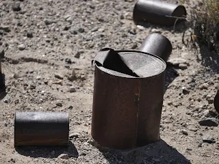
Using a knife to open - how old are these cans?

The day was wearing on and so was the heat. With open windows (no air since you don't want to over tax your vehicle in the heat) we traveled many miles but slowly. Everything moves slowly on the Mojave Road. One to view everything and secondly because that's how the road tells you to drive - real slow and careful.

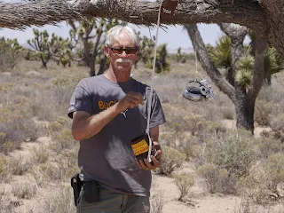
 By early afternoon, Lanfair Valley came into view and so did the 'penny can'. In the early 1980's someone decided to hang a can from a Joshua Tree and everyone who drove by was supposed to drop a penny into it - sort of a good luck thought we suppose.

Well - good luck always seems like the right thing to wish for.


The navigator needs luck


So does the driver


With all the luck a couple of pennies could afford, the dynamic duo hit the trail once again. Hour after hour of increasing heat and nerve wracking road brought the pair to Rock Springs. Of course, not until Dennis Casebier's statement (or understatement) came to fruition - "It is quite a steep hill" - describing the entrance to Watson Wash - no photographs were taken at this time since it was not steep in the normal sense but more like a ride from Disneyland.
The left side of the road did not match the right side of the road in height giving the FJ a thrill - if vehicles can get thrills. The driver wasn't thrilled standing on the brakes while the FJ continued on a downward motion toward the wash.

It's referred to as a 'white knuckler' by gripping the steering wheel so tightly as to cut off all blood flow to the fingers. J isn't a rock crawler and the FJ isn't designed as one but after grunting and huffing - J and not the FJ the wash was reached on a smooth drive to Rock Spring.


Camp Rock Spring looking east
Rock Spring was a famous stop for travelers through the desert - be that Native Americans or Pioneers. Water flowed from natural springs to the point that swimming holes were made for the pioneer children to cool off during the summer months. In 1866 an Army post was established called Camp Rock Springs to keep peace with the natives and the newcomers - especially the mail delivery. But around 1868 the Camp was closed since the mail and people didn't use the road much any longer with the introduction of the railroad miles away made the road not so needed.


Easy loop around historic site with information
Rock Spring can actually be driven to by any sort of vehicle as a large graded road takes the traveler to Bert Smith's rock house just above the springs.

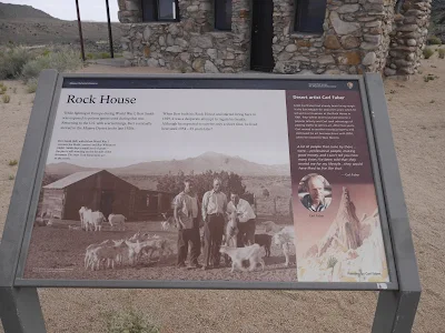
Bert Smith was a WWI veteran who suffered serious health issues by being exposed to poisonous gas while fighting in the trenches in France. Upon returning to the United States he was told that he had a short time to live. Well, Bert didn't believe that nonsense and moved to Rock Spring where he and his family built quite a nice abode above Watson Wash and lived until 1967. Way to go - Bert!


The beginnings of the Rock House by Bert Smith

Interior shot of the Rock House


 After visiting these sites it was time to move on but first there was one more stop before trying to find a place to bed down for the night.

We read about all the water in the desert and the greenery we had encountered during the day certainly proved it but where was the proof? We found it not far from Rock Spring - plenty and it was bubbling up from the earth with the assistance of a windmill water pump. There was and still is plenty of water to take care of the needs of the desert and those willing and strong enough to survive the harsh conditions. Cattle are still raised out in the area and water troughs can be found here and there - especially at the elevation of Rock Spring which is nearly 4700 above sea level.


Windmill water pump equals . . . 


Where's there wind there may be water and water plentiful near Rock Spring. And what does that mean for the desert? Hmmm... 
Water from the ground which equals  . . . 


Trees and life - like this majestic hawk
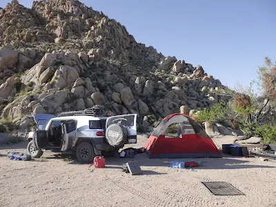
With dusk quickly coming, and after a day of exploration nearly done, it was time to find a place to camp for the evening. A nice place was found - soft sand, tall rock backgrounds to keep the wind at bay and actual fire pits. Again, this area can be reached by most high centered vehicles for a one night journey. Other than that a four wheel drive is a must - but that said, we made camp, talked about the days adventure, smoked a good cigar and enjoyed the desert night.

The Milky Way never looked as clear as it does when the nearest city lights are forty miles away or further. One of the benefits of traveling where most won't.


A perfect camp site


Let your imagination go and what do you see?


Thanks to Lori and Joe Villanyi for their photographs.

Please visit the Mojave Desert Heritage and Cultural Association for more information at -  www.mdhca.org


Saturday, June 11, 2016

Mojave Road Saga


Road less traveled - better have a GPS!
In Southern California there are two main arteries that flow through the Mojave Desert which are lifelines to the Colorado River and Las Vegas - Highways 15 and 40 are traveled more than most other black topped road surfaces in the United States. Millions of travelers per year drive these highways in search of gambling fortunes, cool river life, or just points beyond - what they both share is miles upon miles of desert landscape.


Towns such as Essex, Baker, Yermo, Barstow, Ludlow and numerous other exits (actually there aren't that many) are mere pinpoints on a map. The traveler drives and looks out the window at cactus, sage, blowing tumbleweeds and thousands of square miles of brown desert dirt.

This is the place Patton trained his tank crews for the operations in North Africa during WWII - it's desolate - it's lonely - it's rough and it's the right place for an adventure.

General Patton in the Mojave Desert during WWII
J along with his trusty companion Paul decided to drive or better yet maneuver the Mojave Road - that stretch of  nearly 140 miles dirt path that parallels the 15 and 40. It's the road which both native Americans traveled for hundreds of years as well as pioneers in the 1800's moving to the promised land. It's rough, dirty, a bit scary, and bloody hot - especially at the end of May and beginning of June where temperatures can easily reach over 100. It did - 102 and 103.

Laureen stayed poolside at home - the thought of night after night tenting in open hot rough country didn't appeal to her this time - dipping her feet into cool water did. This from the woman who loved the Amazon Rain Forest - well not really loved it but went along on that adventure wholeheartedly - the Mojave Road was a different matter. Besides who would look after the four doggies on the home-front?

The boys left on the morning of the 29th of May heading to the Avi Resort on the Colorado River - that would be the jumping off point.

Paul with the Colorado River in the background - the beginning.
Research had been conducted, maps printed, warnings of traveling in only one vehicle discussed and then put away, and the most important tool purchased. A Mojave Road guidebook by Dennis Casebier was a must since this individual has traveled the road more times than anyone could count and the directions - starting off at Avi - were right on with exact mileage and GPS coordinates.

A Must if you want to be safe!
As stated this was not a trip for the faint of heart - this would be like going back in time to follow the footpaths and wagon wheels of those who have gone on before us - the true pioneers who risked it all in an unforgiving desert for a better life. Unlike those John and Paul called once again on the intrepid Toyota FJ - the workhouse of so many of our blogs. The vehicle which has never let J and L down.

New tires, new steel rims, new off road bumper and a 9,000 pound winch were added to the FJ to ensure she (hope that's not taken as sexist) was ready for an off road ordeal. All research stated not to do the trip in one vehicle but one vehicle was all we had.

With the top rack loaded with an extra tire (the FJ already has a spare on the rear door) in case we encountered two blow outs, shovel, hard gravel rake, floor jack we were confident in the tire area. Plenty of water, extra gasoline, tent, cots, and all the other camping needs made us feel that we would at least have some comforts of home on this trip. The FJ was jammed packed with supplies but when the trip is supposed to take three days and may stretch into four one has to be prepared - cell phones are spotty at the best being this remote (in fact John was completely off the grid for nearly 36 hours and Paul's cell didn't do much better).

We followed Dennis's guidebook and learned that the desert isn't a place which is only brown but one of pure beauty and brimming with life. No, while driving on the 15 or 40 a person may look out at the brown of the desert and believe there is nothing worthwhile to view but they are totally wrong - there is so much to see and learn about the Mojave Desert - the only problem is its remoteness and sometimes unforgiving nature.

This road - this Mojave Road is only for four wheel drive vehicles and is only for those who want to get out of their comfort zone to learn the truth about what a beautiful and vibrant world there is between to long lines of black top.

In the next four or five blogs more details on this trip will be written about - hopefully the readers will learn to understand and love this piece of history - this road had to offer.

Not far from the Avi Resort 
We explored and gained knowledge about this part of Southern California we hadn't known existed.