No, we had not, and told him so.
“You should look into it. I think you’ll find it interesting.”
We did, and learned he was right. It was not only interesting, but the details described a horrifying moment in history that occurred about an hour and a half’s drive west from Victorville.
About noon on March 12th, 1928, the Bureau of Water Works and Supply Superintendent, William Mulholland, along with his assistant, Harvey van Norman, was checking on the St. Francis Dam, located approximately forty miles north-east of the city of Los Angeles. Mulholland had received a call from the dam keeper, Tony Harnichfeger, that there appeared to be seepage issues. Mulholland, along with van Norman, inspected the dam and concluded that the seepage was normal.
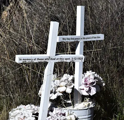
Twelve hours later, Harnichfeger, along with Leona Johnson, again inspected the dam. That was when the unthinkable happened. The entire northern side of the dam collapsed, spewing 12.5 billion gallons of water through the San Francisquito Canyon.
The initial waves from the collapse were nearly 120 feet high. Within minutes, the dam keeper’s house was destroyed and all his family were killed. Neither Harnichfeger nor his six-year-old son, Coder, have ever been found.
Within minutes, the waters struck Powerhouse #2, killing 64 workmen and their families living nearby.
The waters raced down the canyon at incredible speeds, reaching Castaic Junction with 55 foot waves. The small town was washed away.
Much more destruction and loss of life followed as the seemingly never-ending torrent of water struck the towns of Fillmore, Bardsale, and Santa Paula.
When the five-foot waves finally crashed into the Pacific Ocean, fifty miles south of Ventura, the loss of life was over 450 people. The exact number of humans lost will never be known. There were groups of iterant workers living in the canyon at the time as well as others looking for work camping out of doors in other areas where the waters tumbled.
Bodies of some victims were found days, weeks, and even months later, some as far away as the Mexican border. In fact, in 1992, the remains of a victim were found buried deep in the earth near Newhall. Many have never been found.
The St. Francis Dam disaster of 1928, is the second largest loss of life disaster in California history – only the 1906 San Francisco earthquake took more lives.
We researched the St. Francis dam disaster and knew a trip there was absolutely needed. So, we headed west on Highway 138, with our buddy Paul, past the towns of Littlerock, Pearblossom, and Palmdale.
The drive was beautiful. Once past Palmdale, the scenery turned idyllic with green rolling hills and large trees hugging the roadway. It was ironic to witness all the life swishing past the windows on the way to a canyon of such deep sadness.
We weren't sure what we would find at the site of the former dam. In 1929, the remaining sections of the dam which had remained standing were dynamited, bulldozed, and jackhammered to pieces. This was done to keep the curiosity seekers from spilling over the area for macabre souvenirs.
 |
| Large pieces of concrete from the dam litter the valley |
 |
| Using a drone for aerial shots of the disaster scene |
 |
| Beautiful walk toward a past human disaster |
 |
| The area is just beautiful and sad at the same time |
 |
| Just one large piece of concrete torn loose from the dam during the disaster |
 |
| A touching memorial for the victims of the dam disaster |
“What was the reason for the dam collapsing?” I asked.
“Lots of ideas were floated around, but I think the main one was that after the dam broke, and the investigation began, it was discovered that there had been an ancient landslide where a portion of the dam was built. They didn’t have the technology back then to know that,” he said.
 |
| John talking with Chris Hertzberg |
“Different engineers must to be involved in these things to ensure everything is correct. Research must be thorough and complete,” Hertzberg stated. “Can’t leave it up to one, self-taught engineer like Mulholland.”
In an effort to prevent such a disaster from happening again, in 1929, the California legislature enacted a new law, that any non-federal dams had to be inspected by the state. Prior to that, any municipality could build a dam with no input from the state.
The site is beautiful, sad and peaceful. The lives lost deserve to be remembered. Consider stopping by this historical site.
For directions:
https://scvhistory.com/scvhistory/st-francis-directions.htm

No comments:
Post a Comment