Pages

Showing posts with label Toyota FJ. Show all posts

Monday, July 11, 2016

Mojave Road Saga - Day 3

One rule J and L stick to, most times, is never to have a cold adult beverage until the day is done. Sitting around discussing the day’s adventure is time to celebrate.

It was no different on the third day upon the Mojave Road, so when Paul and John started seeing gnomes, frogs, toy jeeps, and a plethora of eclectic plastic entities, a question arose: did the boys break with the almost constant golden rule?

They had NOT but the images below will surely make the reader understand why they questioned themselves.

Gnomes going on a trip to the Mojave Road

There's even solar powered 'Ribbet' sounds from some


Even bobble-headed sports figures

The White Rabbit - it explains it all


It seems the game of placing such items near a heavy steel Mojave Road Mailbox at mile 74 has become a fad – a rather large one. It began in 1983 being erected by the Friends of the Mojave Road so visitors could sign a guest book telling others about their trip.


Paul guarding the Mojave Road Mailbox


Proof the boys were there
Fascinating - albeit a bit creepy!

On the road again, as the duo took to the Cimacito summit at 4556 feet above sea level where the view of the desert valley was awesome. Mile upon mile of empty vastness reminded the travelers again of the excitement and danger such a remote road the Mojave is.

Three days and no other vehicle had been seen. Weird and spooky.

Coming across Willow Wash the guide book warned of soft sand at Mile 81.8 and it was more than correct. A steady hand on the wheel, steady touch of foot to pedal, and steadier eyes were needed to navigate the long stretch of sand.

Having driven through deep sand before was no problem, but the length of the wash rather took the fun out of the nearly 6 1/2 miles we had to maneuver. Of course, this was child’s play considering what we came across on a few hours later which was nothing but a white-knuckler. 

The day sped on and so did the miles. Around one in the afternoon the boys decided it was time for lunch. Taking out the ‘easy-up’ and erecting it on Soda Lake at a temperature a little over one hundred degrees seemed the best spot.

Perfect place to relax in triple digits
No wind and the sun baking down on top of the nylon man-made shade made for a wonderful lunch location. Hard boiled eggs, tuna on crackers, water, and a western view of the ancient dry lake bed was all that was needed.

Though – it was hot and getting hotter. Off to Afton Canyon to find a spot to camp.

The Travelers Monument - a collection of rocks in a heap with an American flag was the place was the place to stop. Photos were taken and then back on the road. Not really much to see actually and it was getting hotter by the hour.

Very Patriotic and well worth the stop.
After leaving the monument is when things got a little nerve whacking. 

Railroad bridge just east of the entry to Afton Canyon
Easy sand compared to earlier in the day
At mile 106.8, Casebier states in his book that there is a steep hill at Shaw Pass which then leads into a wash. This may have well said quicksand. 

The sand for the next 10 miles was brutal. Unbelievably soft from the daily barrage of desert winds bringing soft particles to lay upon one another. The wash was not a road - not in anyone's mind. 

No photos were taken since Paul was navigating by searching for the cairns to ensure the FJ stayed it's true course and John was gripping the wheel with all his might. 

The travel was fast but progress was slow. Each bend in the wash brought new challenges - deeper sand and wondering when the next cairn would turn up. 

At one point the boys lost sight of all markers and nearly made a fatal error (remember one vehicle, triple digit temperatures and sketchy cell phone service). Going north along the deep sand John was about to continue in the direction until Paul yelled "left - go left" and there on the edge of an island of river rushes was a cairn. The FJ careened on it's wheels, the steering wheel was yanked left and the tires shuddered to a near stop. But the 200 plus horsepower kept the momentum going. It was actually pretty close to being sunk.
Imaginations can soar like the cliffs here


What happens if a car gets stuck in the sand? With no back-up available a decision has to be made. Walk out of the desert to the nearest settlement over twenty miles away or wait it out - luckily the FJ performed as it always does. It didn't get stuck and we continued to the mouth of Afton Canyon.


Are those parapets with Knights with bows behind them?

A peaceful and gorgeous canyon of high cliffs and wondrous colors.
It had been exhilarating, exhausting, and educational.


The first night in awhile to sleep in a fixed campground. It was a sight for tired eyes - but again - no one else around.


View from Afton Canyon campsite
Now it was time for a cold adult beverage, a cigar and hopefully a good night’s sleep.

The cold drink and cigar proved possible but tons of mosquitoes and a very hot night inside a tent did not allow a good night’s sleep.

Oh well – that’s how many adventures go and to the explorer just another day on the job.

Saturday, June 11, 2016

Mojave Road Saga


Road less traveled - better have a GPS!
In Southern California there are two main arteries that flow through the Mojave Desert which are lifelines to the Colorado River and Las Vegas - Highways 15 and 40 are traveled more than most other black topped road surfaces in the United States. Millions of travelers per year drive these highways in search of gambling fortunes, cool river life, or just points beyond - what they both share is miles upon miles of desert landscape.


Towns such as Essex, Baker, Yermo, Barstow, Ludlow and numerous other exits (actually there aren't that many) are mere pinpoints on a map. The traveler drives and looks out the window at cactus, sage, blowing tumbleweeds and thousands of square miles of brown desert dirt.

This is the place Patton trained his tank crews for the operations in North Africa during WWII - it's desolate - it's lonely - it's rough and it's the right place for an adventure.

General Patton in the Mojave Desert during WWII
J along with his trusty companion Paul decided to drive or better yet maneuver the Mojave Road - that stretch of  nearly 140 miles dirt path that parallels the 15 and 40. It's the road which both native Americans traveled for hundreds of years as well as pioneers in the 1800's moving to the promised land. It's rough, dirty, a bit scary, and bloody hot - especially at the end of May and beginning of June where temperatures can easily reach over 100. It did - 102 and 103.

Laureen stayed poolside at home - the thought of night after night tenting in open hot rough country didn't appeal to her this time - dipping her feet into cool water did. This from the woman who loved the Amazon Rain Forest - well not really loved it but went along on that adventure wholeheartedly - the Mojave Road was a different matter. Besides who would look after the four doggies on the home-front?

The boys left on the morning of the 29th of May heading to the Avi Resort on the Colorado River - that would be the jumping off point.

Paul with the Colorado River in the background - the beginning.
Research had been conducted, maps printed, warnings of traveling in only one vehicle discussed and then put away, and the most important tool purchased. A Mojave Road guidebook by Dennis Casebier was a must since this individual has traveled the road more times than anyone could count and the directions - starting off at Avi - were right on with exact mileage and GPS coordinates.

A Must if you want to be safe!
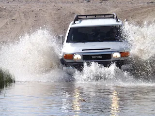
As stated this was not a trip for the faint of heart - this would be like going back in time to follow the footpaths and wagon wheels of those who have gone on before us - the true pioneers who risked it all in an unforgiving desert for a better life. Unlike those John and Paul called once again on the intrepid Toyota FJ - the workhouse of so many of our blogs. The vehicle which has never let J and L down.

New tires, new steel rims, new off road bumper and a 9,000 pound winch were added to the FJ to ensure she (hope that's not taken as sexist) was ready for an off road ordeal. All research stated not to do the trip in one vehicle but one vehicle was all we had.

With the top rack loaded with an extra tire (the FJ already has a spare on the rear door) in case we encountered two blow outs, shovel, hard gravel rake, floor jack we were confident in the tire area. Plenty of water, extra gasoline, tent, cots, and all the other camping needs made us feel that we would at least have some comforts of home on this trip. The FJ was jammed packed with supplies but when the trip is supposed to take three days and may stretch into four one has to be prepared - cell phones are spotty at the best being this remote (in fact John was completely off the grid for nearly 36 hours and Paul's cell didn't do much better).

We followed Dennis's guidebook and learned that the desert isn't a place which is only brown but one of pure beauty and brimming with life. No, while driving on the 15 or 40 a person may look out at the brown of the desert and believe there is nothing worthwhile to view but they are totally wrong - there is so much to see and learn about the Mojave Desert - the only problem is its remoteness and sometimes unforgiving nature.

This road - this Mojave Road is only for four wheel drive vehicles and is only for those who want to get out of their comfort zone to learn the truth about what a beautiful and vibrant world there is between to long lines of black top.

In the next four or five blogs more details on this trip will be written about - hopefully the readers will learn to understand and love this piece of history - this road had to offer.

Not far from the Avi Resort 
We explored and gained knowledge about this part of Southern California we hadn't known existed.


Wednesday, November 20, 2013

Conspiracy Theory

It seems the month of November, especially this year, is the time of conspiracy reminders. With the 50th anniversary of President John F. Kennedy's assassination, the 150th anniversary of the Gettysburg Address (not to mention all the rumors surrounding President Lincoln's assassination), and the recent film regarding the Space Shuttle Challenger disaster and the 'stonewalling' surrounding the investigation into the cause of the accident, J and L decided to add to the phenomena of conspiracy theories. Not that we have anything even close to these monumental mysteries, but what the heck, these are the things which make America such a great, and interesting country.


During the course of research for an upcoming novel, Operation Scorpion, J decided to take a drive out to the Yucca Mountain Nuclear Depository. You know, the one located in southern Nevada which has supposedly had over ten billion American tax dollars spent constructing the facility, only to have it defunded and 'abandoned' in 2010.The remote location in the Amargosa Desert is home to the Nellis Air Force Range, and, coincidentally, also the location of the ever-fascinating Area 51. Yes, the same Area 51 around which stories swirl regarding little green men being dissected after crash-landing in Roswell, New Mexico in 1947.

Can it get any better than this?

J had written to the Nuclear Waste Department in Eureka County, Nevada, requesting a tour of the facility which had been under planning and construction for decades. It is a fascinating engineering project, designed to provide a space for the safe disposal of all nuclear wastes produced in the United States for thousands of years (please refer to the sites listed at the end of this blog for confirmation and further detail).

Our traveling companion during this adventure was the frequent fellow-explorer, Paul Bakas, good friend and photographer.

There had been no response from the Waste Department, so the adventure was afoot as we try to find our own way in, as did some of the characters in Operation Scorpion (due for release in 2015).

A quick three and a half hour drive north to Baker, then northwest to the town of Amargosa Valley at the junction of Highways 373 and 95, and we thought we'd be near the entrance, if not the footprint of the nuclear site.

We were wrong.

We stopped and asked for directions at three different establishments, including the Chamber of Commerce, but no one could give us directions to the facility. Rather strange, we thought, considering the scope of such a repository for nuclear waste, including a purported five mile long tunnel built into the Yucca Mountains before being defunded.

Hard to hide such a thing. Or was it?

Off to the hinterlands, four-wheeling in the trusty Toyota FJ for hours upon hours of searching, but to no avail.There were plenty of hard-packed dirt roads, large enough for construction vehicles, and a few signs for YMP (Yucca Mountain Project) personnel, but no discernible entrance to the increasingly mysterious facility.

Dusk was smothering the mountains as we decided to call it a day. We were dirty, tired, frustrated, and hungry. So we drove back to Beatty where we had decided to set up camp for the evening.

This is when it really got strange.

Sitting down to a nice dinner at the Sourdough Saloon with a cold beer, J's cell phone pinged and up popped an email from the Nuclear Waste Advisor (who shall remain anonymous) stating that there were no tours of the area because the program was shut down. The site had not been licensed to receive nuclear waste and all there was to see was an exploratory tunnel, but nowhere to store material.

Really?


I shared the email with my fellow explorer, Paul, and his eyebrows curled a bit upwards. "Rather odd to receive such an email right after we spent the entire day driving around the back end of the thing, wouldn't you say? Almost as though someone knew we had been there snooping around."

"Since I sent the first email weeks ago asking for a tour and explaining my reasons. Yes, I would agree with you."

Paul nodded. Not really much of one to dwell on conspiracies, his reply was to change the subject.  "And I agree this food is tasty and the beer cold."

Couldn't argue with that logic, but there was certainly a growing sense of confusion and yes, perhaps a little paranoia floating around in my cranium.

That confusion turned to something more quizzical as we left Beatty the following morning and headed into the very small town of Death Valley Junction for breakfast. We discussed our empty-handed mission of the previous day with a friendly waitress, who shall also remain nameless -- the reader will understand why. I mentioned our search and the contents of the email I received from the waste department.

"That's funny," the waitress observed. "My husband worked there and we have drivers coming through who say they already are delivering low level radioactive material out there. They have armed guards surrounding the entry gates to Mercury. Strange message to write saying it's not open when we all know it is."

And this is how governmental conspiracies begin!


Tuesday, October 8, 2013

The Road Less Traveled


Why taking the road less traveled is worth it

Visibility Measured in Feet
 On September 21st J and L decided to head north out of the small town of Trona after visiting the Trona Pinnacles and drive to Panamint Springs on the way to Highway 395. Little did we know that the Trona-Wildrose Road was closed about fifteen miles north of the town due to massive flooding on July 22nd and July 28th respectively. Coming upon a road closure sign post with large dirt berms blockading the roadway showed the county of Inyo meant business on keeping the 150 to 200 vehicles which used the road each day.


Being researchers and explorers we simply slipped the Toyota FJ into four-wheel drive and pulled into the sandy desert bypassing the blockades. We were on a mission to get to Panamint Springs through the Panamint Valley and weren’t about to backtrack to Trona just because of some supposed washed out highway. The team does caution others to perhaps not follow our lead but with years of experience in the desert we try to be prepared for any conditions which we may encounter. Those preparations have paid off time and again as we leave the comfort of the pavement and head into the hinterlands.

 What J and L quickly saw ahead of them was a Hollywood version of a highway caught right after an end of the world film.

Where's the shoulder?
Hunks of asphalt missing, road cave-ins on either side of the roadway, buckled surfaces threatening the very existence of our powerful war horse, and the strangest sensation was there were no other vehicles to be seen. For nearly twenty miles we drove through this land of devastation without seeing another human or any sign of life for that matter. To even deepen the feeling of traveling through an apocalyptic period was the miles wide and thousand foot high sand storm directly to our east. The twirling and blowing dark sand seemed to follow us menacingly as we drove carefully and very slowly northward. But, again, being who we are we finally turned the FJ into the very desert that gave existence to the sandstorm so we could get better photographs.

The wind and fine sand were pounding us as we exited the vehicle and started snapping and filming.
It was awesome.

View from the Top

After a few minutes of being sandblasted it was time to retake our position inside the vehicle and finish the journey we had started an hour earlier. With visibility nearly zero at times we finally drove around the north barriers and entered onto State Route 190 and turned west toward Panamint Springs. 

A cold beer for J and a Coke for L at the Panamint Springs Resort was the perfect ending for an adventurous and exciting, though sometimes worrisome, travel through Panamint Valley. 


Tourists  at the resort were busy snapping photographs of the tall blowing sandstorms to the east and making comments like: “They look so dangerous.” “Look how they tower above the landscape for miles and miles.” “You would not catch me out there in the midst of it.”


Haboob - Arabic for blasting/drafting - first named in the Sudan

Oh, what they had missed by not traveling the road less traveled.

Looking east from Panamint Springs toward Death Valley

On a side note – according to the Inyo Register the cost to prepare the Trona-Wildrose road will be in the millions and the time to prepare it is undetermined due to the severity of the thunderstorms which wreaked havoc through-out many of the roads in Death Valley and surroundings desert locales. 

As always, stay careful and be prepared for the unexpected.


Tuesday, May 21, 2013

Ode to a Work Horse

Original Toyota Land Cruiser

Toyota has always built a strong and reliable vehicle but until J and L purchased the newly updated version of the old Land Cruiser did this writer know how tough and reliable they truly were. We were the first to take delivery of the 2007 Toyota FJ back in 2006 in the city of Victorville and loved the Cruiser the moment the ignition key lit the beast up and we drove out of the dealership.

'New' Retro Toyota FJ
The auto maker knew a good thing when they came up with the retro Land Cruiser from the sixties and seventies introducing one of the best off road vehicles in the world according to most industry reports. We did not realize how accurate those publications were until we took a short one thousand mile road trip within the first six months of owning the vehicle down south through Baja California to Cabo San Lucas along some of the worst roads Mexico has to offer.

Just before dusk on a lovely Tuesday evening J and L were racing down a rutted gravel path falsely listed as a road on a torn map listening to Phil Collins on the CD player belting out 'Something in the Air Tonight'. At that moment I did not realize Mr. Collins was alluding to us.

Laureen calmly looked over at me from the co-pilot seat and smiled sweetly. "Honey, there's no road in front of us."

I unconsciously shut my ears to Phil and widened my eyes to witness the front of the FJ grab air and suddenly we were the 'something in the air' that the crooner had been mentioning.

A line from Zachary Marshall, the antagonist from my novel Hunted, came into mind as he plunged a stolen Cadillac Escalade off a roadway and nose dived it onto a busy highway below. "This is going to hurt."

When the FJ finally landed, luckily on all four wheels sixty feet north and eight feet down into a dried river bed it didn't hurt. It didn't hurt at all.

The FJ was amazing.

click the link below for the Ode to A Work Horse Slide Show


After that trip through the wide open deserts of Lower California the Toyota has been on countless road trips exploring and researching all over the United States and never failed once.  Heavy snow drifts, torrential rain on muddy roads or nearby tornadoes weren't enough to even slow the six cylinders down but in fact seemed to the give the FJ more power and strength.

In fact, in all the time we've owned the Cruiser not once have we ever had to put snow chains on while visiting our weekend home in Big Bear but simply slipped the transmission into four wheel drive and off we went. The wheels gripping firmly and securely while all the rest of the travelers had chains or cables wrapped snugly about their tires.

Though it has dents, scratches and overall looks like it's been through hell, much like the main driver, it is still a beautiful machine.

One well worth a mention now and then for all its given us on the many adventures from the past and we pray well into the future.