With each new year, there is a chance to reflect and make each one of us a much better person - the world needs that, and together it can become a reality.
Happy New Year!

Helen Keller
With each new year, there is a chance to reflect and make each one of us a much better person - the world needs that, and together it can become a reality.
Happy New Year!
Helen Keller
As we travel through this Holiday Season, we want to wish all our friends and loved ones a very Warm and Merry Christmas - and to always remember the reason for the season is -

Laureen, my wonderful wife, promised we would be seeing Puffins in Nova Scotia. She wanted to see Puffins in Nova Scotia. She was excited to see Puffins in Nova Scotia.
I always thought a Puffin was something Pillsbury made for breakfast.
Actually, a Puffin is any of three species of small alcids (auks) in the bird genus Fratercula. These are pelagic seabirds that feed primarily by diving in the water. They breed in large colonies on coastal cliffs or offshore islands, nesting in crevices among rocks or burrows in the soil.
 |
| A Puffin just enjoying life |
Not being an Ornithologist, I have no idea what all that means except a Puffin is a sea bird and Laureen was keen on seeing them.
Being the doting husband I am, it would be Puffin-hunting season when we arrived in Nova Scotia - figuratively speaking only. How could anyone want to harm these little clowns of the sea? With their black and white bodies, orange feet, and a multicolored beak sporting stripes of orange, yellow, white, and black, they definitely appear ready to jump out of a Volkswagen with 300 of their closest aquatic friends.
We crossed the eight-mile-long Confederation Bridge from New Brunswick to Prince Edward Island and I suggested Laureen take a gander far below at the beautiful but somewhat foggy surface of the Northumberland Strait.
“Nope,” was her reply. She doesn’t like bridges of any height or length - the Confederation Bridge is very long and very high above the ocean.
It was so cool. “Do you feel it vibrating?”
Spotting a gift shop as soon as we crossed over into the town of Borden-Carleton, I realized I would soon be paying for my smarmy remark about the shaking bridge.
We stopped at the Gateway Village and soon were patrolling huge shops filled floor to ceiling with every sort of tourist trinket, tourist apparel, tourist photographs, and so many other tourist items that I truly believed locals were not allowed into the village.
Approaching a clerk while Laureen was loading up a couple of shopping carts, I asked the woman where we could see some Puffins.
“That would be New-Found-Land,” she replied. “There be no Puffins on Prince Edward Island.”
It was at that time I came to the rationalization that we would not be seeing Puffins and I had pronounced Newfoundland wrong for my entire life.
I was taught by a teacher in elementary school that New-fun-lund was somewhere in Canada.
So much for the private school my parents had paid for while growing up in Riverside, California.
With the boot, which is a trunk in Canada, full of loot I broke the news to Laureen.
She merely shook her head and said, “I have faith we will see a lot of cute Puffins.”
A week later we saw the elusive Puffins and they were not in Newfoundland, but in Cape Breton Island near the very small town of Englishtown along St Anns Bay - which happens to be part of Nova Scotia,
Driving along the 105 toward Baddeck I saw a road sign advertising Puffins tours. I hit the brakes, threw out the anchor, and careened onto the 312.
“What are you doing?” Laureen asked while hanging onto the handgrip near the passenger seat of the rental.
“Keeping your faith alive.”
Within a few kilometers, which is really cool since they are shorter than miles, we pulled up to Donelda’s Puffin Boat Tours.
 |
| All of us lining up for the Puffin Tour |
Turns out that the owner of the boat tour, Donelda has run the business for over 28 years with her husband John - sadly we were informed that John had passed away recently, but Donelda was keeping the tours as well as their lobster business alive in his honor.
Donelda is known as the ‘Puffin Lady’ around St. Ann’s Bay.
We signed up for a three-hour tour, which gave me a bit of an apprehensive feeling, thanks to growing up with the television show, Gilligan’s Island.
I shrugged it off but it suddenly came back as we were about to board the sightseeing boat, Highland Lass, when I heard a man ask, “Lovey, did you remember to bring stacks of money?”
The tour would include visiting an official bird sanctuary located off Cape Dauphin which consists of actually two islands - Hertford and Ciboux.
I asked the owner just prior to casting off if people could land on either of the islands.
Donelda replied, “I’ve been doing these tours for a long time and let me tell you, I or any other tour operator would not stand by idly if we saw trespassers on these islanders. By law, no human can set foot on either island so the natural habitats of these sea birds will remain pristine.”
Though she was a very warm and funny person, I was sure that if she caught someone trespassing on either of the Bird Islands, she would tow them back to the harbor in a lobster trap.
 |
| One of the Bird Islands the tour investigates |
As we powered out into the bay for the tour, Donelda went through a few minutes of boat safety in case the boat was struck by a mine, iceberg, or torpedo. Then for the next forty minutes, the woman explained the various types of marine life we would be observing.
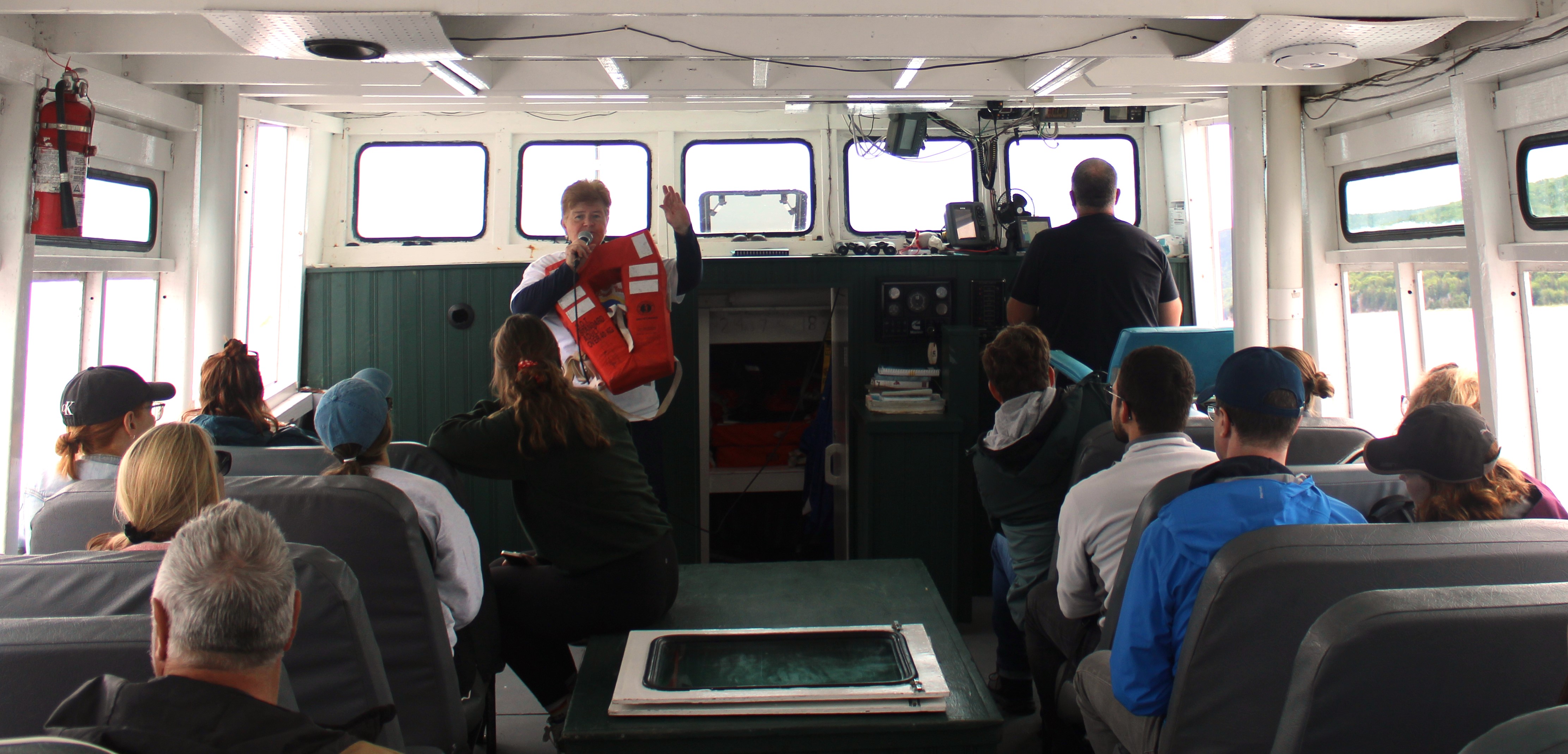 |
| Donelda going through the safety drill with passengers. |
“We will be seeing a lot of different sea birds during this tour,” Donelda said while holding up large colored photographs.
“There will be Artic Terms, Common Loons . . .”
“Don’t,” Laureen whispered to me.
“. . . Common Elders . . .”
“Don’t,” again the whisper.
“. . . Red-breasted Mergansers, Belted Kingfishers, Great Blue Heron, and of course many Bald Eagles.”
Almost on cue, the Captain, who did not resemble Alan Hale Jr., stated that to the port, that is the left side of the boat facing the bow, was a Bald Eagle. Instantly, Donelda climbed out to the exterior and grabbed a large Mackerel out of a bucket.
“Watch the fish,” she yelled while tossing the fish into the waters beside us. Within moments that huge majestic Bald Eagle swept by within yards of the 41-foot Highland Lass and snatched the fish up with its huge talons.
It was marvelous to see this bird, so cleanly drop from the sky and quickly pick up the fish floating on top of the water.
During that tour, if we did not see three dozen Bald Eagles I would be surprised.
 |
| Eagle catching a fish right next to our boat |
Soon we plowed through the semi-rough waters and reached the bird sanctuaries - and Laureen got her wish. Besides all the birds Donelda had mentioned were on full view darting here and there, there were hundreds of the tiny little Puffins.
Some were floating in the water, where they actually spend most of their lives, and others sitting atop the craggy cliffs of the islands, safely tucked away in the nooks and crannies carved into the rock faces created by wind and waves.
I was somewhat shocked at how small the Puffins were. Photographs I had seen in the past gave me the impression they were just a bit smaller than Arctic Penguins. Nope, they were tiny - but they did waddle a bit like penguins. Reminded me of Charlie Chaplin, if he was a Puffin walking around on the Bird Islands.
The Captain slowed the boat and for the next hour or so, we cruised within yards of the islands snapping photos with phones and cameras marveling at how many different varieties of birds lived together in this sometimes harsh environment.
“They are so cute,” Laureen said with a large smile while pointing at the Puffins. It made me happy to see her light up while looking across the waters toward these little Clowns of the Sea.
After taking so many photographs, we just went outside to the aft and took in all of what nature had to offer that afternoon.
 |
| And nature had a lot to offer. |
Cool blue waters with brilliantly white wisps of waves curling here and there on the surface, dozens of sea birds flying overhead in the clear sunlight, families of Harbor Seals frolicking along the shorelines or just out sunning themselves, and feeling the ocean breezes against our faces made for a perfect day of adventure.

 |
| Show Off! |
As the Highland Lass headed back to its berth near Englishtown, Donelda told us that the area near the small fishing port dates back to 1597 by the French, later becoming part of the English Empire.
It is one of the oldest towns in North America.
Mission accomplished - the search for the Puffins was complete and I knew once we bumped into the wooded docks, there may be a new search for a pub near Englishtown, which seemed apropos.
For more information: https://Puffinsboattours.com/our-tours/
John can be reached at: beyersbyways@gmail.com
 |
| The wharf at Baddeck, Novia Scotia |
Traveling often means discovering things that are sometimes unexpected. I’m not talking about such things as teenagers not functioning as humans before noon, or when your wife mentions that a restroom would be welcomed ‘soon’ which translates to means 'right now’ when the nearest town is an hour away.
No, those things are just facts.
It is those moments when traveling when one person turns to the other and utters, “Wow, check that out.”
Laureen, my lovely wife, and I had one such experience as we entered the town of Baddeck in Nova Scotia.
Baddeck is a quaint town sitting along the shores of Bras d’Or Lake. Despite its French spelling, the name is said to have originated from the native Mi'kmaq meaning ‘the long saltwater’, which stretches all the way to the Atlantic Ocean.
Baddeck looks like a Hallmark setting. A beautiful wharf with fishing boats, trees, and green grass stretching to the shoreline, fancy restaurants, vintage hotels, and a princess gazing into the distance for her prince.
 |
| The original post office in Baddeck, Nova Scotia |
Laureen told me that it was not a princess but a woman who dropped her phone into the water and was yelling at her husband to get it. But, I will stand by my story - her blonde hair was flowing majestically in the slight breeze as she scanned the horizon for her White Knight.
I’m a romantic, all truth be told.
The town of Baddeck was founded in 1908, but the history goes way back to the 17th century when French missionaries started a settlement in nearby St. Anns in 1629, twelve miles to the north.
It is rumored the French declared, “Les Anglais ne connaîtront jamais cet endroit.”
Well, the English did find the area during the 18th century when the French were forced to give the whole territory to the British Empire.
It is also rumored that the French may have said, “Au diable les Anglaises.”
So, as Laureen and I entered the town to locate our hotel, we passed a large sign that suggested we may enjoy visiting a certain museum.
And this is where that unexpected thing when traveling happens: it was the Alexander Graham Bell National Historic Site.
 |
| Alexander Graham Bell National Historic Site, Baddeck, Nova Scotia |
And as any good American, even though technically we were still in America, you know what I mean. I was flabbergasted.
“They need tourism in Cape Breton so badly that they stole our inventor of the telephone?” I asked Laureen.
What next? This is where Sasquatch is seen more frequently than in the state of Washington, or Area 51? And he is really guarded by the Royal Canadian Mounted Police?
Turns out that Alec, as he liked to go by, had traveled to the Baddeck area years in the past and had fallen in love with the town.
The young Bell had started his life in Scotland but due to health problems, including the death of his two brothers to tuberculosis, his mother and father decided to move to the United States for a better climate.
It worked, and the young man soon became an inventing genius.
At 18 years of age as he was working for a man who sold corn, Alec developed a method of instead of having manual labor shuck the stalks, a machine could do it.
It worked and Alec is credited with the saying, “Ah, shucks.”
As the years wore on Alec became more and more a man of invention. His father worked with various methods of assisting those without hearing actually to communicate and Alec made that part of his life goal. He became a speech teacher helping those, including Helen Keller.
In fact, his wife was a former student of his who was barely capable of hearing - but due to the extraordinary work from both his father and himself, Mabel was able to speak and read lips to the point that most did not realize she had any hearing issues.
It should be pointed out that Bell’s own mother was deaf but learned how to speak through the research and study by her husband who handed this down to his son.
Bell established the American Association to Promote Teaching of Speech to the Deaf in 1890 and is still doing wondrous things to this day for the hearing impaired.
So, we wandered into the Alexander Graham Bell Museum and were blown away by what we learned.
In 1876, when Bell famously yelled into the telephone mouthpiece, “Watson, get me a ham sandwich.” Life changed for the entire planet.
And that set Bell into the history books, which also made him a fabulously wealthy man.
A point learned at the museum was that Bell did not care that much about money. He enjoyed the benefits for humanity but when one of his inventions, and he had countless, went public he dropped interest and moved on to the next idea.
 |
| A replica of Bell's study at the museum, Baddeck, Nova Scotia |
Missing Scotland, Bell convinced his wife that they needed to find a place that would bring that sense of home back to him.
They traveled here and there, with his newfound funds, and happened to stop by Baddeck on one of their adventures.
With the lure of the green hills, tall trees, huge estuary, and rivers, this was the place for him.
Mabel and Alec settled on a point called Megwatapatek, named by the Mi’kmaq meaning ' Red Head’ due to the reddish sandstone rocks at the end of the peninsula.
The Bells purchased 600 acres and built a beautiful home there and other residences for family members. The property is still owned by the descendants and no non-family members are allowed unless they are guests.
 |
| Bell's estate near Baddeck, Nova Scotia |
I tried, even showing my press pass.
I did not know how cold the waters of the Bras d’Or Lake were in late June until the security personnel tossed me into them.
The museum was enlightening into the life of Alexander Graham Bell.Most think of him only as the inventor of the telephone, but he was so much more.
He had a total of 18 separate patents and 12 he shared with other brainiacs which included devices to assist the deaf, phonographs, multiple telegraphs at one time, photographs, metal detectors, and so much more.
We spent hours within the large museum marveling at this and that. All the inventions Bell was involved in were amazing. His wife once said that got his greatest creative ideas by floating in the waters by their house in Baddeck while smoking a pipe, an event that could fill an entire day.
He always carried a small notebook and scribbled notes in it constantly.
I suggested Laureen take that stance when I was floating in our pool at home with a cold adult beverage but her eyes rolling stopped that idea.
Bell even got into human flight.
He loved kites and often over the peninsula where their home was, the folks in Baddeck may have seen a dozen various colored and shaped kites skirting the breezes above their land.
The fight for dominance of who could put a human into the air was intense - some guys by the name of the Wright Brothers were doing it but everything was in secret, but Bell believed in publicity.
So, on February 23, 1909, Bell along with a host of like-minded fellas, launched the Silver Dart into the air off the shores of the Baddeck estate, creating the first powered heavier-than-air craft in Canada with a human.
A few years later, Bell and those engineers around him came up with the first hydrofoil concept of a plane that could take off and land on water.
 |
| Bell's original design of a hydrofoil, Baddeck, Nova Scotia |
On September 9, 1919, the vehicle took off from the waters of Bells Home and reached a speed of nearly 71 miles per hour.
Though through the years the concept would become indispensable for the military, when the First World War was done, there was not much interest in Bell’s idea.
It was decades later that the military realized Bell was far ahead of almost everyone and now hydrofoils are utilized by all branches of the service.
In a fitting farewell for one of the United States' most prolific inventors, during his funeral after his death on August 2, 1922, every phone in North America was silenced in tribute to the inventor.
Even in death, Alexander Graham Bell was to be noticed.
For further information: Alexander Graham Bell National Historic Site (canada.ca)
John can be reached at: beyersbyways@gmail.com

Often, between Halloween - a Holiday we love, and Christmas - a Holyday we love, we often forget the importance of the Holiday of Thanksgiving.
It is not only a day to spend with family and friends over a lavish feast spinning tales or watching sports but one of simply being thankful for those we love.
That is the utmost importance. To be 'Thankful' for those we love, present and past.
So, this upcoming Thanksgiving, please remember the words of Marcie, from A Charlie Brown Thanksgiving.
'We should just be thankful for being together. I think that's what they mean by Thanksgiving, Charlie Brown.'
To be just -

 |
| Memorial for the Swissair Flight 111 near Peggy's Cove, Nova Scotia |
Often when traveling, the adventurer will come across a locale they were not expecting, which makes journeying here and there so much more enlightening.
But that journeying can also conjure up feelings of sadness when tragedy is suddenly remembered as though it were yesterday.
For those of us old enough, it is like knowing where you were when President John F. Kennedy was assassinated, or where you were when the first hint that 9/11 was more than just one airplane crashing into the North Trade Tower at the World Trade Center.
There are just those moments in life, no matter how many days pass, a specific memory is seared into the subconscious for all time.
And that is what Laureen, my lovely wife, and I found while driving southwest toward Peggy’s Cove, less than an hour's drive from Halifax in Nova Scotia.
It was one of those perfect mornings where the sun was shining, birds were singing, the ocean water could not be bluer and a Sasquatch was playing an acoustic guitar while a moose was singing wonderful melodies of life in the forest.
Driving along the coastline passing tiny towns with names such as Glen Haven, Seabright, Glen Margaret, and others seemed to be flipping through wall calendar pages in real time.
Fishing villages dotted the blue Atlantic waters with lobster traps lining the shores. Colorful homes, small and large either hugging the rocky beaches or laid back amongst long stretches of green grass with pristine forests as their backgrounds.
I used the phrase, “This is such beautiful scenery,” so often that it even began sounding redundant.
We stopped and snapped a few photos at French Village, a quaint way station for boats moving in and out of the large bay on their way to or from fishing. A large boatyard piqued our interest and time was spent walking along the docks and gazing at the massive boats laid up onto wooden inland docks awaiting their turn for repairs.
The entire drive was idyllic.
Closing in on Peggy’s Cove, which we had chosen as the destination for this day’s outing to view the iconic lighthouse and have a light lunch, we drove by a sign stating that a memorial for Swissair Flight 111 was at the next turnout.
And that is when those certain memories which may hide in the wrinkles of the brain, leap out.
“I didn’t know,” Laureen said.
My reply was to brake slowly and enter the parking lot reserved for visitors who want to stop and walk a short trail to wonderful artwork that recalled a horrific accident that claimed 229 fellow humans only a short five miles out in the cold Atlantic Ocean.
 |
| Laureen Beyer looking out towards where Swissair Flight 111 crashed into the ocean |
On a warm evening on the 2nd of September of 1998, Swissair Flight 111 was scheduled for a routine flight from JFK International Airport in New York City to its destination of Cointrin Airport in Geneva, Switzerland. The plane taxied the runway and took to the skies at approximately 8:17 PM.
The 215 passengers may have believed they were heading off for a fantastic and well-deserved vacation or perhaps to nail a business deal that had been in the works for months. The crew settled down to their specific duties knowing that tomorrow would bring another flight and another destination.
For these folks of Swissair Flight 111, tomorrow would never dawn.
A little over two hours later, the flight disappeared from the radar screens at a height of 9,700 feet above the Atlantic.
Five minutes later, the Bedford Institute of Oceanography in Halifax registered a seismic event about five nautical miles southwest of Peggy’s Cove.
The aircraft had nose-dived at 345 miles per hour into the ocean.
Half a dozen vehicles were already parked as we came to a stop.
The breeze blowing off the waters of the Atlantic was cool, we donned light jackets and wandered to the trail toward the memorial.
It is a lovely path, with signposts advising visitors to stay on the trail and not wander onto the national preserve area.
 |
| The stunning coastline looking toward Peggy's Cove, Nova Scotia |
The rocky coastline is home to a variety of indigenous plants - the Crowberry, the Three-Toothed Cinquefoil, and Laureen’s favorite, the Pitcher-plant (a carnivorous species that traps insects within their flowers and then digests them).
The green moss clung to the huge rocks that lined the coast like toupes upon bald men trying not to look like bald men.
It is also a place where the only sound is the breeze blowing through the air and the waves crashing along the nearby beaches.
A perfect location for a memorial for those lost out at sea.
Swissair Flight 111 was the deadliest accident for Swissair involving the McDonnell Douglas MD-11 and the second-deadliest accident to occur over Canadian airspace after the Arrow Air Flight 1285R. That air tragedy occurred on December 12, 1985, in Newfoundland which took the lives of all 256 aboard - only a half mile from the runway.
As we passed folks heading back from the memorial we nodded and smiled. They did the same but all were somber, as it should be when visiting such sites.
Though we may not know a soul who perished aboard Swissair Flight 111, they were all souls like ourselves. So, in a manner of speaking - we are very much like those who plunged into the ocean a short distance off the coast. Just regular people out traveling and not expecting the unexpected.
Huge pieces of natural granite stand at an angle at the memorial site. Strong and resilient against the constant barrage of winds and storms that batter this coastline. There are stone benches for visitors to sit and take a moment of reflection - either for those lost or perhaps themselves.
Words are etched into those pieces of granite thanking all those who assisted in the rescue and recovery efforts after the crash.
 |
| Large memorial located in Bayswater, Nova Scotia |
But there are other tributes left by loved ones of those killed, and one said it all - ‘No longer by my side, but always in my heart.’
I had to turn away and wipe a tear from my right eye - the breeze must have picked up some sand from the beach and flung it at me.
The memorial will last longer than the lives lost on that flight and even those who will remember the last words spoken before that fateful flight.
The airliner crashed almost equidistant from Peggy’s Cove and Bayswater, another small town across St. Margarets Bay from Peggy’s Cove where there is another memorial for those lost,
After an hour we ventured back to our vehicle and made our way to Peggy’s Cove.
We were both rather quiet with our own thoughts but driving away from the cove, I looked over at Laureen and said, “Where now?”
“Well, I think we need to visit Bayswater.”
And the following morning we did.
The drive to Bayswater from Halifax is short. A beautiful hour filled with green forests that seem to be endless. And then there is the ocean.
 |
| Some of the gorgeous coastline while driving to Bayswater, Nova Scotia |
Bayswater has a long curving sandy beach where the soft Atlantic waves curl up harmlessly while swimmers dunk in and out of the cold water.
We were the only visitors to the memorial that morning. It was quiet. It was solemn. As it should be.
Walking up the short path to the large sculpted granite monuments, we were instantly moved. One had every person’s name who had perished aboard Swissair Flight 111 etched into the granite and the other had a very touching eulogy.
‘In memory of the 229 men, women, and children aboard Swissair Flight 111 who perished off these shores September 2nd, 1998. They have been joined to the sea and the sky. May they rest in peace.’
A few steps away is the mass grave holding tightly those unidentified remains of the victims, surrounded by pillars of granite and overlooking the Atlantic Ocean.
 |
| Mass gravesite for many victims from the Swissair Flight 111 |
Suddenly, I felt another speck of sand entering my right eye and had to wipe the tear away.
John can be contacted at: beyersbyways@gmail.com
 |
| Whaley House in San Diego, CA |
“I’ve never been so scared in my life!”
“Voices were speaking to me, the moment I walked into the house.”
“A ghost was so real and fresh, it asked me out for a date.”
Okay, I have no idea if any of the above were ever stated – especially the last one, but – and I want to phrase this very carefully…
This house has spooky and had paranormal written all over it. The month of October, I’ve focused on stories about supposedly haunted places. It’s been fun, visiting and writing about them, but again, I go back to the question from my first article: do I (or you) believe in ghosts?
I’m not a believer or disbeliever in these spirits who apparently walk between this place we call reality and some other realm.
But this trip to the Whaley House had me really question all this hoopla about ghosts. I mean really question it.
Built in 1857, this Greek revival home – no idea exactly what that means, but it is stylish -- sits in what is known as Old Town in San Diego. It’s known as Old Town, since it was first built near San Diego Bay a long time ago.
“Papa, why do they call this Old Town?” a son asked his father, a long time ago in the old part of town.
“I don’t know,” the owner of the Greek revival house replied. “But please, bring me some bread, olive oil and umm, you know, something else to do with mythology. I understand, future generations will study it and think we were really smart. I mean, we live in a Greek revival home and all. We have a responsibility to live up to, right?”
Turns out, the original owners of the house weren’t Greek at all, but of those Scotts and Irish breed. They just liked the Greek style of home.
Thomas Whaley moved to this part of the Southern California coast with his spouse, Anna Whatley, in 1853. The couple built a house and moved in to their home, along with six children, on August 22, 1857.
Times were not that wonderful for the Whaley family. They lost their son, Thomas Whaley Jr. on January 29th, 1858 from scarlet fever. He was only eighteen months old – so tragic. Soon after that, a store they owned burned to the ground. The family packed up, and moved to San Francisco. But in December of 1868, found themselves back home again in San Diego.
Everything was looking up for the Whaleys now, but that wouldn’t last forever. Their daughter, Violet, married George T. Bertolacci in 1882. Turns out, he was a con man who only married Violet for her father’s money. He left her after just two weeks, when he learned there was no dowry to be had.
Distraught, Violet filed for divorce but the shame of the sham of a marriage haunted her daily. On August 18, 1885 Violet went into the backyard and committed suicide. She was twenty-two years old.
.JPG) |
| Rear yard of Whaley House where Violet committed suicide |
She left a note –
Mad from life’s history, Swift to death’s mystery, Glad to be hurled, anywhere, Anywhere, out of this world.
The note was part of a poem by Thomas Hood, written in 1844.
Such a sad ending for someone so very young. To add more pain for the family – Violet’s sister, Corrine Lillian’s fiancé broke off their engagement.
“The humiliation of it all, Corrine,” stated the jilter. “How can I marry someone whose sister took her own life? What would the Commodore think, down at the yacht club?”
Not sure he said it exactly like this; I’m paraphrasing since the records are hazy on this point. But what a jerk!
So, Thomas Whaley built another house not far away – guess he was done with the terrible memories his original house had for him. But, not all the Whaley’s felt the same. In fact, many of the family resided in the house until their deaths.
The last to go was, Corrine Lillian who lived until 1953.
So, is the house haunted? Guests and staff state that they have heard voices, footsteps, openings and closings of doors at all hours of the day and night.
Ghostly images of one of the Whaleys are often reported by a docent or to a docent. Baby Thomas Jr., Violet, Anna, Francis, George, and Corrinne all died within the walls of the Whaley House. Perhaps, they never truly left.
.JPG) |
| Sounds of a baby crying can sometimes be heard in the nursery |
Obviously, Life Magazine never visited my house on Thanksgiving when our relatives come haunting – I meant visiting.
The house has appeared in so many episodes of people chasing ghosts that I can’t write them all down here. Actually, I could, but don’t want to. Okay, here’s a couple – Fact or Faked: Paranormal Files and Biography Channel’s, The Haunting of Regis Philbin. Huh? Turns out way back in 1964, Philbin stated he had a personal encounter with Mrs. Whaley – and they made a documentary out of that!
I once saw a ghost coming right at me – or perhaps, it was a tree I ran my motorcycle into. Anyway, I blacked out – it could have been a ghost. Biography Channel presents, Beyer has close encounter with ghostly tree or How a Beyer should not be allowed to drive a motorcycle.
.JPG) |
| A floating orb is plain to see above the desk in the study |
One of the first ghostly sightings was of a man by the name of Yankee Jim. With a name like that, a person would think he was a mighty sea faring sailor. Nope, turns out he was a ruffian who has been convicted of grand larceny. For his crimes, he was hanged from the gallows. Would you like to guess where the gallows were located? Yep, in the yard where Mr. Whaley would soon build his house. Whaley actually was a witness to the enforcement of the sentence, but that didn’t prevent him from buying the property and building his family residence there.
“It’ll be a safe place now,” Whaley was heard saying. “Yankee Jim won’t be hanging around here anymore.”
Okay, I apologize for that one.
There are so many ghosts haunting the Whaley House, according to numerous sources, that they have to wait in line to scare visitors.
“Hold on, Casper, it’s my turn.”
Even ghost canines have been spotted running down the hallways looking for a fire hydrant. I couldn’t help myself – a little embellishment about the fire hydrant -- but dogs have been seen and then unseen within seconds.
So, about our encounter at the Whaley House? Turns out that we take a lot of photographs on our adventures – and this one was no different for Laureen and me.
.JPG) |
| Study where people say they see the chair move on its own |
As I was coming down the stairwell in the house, a photograph of Laureen was a must. I asked her to pause on one of the bottom steps – she loves posing for the camera, and she easily complied.
At that moment I felt as though someone was right behind me on the stairs. I turned around and saw something move to the right so quickly, like a blink, that the hairs on the back of my neck stood up. Not sure what it was – but it was there and then it wasn’t.
“Did you see that?” Laureen asked.
I nodded. “Saw it and felt it too.”
“It was right behind you. A whitish something – right behind you and then it was gone.”
I didn’t get a photograph of Laureen at that moment. I actually think I forgot I had a camera at all. We left with great rapidity when we hit the bottom of the stairs.
Am I a believer in ghosts? Can’t say I am and can’t say I am not – the jury is still out. But that experience on the stairwell is hard to explain.
Happy Halloween.
According to local resident, Art, there are some strange sounds coming out of a long and relatively narrow canyon near his neighborhood.
“Yeah, I have heard what could be referred to as shrieks in the late evening hours,” he said.
My buddy Paul had traveled with me to Kingman, Arizona to check out a couple of possibly scary haunts.
Laureen said nope when I advised her that the first stop would be Slaughterhouse Canyon.
.JPG) |
| Drone shot of Slaughterhouse Canyon, Kingman Arizona |
After showing her some research I had conducted on the chilly-willy versions of what had gone down in the canyon there was no way Laureen would travel with me.
I asked Paul.
“Are you buying lunch?”
“If I have to,” I responded.
“You do and I’m going.”
Laureen feels things when it comes to the ghouls and goblins from the supposed afterlife. She’ll state something to the effect – “Something bad happened here; I feel a sense of doom.”
Like a good husband, I nodded my head.
Slaughterhouse Canyon is easy to locate in Kingman. Drive onto Andy Devine Avenue and look for the sign with a big finger pointing and the written words beneath it - ‘This way to Slaughterhouse Canyon – but beware.’
It is just northwest of a large housing tract where our new local friend Art lived.
In an article from the online site ‘Only In Your State,’ the canyon received its scary name from an event which may have occurred in the mid-1800s.
A family consisting of a father, mother and three children lived in a ramshackle cabin in the canyon next to a consistently running creek. The husband was a miner but not a particularly good one and the family had a tough time financially.
One day he left and never returned. With no one supplying what the family needed, the mother grew desperate watching her children getting hungrier and hungrier by the day. Legend has it that she could not take watching her children starve the death, so she murdered them to save them from such a long and painful death. She then threw their remains in the creek and took her own life soon afterwards.
Visitors to Slaughterhouse Canyon have reported feeling the anguish that still permeates the air, according to the article. And on evenings and nights when the air is quite still, it is said that you can hear the screams of the children.
.JPG) |
| Spooky caves are everywhere in Slaughterhouse Canyon |
With all due deference, Paul and I were there in the late morning hours and all we heard were birds chirping, lizards scampering, and butterflies flapping.
“We have a lot of coyotes around here and that’s the sound I hear coming from inside the canyon,” Art said.
“No blood curdling screams of anguish and pain?” I asked.
“Nope, just coyotes baying at the moon.”
Enough said, that is a haunting sound all of its own.
We drove along a well graded dirt track along Slaughterhouse Canyon Road – yes, there is a road by that name -- but we did not see any old ramshackled house where the mother and children may have lived.
 |
| Paul checking out some crumbled ruins in Slaughterhouse Canyon |
However, there was a strange sort of round rock and metal structure that looked old. We mused what it may have been since there was no plaque telling us what it had been.
“An old icehouse to keep food fresh,” Paul pondered.
“A storage box for tools,” I said.
But with plenty of modern-day graffiti sprayed on it, we knew now it was a party place for youngsters who told their parents they were going to the library to study.
 |
| There are some creepy abandoned structures along the way |
That excuse worked for me as a kid.
Neither one of us felt haunted while in the depths of the canyon. That is not to say something tragic did not happen long ago and if all the stories about the mother and children are true, may they rest in peace.
What a horrible decision that must have been made by a parent. That perhaps is a haunting enough story.
“What now?”
“Ghost hunting makes me thirsty,” I replied. “Let us find an old place for an adult libation and I will wager it is haunted too.”
The Sportsman’s Bar is in the historic section of Kingman and was built in the early 1900s. It is a wonderful place to visit.

A long wood bar top, which appears to be the original, stretches for nearly a hundred yards into the interior of the establishment. Pool tables, a jukebox, dart boards, animal heads mounted on the walls, American flags, and a ceiling made of metal panels, make this place one of the coolest saloons I have visited. Not that I visit many but have read stories of those who have.
The Sportsman’s Bar makes folks feel welcome with comfortable stools lined belly-up against the bar itself and that is where Paul and I plopped down.
Tammy Gross, the General Manager, and bartender extraordinaire, asked what we would be having.
“First,” I said. “Is this place haunted?”
She shook her head. “Not that I know of or at least I haven’t noticed anything.”
But the way she said it, I knew there was more to that story, and there was.
“Well, one day I was here alone, and the jukebox just started playing by itself,” she said. “We have it programmed to play random songs unless a customer puts money in and chooses the songs.”
“Uh huh,” I said.
“It ran through every song with a Tuesday in it. Ruby Tuesday by the Stones, Tuesday’s Dead by Cat Stevens, Sweet Tuesday Morning by Badfinger, I Think It’s Tuesday by the Drunks and every other song that had a mention of a Tuesday.”
“Huh,” I said.
“Yes, it was a Tuesday.”
“Makes sense since it was a Tuesday,” I replied. “It wouldn’t if it had been Wednesday, or they may have been pretty dumb ghosts.”
Tammy then mentioned that some other staff had seen lights go off and on with no one present. Sounds of people walking on the roof when no people were there.
“You know there are tunnels beneath all the buildings on this street. Tunnels the early miners used. No one is allowed to enter now due to their condition, but rumor has it that there is even an old Speakeasy down there used during the prohibition years.”
 |
| Interior of the Sportsman Bar, Kingman AZ |
A gentleman was sitting next to me by the name of Dean spoke up.
“I camp out near Sitgreaves Pass on old Route 66 out of Oatman and I’ve heard some things during the night I cannot explain.”
Turns out Dean is quite the outdoorsman and spends his time camping here and there when he has a chance. Along Sitgreaves Pass is a long view of the valley heading toward Kingman and he finds the solitude enjoyable.
That is until one night around midnight he was awakened by the sound of someone using a pick-axe nearby.
A lot of small mines had been started and abandoned near Oatman in the late 19th century but not much activity during the 21st century.
Well, someone or something was going to town trying to dig for riches on this evening.
“I got up, looked around and walked toward the sounds. The picking was so close I knew I would bump into whoever was working so late in the night on their mine. But suddenly the noise stopped. I stook there for a long time and nothing else happened. In the morning, I checked all around where I had heard the pickaxe, and nothing had been disturbed. It was very chilling to say the least.”
Perhaps an old miner had returned to try their luck one more time near Sitgreaves Pass without knowing a live body was nearby.
Next door to the Sportsman’s Bar is the Hotel Brunswick, listed as one of the most haunted hotels in the area.
 |
| The once famous and glamorous Brunswick Hotel, Kingman AZ |
Ghosts and shadow people wander all over the hotel – in fact, some shadow people walk through living people. Very rude indeed.
A little girl ghost frequents the dining room.
“Tammy, what about the Brunswick next door?” I asked. “Shadow people, ghosts wandering here and there without a care in the world.”
She looked around. “You know a shadow person is an entity in a sense that looks like a person. I have seen them.”
“At the Brunswick Hotel?”
She shook her head. “I’m pretty much of a local and have been in the hotel, the restaurant, and the bar lots of times. No shadow people there.”
“Huh,” I said.
“But others have seen them and heard strange sounds when the place was supposed to be empty.”
Unfortunately, the Brunswick Hotel was closed for refurbishing. The owners want to bring it back to its original beauty and will be something to see. The once grand establishment was built in 1909 and has hosted famous folks like Andy Devine, Barry Goldwater, and Clark Gable to name just a few. It was the poshest of the posh during its heyday.

Is Kingman haunted?
Could be, but more importantly historic Kingman deserves a visit and you never know, there’s always the possibility a ghost may introduce themselves.
John can be contacted at: beyersbyways@gmail.com

 |
| The old school house located in Calico Ghost Town |
 |
| Hank's Hotel, supposedly haunted in Calico Ghost Town |
 |
| A cemetery plot in Calico Ghost Town |
 |
| Welcome to Amboy, CA |
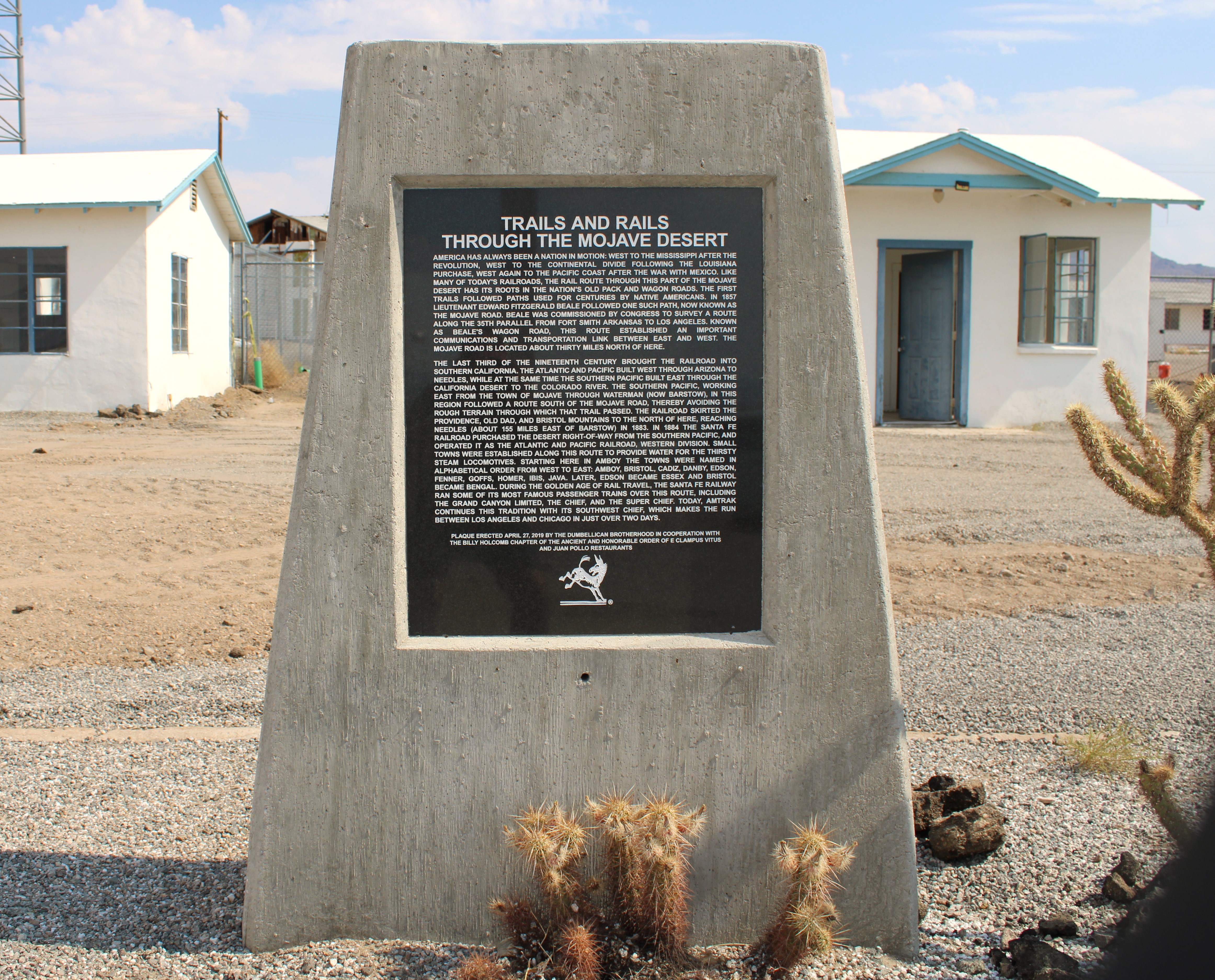
“When Albert passed away in 2023,” Ken said, “I wondered what would become of his dream of turning this once vibrant town into a go-to destination for those traveling along Route 66.”
Albert Okura, the founder of the popular restaurant chain Juan Pollo in Southern California, had purchased the nearly forgotten town of Amboy in 2005. Albert loved history, especially the history of Southern California and more importantly Route 66. When he purchased the town of Amboy, his wish was to do all he could to turn it back into the iconic spot where travelers from across the United States would stop along America’s Highway during its heyday.
 |
| The original sign is lit up nightly in Amboy, CA |
Albert knew he could recreate the thrill of travelers along Route 66 that was once felt after the route was completed in 1926. Sadly, Albert passed away on January 27, 2023 at the young age of 72 in Ontario, California.
But, his dream did not die. “His family have been wonderful in keeping Albert’s dreams alive here in Amboy,” Ken said. “Take a walk around and see for yourself all the construction being conducted to complete this place by the summer of 2026.”
That summer would be the 100th anniversary of the completion of Route 66, and there are huge plans being developed along that long river of asphalt stretching from Chicago all the way to Santa Monica.”
Rumor has it that a family of Sasquatches may attend the festivities somewhere along the nearly 2,500 mile highway - but of course, that is on a need-to-know-basis.
And, I need to know!
Before I started walking the property, Ken did inform me that finishing the entire project may be a bit of a stretch but “...knowing Albert’s family as I do, I think we may indeed have everything up and running for the huge crowds that will be coming through. They are an awesome group of folks and I am sure keeping Albert’s legacy alive will be in the forefront of their thoughts.”
I’ve been through Amboy more times than I can count - either heading east or heading west. Did I stop each time? No, but every time I passed by those stark white empty cabins, the large paned windowed reception area of the motel, and the gas station with its huge sign out front welcoming visitors, I felt a slight tug at my heart.
 |
| Road monument with unfished cabins in the rear at Amboy, CA |
The last time I visited and spoke with Ken, a large tour bus had just pulled up and about a million tourists exited. It was a very large custom made bus.
“We sometimes get up to three thousand people visiting a day,” he said. I just saw a million, so I suppose his math could be accurate, rounded off for the year.
As I was taking a snap of some of the construction going on, a tourist walked to me and in a very German accent and said he recognized me.
“Yes, I am John R. Beyer, the world-renowned travel writer,” I humbly responded.
“Nein,” he retorted. “You look like the restroom attendant. Paper is needed in stall three.”
I nodded and then mumbled, “You probably meant number two.”
Ken advised me that 50% of the visitors are European, 35% from the United States, 10% from South and Central America and the remainder from Asia or perhaps the territory of Nauru.
As I wandered here and there, teams of construction personnel were wiring this, harnessing that, and pretty much doing what construction personnel did. They were busy rebuilding Amboy into what Albert Okura had imagined.
 |
| New construction in the works in Amboy, CA |
In fact, in keeping to Albert’s plans, Ken explained that they hoped to have rooms ready to rent, a fully functioning restaurant, and other amenities which made staying in Amboy for more than a couple of hours a reality.
I asked about the family and their thoughts about Albert’s visions.
“I must say that Kyle, one of Albert’s children, comes here quite often and spends long weekends checking out how much work is getting done. Often, Mrs. Okura and other family members accompany him and they love it out here. They are a great and loving family.”
Years ago, my lovely wife Laureen, along with one of our daughters, Kelly, drove through Amboy and were delighted to see the site was being used as a Fly- In. Planes of all makes and models were actually landing along Route 66 and taxing to the small airport located there.
Music, food, and other entertainment were in abundance for all to share in.
Other events which are being coordinated by Ken, the other staff members, and the family are motorcycle rendezvous, classic car shows, airplane fly-ins, music festivals, space alien conventions, and the list goes on and on.
 |
| And gas is available at the original pumps |
Recently a Polish singer by the name of Daria Zawailaow utilized the town for a music video. It is spunky, riveting, and I have no idea what she is singing about - my Polish is rather limited except for some old and now inappropriate jokes.

The below link will show just one of the musical talents who visited Amboy and wanted to share with their audiences what an iconic place this little town is and why it is important to visit.
https://www.youtube.com/watch?app=desktop&v=CoMFkWwevjA
For more information: https://visitamboy.com/
John can be contacted at; beyersbyways@gmail.com