Pages

Showing posts with label Paul Bakas. Show all posts

Monday, October 25, 2021

Is the Mizpah Hotel haunted?


A few years ago, Laureen and I drove through Tonopah, Nevada on the way to see one of our daughters in Idaho. The town was founded around 1900 when a rich silver deposit was located in the nearby hills.
And that silver was founded by nothing more than serendipitous luck. 

Turns out that a miner, Jim Butler, was looking for a lost burro and had to spend the night hunkered below a rock outcropping. The next morning he located the burro, and picked up a large rock to heave it out of frustration.

“Wait,” he is rumored to have said to himself. “This rock is plenty heavy. I think I will have it assayed instead of just chucking it.”

In fact, that certain rock started the second richest silver strike in the state’s history, only behind the Comstock Lode near Virginia City.

Tonopah is the county seat of Nye County and is about midway between Las Vegas and Reno at the junction of U.S. Route 6 and U.S. Route 95. It’s a small town of just over two thousand folks, according to a 2019 statistic from the US Census Bureau.

We could only stay a couple of hours but learned a few things about this little berg during that time.
Wyatt Earp arrived in 1902 and opened the Northern Saloon. Hugh Bradner, the physicist, invented the neoprene wetsuit had lived there. Tasker Oddie, the 12th governor of Nevada and United States Senator lived there. And, Dennis Avner, also known as the Stalking Cat died in Tonopah in 2012 – he was the guy who had fourteen facial surgeries (body modifications) to make his face look like an actual feline.
So, there was a lot to this town – and, it is haunted.

Words can not explain this - really!

According to tonopahnevada.com, the whole town has ghosts and goblins hanging around.
There’s the prank loving ghost, George ‘Devil’ Davis, who plays gags on people at the Tonopah Liquor Company.
 
Then there is Bina Verrault, who left New York City under nefarious reasons, and ended up dying in Tonopah – she loves to stare out the windows of the Tonopah Historic Mining Park’s visitor’s center.
Then there is the cemetery which is haunted right next door to the infamous Clown Motel. Strange lights, full body apparitions, and weird noises can be heard coming from the cemetery.

Tonopah cemetery, next to the Clown Motel

But, isn’t a clown motel creepy enough without worrying about supernatural goings-on in the grave yard?

“Dad, I think that clown opening our door has a machete in his hand.”

“Not to worry, son, I’m only concerned about white orbs floating menacingly about the Old Tonopah Cemetery.”

And, according to USA Today 10Best Reader’s Choice Award in 2018, the Mizpah Hotel in Tonopah, Nevada was voted the most haunted hotel in America.

Hotel Mizpah, Tonopah

So haunted, that many paranormal professionals have visited this town in the south-western part of Nevada to investigate the numerous sightings of things with no explanations.

This hotel really has tales to tell.

Three of the most famous other-worldly residents at the hotel is the Lady in Red, who was stabbed and strangled between rooms 502 and 504 on the fifth floor. Then there are some children who are heard and seen running around the third floor and then just disappear into thin air. And finally, a murdered miner or robber hanging around in the basement – not really hanging there, more like, just hanging out.

Lady in Red suite at the Mizpah Hotel, Tonopah

“We’ve got to come back and book a room on the fifth floor,” I stated to Laureen, as we sauntered through the lobby of the gorgeous hotel.

The Mizpah Hotel was started in 1907, and was going to be the center-piece for the entire region. Architect, Morrill J. Curtis designed the large hotel and for a cost of over two hundred thousand dollars when completed in 1908, the town had their grand hotel.

It had fifty rooms, two restaurants, a bar and other rooms for meeting and social functions. Everything went well for the town and hotel, but like most mining communities, there is always an end to the gold and silver ore bonanza. By 1920 the population had dwindled, with miners looking for the next big strike.

Tonopah hung on with the induction of dollars from the military from the Tonopah Test Range, which was also used for the development of the F-117 Nighthawk. In 2014, a solar energy company dumped millions into the economy by constructing a solar plant nearby.

But, there wasn’t quite enough business to keep the Mizpah Hotel from closing, which it did in 1999 and fell into disrepair. An enterprising couple, Fred and Nancy Cline bought the vacant hotel for two hundred thousand dollars and retrofitted it to its former glory.

They did a marvelous job.

As we walked around the hotel, it felt as though we had stepped back more than a hundred years in time. The lobby, the reception desk, the wide stairways, and every other area in the hotel is painstakingly stunning.

Lobby at the Mizpah Hotel in Tonopah

We had to stay – but we didn’t. Time was not on our side that trip, but we made a vow to spend the night in this haunted place the following year.

Nope, Covid-19 struck and that idea floated away like a paper boat in the gutter.

Well, on a recent trip through Nevada, sans Laureen – her schedule is a lot busier than mine – our friend, Paul Bakas, and I decided to see if the hotel is really haunted.

I contacted one guy, who I knew could give me the information I needed for this venture, and I got more than I needed to book a room at the hotel.

According to Cody Dare, from the paranormal investigating team of New Reality 11, they had a lot of action while filming a television episode at the Mizpah Hotel in the spring of 2021.

Cody Dare and his partner Shawn Warren on an investigation

“The basement is no joke. There is an old miner down there, very tall and very territorial. Lots of activity there. Lady in red, we didn’t catch much, but we did feel her presence there.”

I nodded at Paul. “I’m booking room 504.”

He was silent for a moment. “That’s kind of creepy. Trying to sleep in a room where there may be a ghost wandering around.”

“It is cool,” I returned.

Unfortunately, the room wasn’t available, and had a waiting list of about a year, according to the front desk clerk, Brittany.

“Everyone wants that room,” she said. “Weird, how people would want to sleep in a room a woman may have been killed in or near.”

“Yeah, that is weird,” I replied. We got a suite on the second floor and I put Laureen’s name on the waiting list.

All this ghost talk got me thirsty, so we stopped at the long dark polished wood bar on the first floor of the hotel for an adult libation.

Gorgeous bar in Mizpah Hotel in Tonopah

Alex, the bartender then shared some ghostly history of the hotel. There was plenty for at least two rounds of libations, we weren’t driving.

“I don’t believe in that stuff,” she stated. “But, I’ll tell you, I don’t like going into the basement.”
“I know, all those stairs going down that you have to come back up again,” I replied.

“No, that’s not what I meant,” Alex said. “There’s just this strange feeling I get down there. As if someone is watching me. I usually ask someone else to get whatever I need, so I don’t have to experience those feelings.”

Cody Dare was correct, there was a lot of activity in the basement.

My plans were solid – stay up and be on the watch for anything out of the ordinary.

I spent the evening sitting in the large and wide hallway outside of the room, but no ghosts or paranormal activity greeted me. After midnight, I called the investigation over – I was tired.


In the morning, just prior to our leaving, we headed upstairs to the fifth floor, to snap some photos of room 504. I brought my phone, since it took excellent photos. Just being past six, no one was stirring, not even a mouse.

Stairwell at the Mizpah Hotel, Tonopah

I shot a few photos – looked at them – and felt the hair stand up on the back of my neck.
“Look at this,” I stated to Paul.

As I ran wiped back through the five shots I had taken of the door, there was nothing but a tenth-of-second view of the door and then the screen went blue. Each and every one of the photos.

“I think you may have shot a video too,” Paul said.

So happened I had, a short one by accident. The hair went even higher on the back of my neck.

There was the door, with a greenish hue plainly seen at the bottom of the door, and then a loud crashing sound.


No one in the hall, but a loud crash and light below door

There was no one else in the hallway but Paul and me. 

“Did you hear anything when I took those photos?” I asked.

“No, but I think it’s time to go,” Paul replied.

It was and we did.

Did I witness a paranormal activity? I don’t know, but just before heading downstairs, I took another couple of photos of the hallway away from the door, and not an issue. Each one came out clear and bright.

Is the hotel haunted? Again, I don’t know but when Laureen’s reservation comes up next year – perhaps we’ll find out.


Monday, May 10, 2021

Take a hike - up and down ladders

Paul watching where he steps

My friend, Larry, asked if I had ever heard of the ladders. I thought that was a strange question, since I’ve been climbing up and down ladders all my life. I should have known better when Larry speaks, the question might require deeper thought.

“You mean, like when Laureen wants a different pair of shoes from the top of our closet? Sure, usually I need an extension ladder. It’s a very tall walk-in.”

“No, I mean the hike through the Painted Canyon Trail near Mecca.”

I shook my head. “Nope, that doesn’t ring a bell, and I’ve been on hikes that you can actually ring a bell at the top of the trail.” Admittedly, a cheap plug for an earlier article I wrote for the Daily Press, concerning Bell Mountain in Apple Valley.

“You need to go,” Larry responded.

No need to ask me twice, unless I wasn’t listening – like I do with our children. If Larry said to go hike this place outside of Mecca, then I would do it.”

“He didn’t mean Saudi Arabia,” Laureen stated. “He’s talking about the town of Mecca by Salton Sea. We’ve been there.”

 “I knew that,” I said, while secretly sticking my passport into my back pocket. 

Turns out, that the Ladder Canyon and Painted Canyon Trail is one of the most popular destinations for outdoorsy people in Southern California. 

According to Alltrails.com – ‘Ladder Canyon and Painted Canyon Trail is a 4.9 mile heavily trafficked loop trail located near Mecca, California that features a waterfall and is rated as moderate. The trail offers a number of activity options and is best used from October until April.’

The reason the trail should only be hiked until the end of April, is that after that – the sun happens to be about thirty yards off the ground in the low desert.

Yes, in April and possibly May, the hike near Salton Sea – which is minus two hundred and twenty-six feet below sea level – is doable. But, like most desert communities, come June – hiker beware.

Looking west from the rim toward Salton Sea

‘Hiker beware’ means that if you venture out into a furnace, and the only floor you have is radiating sand, then the sunscreen you lathered on only means it will take a bit longer for you to bake.

A serious note - always be aware of your surroundings when outdoors. Bring plenty of water, wear a hat, have sunscreen on exposed skin, and check the current weather in the area you are planning on hiking. Mother Nature can play dangerous games on those less observant of her rules. 

“It’s not that hot.”

“I can’t hear you, my ears just melted off my head.”

Be careful out there – sounded like a PSA, didn’t it.

Okay, do I ever take these precautions to heart? Of course not, my job is to go out and find places to visit and tell others about them.

I’m a professional – that usually means, I do stupid things to get published.

“So, when are you going to hike this trail?” Laureen asked.

“I was thinking mid-August, when the temperature would be equal to that on Venus.”

Then our friend, Paul and I decided the end of March would be a better time to hike the Ladders trail. 

The directions to reach the trailhead are easy. Drive south out of the city of Indio on Highway 111 (also known as Grapefruit Boulevard) for about sixteen miles, enter the small town of Mecca (not to be confused with the one is Saudi Arabia), take a left at 4th Street, turn right onto 66th Avenue and then just continue in an easterly direction until reaching Painted Canyon Road. Painted Canyon Road is a four mile dirt road that heads to the trailhead – well paved, and even though some sites state a four-wheel drive vehicle is best (and when aren’t they?) any mode of transportation, except a skateboard, should be able to make the passage. Though, about a quarter of a mile from the trailhead, there is a bit of deep sand, but the cautious driver should not have any issues – unless there are flashfloods, haboobs, earthquakes, or an asteroid strikes.

“It was easy getting here,” Paul stated, as I parked the truck.

I nodded. “I may just put in the blog how easy it was to get here.”

Donning our gear, mainly a water pack, we were ready to start hiking. Even though it was early on a Monday, the trailhead already had a dozen other vehicles parked. Another serious note, when hiking in the desert, no matter the time of year, always try to get an early start – just because the weather says the high will be seventy degrees doesn’t mean it will be a pleasant stroll through the landscape. If there’s no shade, seventy in full sun can be intense – thus, the reason for plenty of water and a hat.

At the trailhead, there was a map of the hike, I took a photo of it, but Alltrails.com had one that I also had downloaded.

“Let’s do this,” I stated, while starting down the sandy trail toward the narrowing canyon walls.

“We’re hiking, not robbing a bank,” Paul stated. “Let’s do this! OMG, we’re following a well-worn path.”

It’s best to ignore Paul early in the morning. He can be a little grumpy.

The first quarter of a mile is through a river bed with deep soft sand, before reaching a large arrow on the ground made out of river rocks pointing to the left. There, a large rock fall marks the first ladder to be used to clamber up through a narrow slot canyon.

Yes, real metal ladders are used to go from one section of the canyon to the next, along the trail as you gain about five hundred and sixty feet in elevation to the top of the rim.

John climbing on of the many ladders

The canyon trail meanders right to left and then left to right, and are tall and narrow. At some points, I had to turn sideways to make my way through, especially after climbing up a ladder and squeezing through the opening at the top.

Paul navigating one of the trickier sections with a ladder

According to hiking-in-ps.com, ‘The Mecca Hills (where Painted Canyon Trail is) were formed by the convergence of the North American Plate and the Pacific Plate along the San Andreas Fault. The geologic formations of Mecca Hills are among the most unusual of their kind in the world.

I determined that “some of the most unusual in the world” was a great description as we hiked through the multi-colored canyons with towering rock walls reaching upward to the blue sky. It was eerie to walk through this natural labyrinth. One moment the sun would be streaming down through the narrow slits above us and then it would be gone, leaving us in an almost twilight darkness.

The narrow canyons wind their way through the area

The shapes of the walls constantly twisted here and there. Various shades of earth greeted us at every step, as if an artist had spent time creating these colorful designs on the canvas of the walls.

Again, according to hiking-in-ps.com, ‘Layers of eroded rock, some over 600 million years old, have been pushed up and overturned by the activity of the San Andreas Fault system.’

It is awe inspiring to see how the violence of the early earth created such dramatic backgrounds for us to witness.

The Ladder Canyon and Painted Canyon Trail, is such a place.

Being a loop trail nearly five miles in length, gives the hiker a lot to view. Beautiful canyon walls, brilliant rock surfaces, tall Ironwood and Smoke trees, and one of the best views of the Salton Sea to the southwest from the top of the rim there could be.

The trail is rated as moderate, but with a steady gait, the hike can be completed in three hours. Of course, it may take longer when stopping to snap a photo of this and that – and there’s plenty of this and that to snap photos of along the way.

Hikers have claimed that Bighorn Sheep frequent the area, along with desert wildlife such as spotted bats, desert tortoises, and prairie falcons. 

We saw ravens.

Even though there seemed to be a lot of people hiking the day we made the trek, there were no lines at the nearly half a dozen ladders, but weekends can be crazily busy with long conga lines forming at the bottoms of the ladders.

If a person is not in a hurry, then what’s a little wait now and then? Relax, join the dance line and enjoy the wonders of Mother Nature.

Paul's arm shows it's not only the heat that can hurt you


Friday, November 29, 2019

Expect the Unexpected...


There are times when we may want to go out and simply stare up into the skies -- to regenerate, and marvel at the heavens. The universe is a pretty big place, but looking skyward from a city is sometimes a little disheartening. Too many city lights often block out the millions of stars staring back at us.
There's lots of action going on up there
A dark sky locale is generally called for. No distractions from artificial lights -  just out there in the peace and quiet of the night. Oh, and did I mention really dark?

Such a place is Pisgah Crater. 
 
Pisgah Crater is located in the Basin and Range Province, in the Lavic Lake volcanic field – which means, there’s a lot of ancient lava flows covering the desert floor near the crater. These flows span for many square miles, and in fact, can be easily seen from Interstate 40 or historic Route 66, at about the halfway point between the city of Needles (hometown of Spike, cousin of Snoopy), and Victorville, California, not far from where we make our home. 

Pisgah crater - viewed from the north 
Geologists believe Pisgah may have last erupted somewhere between 20,000 to 50,000 years ago, but there are disagreements about the exact date, even among the experts. Some argue that it may have erupted as little as 2,000 years ago. But, since the Amboy Crater, 54 miles to the east of Pisgah, last erupted about 18,000 years ago, it would make sense that Pisgah probably emptied its magma holdings around the same time. It’s much like how one earthquake can trigger a nearby fault causing a neighboring quake – one close volcanic eruption, can begin another volcanic eruption.

The Pisgah cone once stood at 2,638 feet, but now measures 93 feet shorter, at 2,545 feet. This reduction in height was caused in part by some natural weathering, but also by the impact of mining. It is privately owned by the Can-Cal Resources Limited, a Canadian company which mined the crater for railroad ballast for the Santa Fe Railroad. It appears that mining has not occurred for a few years from the lack of any structures or mining equipment on site.

Though it is private property, easy access proves a boon to many colleges and universities for weekend geology classes. Also, it seems the area has been used in films, music videos, commercials and much more.

The point being: when traveling, always expect the unexpected. 

Approaching the almost totally black volcanic cone one late afternoon, I noticed a number of semi-trucks and trailers parked on a large flat section on the west side of the cone. Suddenly, a helicopter buzzed above and made a daring swoop to the ground and then simply posed in mid-air. Hanging like a hummingbird looking for a feeder.

Why are these trailers on 'my' crater?
“What is going on?” I asked.

Truly, what is going on here?
“A helicopter is hovering,” Paul Bakas replied, my old friend who travels with me when my lovely spouse, Laureen, can’t make the trip. “Now, I think it’s backing up.”

The pilot was outstanding - swooping here and there - feet above the crowds
As we drove up the winding road to the flat surface of Pisgah, we knew instantly that this night was not going to be one of the dark nights, so desired for stargazing.

On the west side of the crater, dozens and dozens of people were milling around, dressed perhaps as aliens, or natives from another time. Skin colored body suits with black stripes over their arms and faces. Some wore outlandishly colored masks.

One woman we met named Lola, informed us she was an extra in a Latin rock video and her job was to walk toward the band as they were playing near the precipice of the volcano. As if the extras were being drawn to the sound like magic.

That sounded very musicesque (I made that term up). The band was there, performing on stage, but no music could be heard. Perhaps, a huge helicopter swooping here and there over the set filming, may have been the reason.

When asked the name of the band, Lola simply replied “I don’t know,” as she walked away in her body suit and painted face, towards the other extras.

Lola - the photo was posed - those actors!
Paul wandered around. He tried asking a limo driver, a food truck owner, anyone who could find, if they knew the band’s name.

“All I got was a Latin rock band,” he told me. “Weird, I asked twelve people.”

“A non-disclosure agreement for everyone?” I asked.

“I’m not a lawyer,” he responded. “But I think you just made that up.”

We watched, after setting up camp, as the actors marched down the hill toward the band and then back up the hill for another take.

Well, not only was the music blacked out, but so was the sky from the stage lighting. Not what we expected for a dark sky night looking at stars. But sitting in camping chairs and watching the action was pretty entertaining.

Always have a plan ‘B’, when plan ‘A’ doesn’t work out. No star gazing perhaps, but the next morning, hiking around the crater proved to be an almost surreal experience. Black sand beneath our boots seemed as though we were walking on another planet.

When time allows, send home a message to a loved one - that would be Laureen


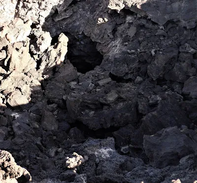
Lava tubes opened up in front of us to be explored (note of caution though, these ancient tunnels where lava once flowed can be dangerous – extreme attention must be stressed).

Lava tubes, deep and long - caution is desired for falling rocks
Pisgah crater is a place to be visited – it’s even a great area to fly a kite. I did, why not?


Go fly a kite! Really, just fly a kite - it's fun.


Sunday, September 15, 2019

Two Rivers Run Near-By

On a recent trip to Meridian, Idaho, to visit daughter Kelly, and son-in-law Travis,  our buddy and trusty cameraman, Paul Bakas came along for the ride. Well, from our humble abode, the ride was a little over 13 hours, non-stop. Laureen could not make this particular trip, due to conflicts in her work schedule, so it was up to the two boys this trip.

"Are you're sure that you both can go and not get into trouble?" she asked, a week before our departure.

I recalled, being in Pamplona, Spain, during the annual bull run, many years earlier, made famous by the great American author, Ernest Hemingway, and that hadn't worked out for the best. No I didn't get gored, but I'll never forget the breath of one bull running a lot faster than I was. I jumped over a short fence to safety. The man in front of me - well, one horn taught him a lesson.

"We won't get in trouble," I reassured Laureen.

And, we did not. The drive from Victorville to Meridian (a city nestled next door to Boise) was an easy one. Long, but easy.

This was not just a chance to visit with  Kelly and Travis, but we were to partake in two separate river excursions. Running the white water of the Payette River, with an experienced guide and then the next day, floating the calm and easy Boise River in an inner-tube.

The Crew: Kelly, John, Travis, and Paul taking the photo
Running the Payette River, is never to be taken for granted. Helmets, life vest, paddles, and a strict lecture, given by our guide, Lee MacDonald Pownau, to whom we nearly had to swear our souls.

"Where does rafting happen?" drill sergeant Lee asked.

"In the river," Paul replied.

The look Paul received from Lee was unnerving. I turned my head away. "It begins and ends in the raft. Without the raft, there is no rafting."

Captain Ahab - no, Captain Lee 
Actually, I was thinking, if there was no river, there wouldn't be the need of a raft. I remained silent, afraid my helmet, life vest, and soul would be lost to the churning waters upon which we were about to embark, if I disagreed with Lee.

We pushed off, and immediately took to the river like fish running for their lives. The next few hours reminded me of the time when I was a law enforcement officer. Most of the time, it was just a job taking reports, but - and this is a big but - there was about 5 to 10 percent of the time, it was stark raving crazy.

The raft behind us - the river can be tricky

"Paddle forward," Lee barked, and I wondered what the big deal was. Well, going over a six foot waterfall of bone crushing water was a big deal. The five of us, on our raft, paddled like people being chased by demons.

A rather relaxed section of the Payette at this time

According to Lee, the Payette was actually down quite a few feet from it's high mark in mid-June. That's when things can get dicey. It was dicey enough, and when we came ashore near the town of  Lowman we were all tired from paddling and looking for holes in the river (a term for river runners that would conjure doom).

Lowman is a very small settlement, situated in the mountains, about two hours north-east of Boise.

The owners of the Payette River Company, Sean and Ginger Glaccum, have a wonderful business, that not only allows people to raft along the Payette, but have experienced guides, who also know the history of the region.

With Lee, there was so much to learn, and he didn't scrimp on sharing his knowledge.

It was great river run: some scary rapids and some nice long runs, along placid clear blue water, allowing us to chit and chat. What more could one ask for?

The next day, it was off to the near-by river, the Boise, for the annual float enjoyed by locals and tourists alike. Very different from the previous day: no one was hanging on for dear life, hurtling down white water waterfalls. No, this was to be enjoyed by all ages.

The difference was surreal.

Floating down the Boise does not require lectures from expert white water guides. It's about having fun on a sunny day with family and friends. Utilizing inner tubes, flip-flops, and water proof cameras  is all that is required. The ride starts near a pub knocking back a couple of cold ones. We started off at Payette Brewing, just a few steps from the Boise River. A couple of toasts and then a short walk across the river to a waiting bus. A few bucks, and the bus dropped us off at the start of the float fifteen minutes later.

From there, it was simply laughing, laughing and laughing some more. No huge waterfalls - though, there are a few sections of speedy water, and a person could get tossed from their floaty if they aren't observant.

Kelly looks like she's struggling on the river, not!
 Looks more like a model.

Travis is wondering, why his beer hasn't been delivered. 


Paul, struggling through the treacherous waters of the Boise River
 - hang on Dude!

The city of Boise, only allows a certain time to float the Boise, due to weather conditions. When Laureen and I were there in early June, rafting wasn't allowed. The water was running too quickly and far too cold.

July and August are the months to enjoy, stretching out on an inner tube, or raft and enjoying the peaceful serenity of the currents.

The end of the trip winds up where we started, across from Payette Brewing and how perfect is that? Start with a brew and end with a brew.

Life couldn't, in this writer's opinion, be better than that.

When in Idaho, explore the rivers - and if there's enough courage - run one.

Love the water and the water will love you.

Photographs by: John R. Beyer and Paul K. Bakas

Friday, June 7, 2019

Mount Rubidoux


One of the entrances for the trail up Mount Rubidoux
Spending roughly three decades in Riverside, John knew the iconic landmark, Mount Rubidoux intimately. During his three months in the police academy for the Riverside County Sheriff's Department, he, along with the rest of the cadets, used to run the three mile asphalt road which led to the top of Rubidoux. The run wasn't that difficult, since the cadets were in good physical shape, but it was the yelling by their drill sergeant which caused the pain during the run.
Maybe it wasn't Sgt. Carter but someone was always yelling at the cadets
So, when John and Paul Bakas, decided to head to Riverside and hike up Mount Rubidoux, memories of the 1331 foot mountain flooded fondly back.

The winding black asphalt rolled out in front of the two casual hikers; the route up and around Rubidoux is an easy hike, as was evident with moms pushing strollers and older folks strolling while talking about this or that with their friends.

Paul, looking back and wondering: are we hiking or taking photographs?
Not being strenuous, allowed a good deal of time to soak in the beauty of the valley which holds the city of Riverside. The San Gabriel Mountains to the northwest, the San Bernardino Mountains to the southeast, and the San Gorgino Mountains to the east lock in this city of nearly  330,00 people. The sights from along the roadway are picturesque and the multitude of people walking, running, bicycling the path seem to enjoy the views immensely. People stopping here and there to snap a selfie or take a photograph of the scenery proved that this venture was appreciated.
Yes, staged pose of John
A wooden bridge which intersects two different routes
View, eastward from half-way up Mount Rubidoux
Looking north from the cross base toward the American Flag
The former name of Mount Rubidoux was Pachappa. The mountain was once part of the Jurupa Rancho, which had been granted to Juan Bandini in 1838 by the Mexican government. As the Rancho expanded, Pachappa was reassigned to a smaller hill to the southeast as the boundary marker for Jurupa Rancho

In 1906, Frank Miller, of Mission Inn fame (written about in a previous blog), along with Henry E. Huntington and Charles M. Loring, purchased the mountain with the idea of building a road to the top of the mountain. The view, they believed, would be a wonderful gift to the city of Riverside.


And it was.

Looking east from the top of Mount Rubidoux over downtown Riverside
The mountain is well known for having Easter Sunrise services at the top with thousands of people venturing up the long and winding road to listen to a non-denominational service. At the sunrise service in 1912, an estimated crowd of 3,000 people attended and by the 1920's, the crowds had grown to over 30,000. It was an event known around the country with people coming from many different states to take part in the early morning trek on Easter to the top of the mountain.
Easter Sunrise Service - 1920's. John is third from the right on last step
It is believed, the Mount Rubidoux Easter Sunrise Service became the catalyst for many other locations around the United States, and the world.

Even the Hollywood Bowl got into the act after Riverside
As a honor to Father Juniper Serra, a gigantic white cross was erected at the very top around 1907. But a snag was put in place one hundred and five years later in 2012, when the group, 'Americans United for Separation of Church and State', took the city of Riverside to court. The anti-Christian group, wanted the cross removed from public lands, as it may offend non-believers.

The 'Cross' - oh, that 'Cross'
 In a meeting in January of 2013, the city council decided to sell the cross and the approximately 1/2 acre of land beneath it, thus making it no longer public land.

'Totally Mt. Rubidoux' was formed, and won the bidding at $10,500. The group was sponsored by the Friends of Mount Rubidoux and others, which raised in total, over two-hundred and fifty thousand dollars. There was plenty of money left over when the bidding stopped to ensure the area around the cross was taken care of for good.

The people were speaking loud and clear!
The city of Riverside played a serious legal battle to maintain the cross on top of the mountain, which has and does call tens of thousands of believers every year. The anti-Christian group, was not happy - but, hey, where there's a will there's a way, and Riverside found the way to preserve a portion of it's history.

I didn't win - I have to win - listen to me!!
 The road to the top is an easy hike and the views fabulous, the history fascinating, and the idea that a public government would stop at nothing to ensure a cross stays put for their community is awesome.

So, next time in Riverside - take a few hours and climb up to the top and see the valley. It's worth the time and effort.