Pages

Showing posts with label Mojave Desert. Show all posts

Monday, April 1, 2024

Garlock - the lifeblood of Ransdburg


Welcome to Garlock

Starting in Hesperia and extending all the way north to the Oregon border, runs a wonderful highway most are familiar with - the 395. From the dry deserts to the  snow-covered Sierra Nevadas, this 567 mile trail of black asphalt has everything a traveler could wish for in terms of expectations.

Vast tracts of vacant land with wildlife for visitors to view and enjoy. Lakes for fishing, boating, or just relaxing next to. Miles of hiking trails begging for the adventurous to tug on some boots and explore.

Highway 395 is a wonderful road to drive and experience, no matter the season.

The author Robert Louis Stevenson stated; “I travel not to go anywhere, but to go. I travel for travel’s sake.”

I find myself in that same mental state quite often. Of course, my lovely wife Laureen may believe I might be in another state of mental wellness - but I’ll keep that between myself and the little green men inhabiting my cranium at this time.

Driving north or south Highway 395 is always a joy. Small locales like Randsberg, Lone Pine, Bishop, and others come to mind but often it is right off the well traveled highway to the byway where other adventures await.

Recently I took one of those byways and made my way to the ghost town of Garlock, approximately nine miles west of Randsburg.

Ghost towns are wonderful experiences for the visitor. To wander where folks had made their hopes and dreams come true, even for a short period. We humans have this endearing quality that makes us believe in our dreams and pursue them. If we hadn’t, the moon would still just be a large bright thingie that circles our earth.

Things to see in ghost towns - Garlock, CA

I first heard of Garlock years ago during a conversation I had been having with another traveler. But honestly when the gentleman mentioned it to me years ago, I actually thought he was talking about garlic - he had a lisp in all fairness.

“I use a lot of garlic, that’s why we don’t have vampires around our home,” I replied.

He looked at me, shook his head and walked away.

“Seriously,” I said. “Not one.” 

Taking the advice from my fellow explorer, I decided it was time to actually visit the town in Kern County.

The ghost town has a very interesting history, as do most places, but this one was created for the benefit of other small towns nearby.

Garlock was originally known as El Paso City, after the small mountain range nearby, and then later as Cow Wells, since this is the area where many cattlemen and freighters would stop to obtain water for their cattle. The only other local place available was the wash of Red Rock Canyon which could be very dangerous during certain times of the year - especially monsoon season.

In the late 1880s some small traces of gold were discovered in the El Paso range and then in 1893 a gold nugget worth $1900 was found near Goler Heights and the rush was on. That amount would be approximately two gazillion dollars today. No wonder prospectors were tripping each other with their picks and shovels.

“That’s my claim,” one prospector may have yelled at another as he raced flat-footed across the desert landscape in search of his riches.

With an evil laugh, the other prospector stretched out his shovel. “And I claim you just done fell down on your noggin.”

In 1894, gold was being located all over the place and Eugene Garlock, a very successful businessman who was living in Tehachapi at the time, decided that it would be a good venture to set up a stamp mill in the growing small town. 

And that’s what he did.

An eight stamp mill was built and miners from all over the territory utilized Garlock’s ingenuity. In fact, the town started to have name changes - first miners would say they were going to the ‘Garlock Mill’ then ‘down to Garlock’ and finally just to ‘Garlock.’ The name stuck and the previous ones went the way of the desert sands - blowing into the wind.

A historical marker erected in 1958 allows the traveler to know how important this once booming town once was: ‘NO. 671 Site of the Town of Garlock. In 1896, Eugene Garlock constructed a stamp mill near this spot to crush gold ore from the Yellow Aster Mine on Rand Mountain. Known originally as Cow Wells by prospectors and freighters during the 1880s and early 1890s, the town of Garlock continued to thrive until 1898 when water was piped from here to Randsburg and the Kramer-Randsburg line was completed.’

A very important part of the history of this whole area, and worth a look around.

There’s not much there, but that isn’t always the point when venturing into an unknown destination. Just walking over ground that others in the past have tread is worth the effort of getting there. To take in a vision they had for their future and wonder what it was like in their past.

Most of the time, it is humbling.

I once met a person who asked why I would want to visit old ruins of a bygone civilization - I happened to be on my way to Greece at the time and could not wait to walk where Socrates or Plato sat and thought.

“Humanity’s past is what made our present,” I responded.

“What's a humanity?” she asked.

As I looked across where the town of Garlock once stood, I realized that the people who had lived here had created a life not only for themselves or their families, but for the surrounding communities as well.

It was mid-morning when I found myself treading across Garlock Road investigating this and that of what was left of this town. As I stated earlier, not much, but there are signs which tell the history of the place as well as ones that tell the onlooker not to trespass across the chain link fences guarding the few remaining original structures.

Always respect the signs at historical sites

But, unfortunately one building had been graffitied with the typical nonsensical scrawlings of a person desperately hoping someone can figure out who had been there.

Since this is a family blog, I will not write what kind of person would desecrate a historical site in my opinion.

The other structures are intact, though years and weather have taken their toll - as those same years and weather have taken their toll on the guy typing this column.

Not bad after a hundred years - Garlock, CA

One area, behind a locked fence, seemed to be that of the original arrasta that was built during Garlock’s time to crush the ore on the premises.

Original arrasta in Garlock, CA

No one was present. In fact, not a single vehicle cruised by the entire time I was wandering around admiring the ruins available to see. Then again, right off of Highway 395, there were signs and a road block stating that Garlock Road was closed due to flooding.

Being a professional, I traveled the roadway to investigate if it were true. Nope, it was not. The road was dry as a bone, but caution should be taken when ignoring road signs. In fact, it is always better to take caution seriously since in the desert flash floods can occur at a moment's notice.

I did not tell Laureen I had abandoned logic on this venture.

Garlock had a functioning post office from 1896 until 1904, and then again from 1923 until 1926. The building which housed the government business was made out of railroad ties and can still be seen today, with a flagpole still standing proudly - absent the flag.

Railroad tracks heading southwest from Garlock, CA

Though the town did boast a population of several hundred during its heyday, delivering water and crushing ore and offering other services, soon other issues would spell its doom. In 1903 a stamp mill had been built in Randsburg and water had been piped to Randsburg and other close locations since the late 1880s.

Perhaps old water cisterns at Garlock, CA

Eugene Garlock passed away in 1907 and the town seemed to drift away as well into the pages of history. 

A school had been built in Garlock utilizing adobe for the walls. Later this structure was a store and rumor has it in the 1920s it may have served as a brothel and speakeasy for the local miners still managing to pull precious ore out of the ground in the nearby hills.

According to various sources, Roberta Ruth ran a curio shop in Garlock until the 1960s.

I ate lunch along the Redrock Randsburg Road and almost could hear the old wagons creaking by carrying water east toward the bustling mining town of Randsburg. It was probably just the slight breeze in my ears.

Then again . . .


Monday, December 26, 2022

Fun With the EP-2 Fat Tire E-Bike

Just doing what I do, traveling

As a travel writer, I travel. That’s what I do, visiting many varied places during those times when I am out and about. Sometimes in the hustle and bustle of large cities and sometimes, other times, as I prefer, in the hinterlands of a desert landscape or on mountain paths. 

Traveling the byways, as I do, I am always cognizant of my mode of transportation. Will I need 4-wheel drive to get to a ghost town? Will I need to bring hiking equipment to climb to a vista point? Getting to out-of-the-way places can sometimes be a challenge.

So when I was contacted by ENGWE, manufacturer of various models of folding e-bikes, to see if I would be interested in testing and reviewing the EP-2 Pro Fat Tire Folding Mountain E-Bike, I jumped at the chance.


I had already been planning a trip across the Mojave Desert in Southern California and what better place to put this bike through some serious trials with soft sand, hard packed trails, steep terrain, and all the rest which makes this desert a formidable place for the adventurer?

I advised the marketing rep to send the bike as though it had just been purchased by a customer. It arrived in a large cardboard box delivered to my residence.

What impressed me from the start was the way in which it was packaged. Styrofoam comforted every inch of the bike. There was not one scratch or damaged piece to be seen. It was a unique experience not to have to think of returning a damaged item.

The directions which came with the bike were clear and concise. It took a little more than a half hour to make the bike complete.

A tool kit was supplied which was useful for attaching the front and rear metal fenders, the rear rack, the front and rear lights, and everything else that needed to be attached or tightened.

Folding the bike was simple, a lever in the middle of the frame resulted in the bike folding nearly perfectly in two while another lever on the front allowed the handlebars to fold in, making it easy to load the bike into the rear of a vehicle. The bike fit perfectly in the rear section of my Toyota FJ, with room to spare.

No issues in carrying this E-Bike

The bike does weigh 74 lbs., which puts it at the top of most electric bikes but considering it is for rough riding, the weight should not be a factor in decision making.

The EP-2 Pro has a 960W Peak brushless gear motor, a 48V13ah Lithium Battery, 20” inch fat tires attached to a 20” folding aluminum alloy frame, disc brakes, iron leg shock absorbing front shocks, Shimano derailer, an easy-to-read 48v LCD screen on the handlebars, and so much more. 

The top speed is rated at 28mph but when running on smooth pavement I was able to reach 31mph. 

There are five levels of peddle assist for the EP-2 Pro and all kick in when certain peddling speeds are reached by the bicyclist.

Running through each assist level, I noticed a distinctive pull as the bike kicked into gear and felt confident that this e-bike would take me pretty much anywhere I was willing to attempt.

Laureen also enjoyed the EP-2 Pro

The seven-speed Shimano derailer with the convenient set-up on the right handlebar was easy to use and mastered in only a few moments. Shifting was fast, smooth, and kept in the sprocket no matter the ground I was traveling over or how I may have manually shifted the peddle assist in various locales.

Distance is rated at 50 miles, depending on speed and terrain. One afternoon the bike took me over a little more than twenty-five miles over rough desert roads. There were still a couple of bars left on the battery indicator, so this e-bike is good for at least 35 miles or more with an average sized rider atop it – again, depending on the traveling surface.

Overall, the EP-2 was more than I had expected. Great looks with its rugged black exterior, handling any terrain I put to it and appearing ready for any adventure.

For the price of roughly $1,000 makes this outdoor E-Bike more than reasonable for anyone wishing to pursue the great outdoors, be that city or country.

In all transparency, I was not paid for this review, now work for ENGWE, but was offered a chance to test it - and I did. It was fun.


Friday, June 24, 2022

Daggett - Worth a visit


Original Blacksmith shop in Daggett, Ca

According to Mark Staggs, President of the Daggett Community Service District, the small town of Daggett has big plans.

“We have big plans,” Staggs stated.

I have always had a soft spot for this little berg, ten miles east of Barstow on Interstate 40. I used the town of Daggett for one of my novels, Operation Scorpion. I spent some time there, doing research for the fictional piece, and met some really nice folks. 

But, since the publication, I haven’t been back. Sure, I drive by quite often, on my way to here and there along the interstate, but I rarely stop.

So, when I heard Staggs was giving a historical tour of the town, I knew it was time to revisit and learn more about the history of the town.

Staggs is a nice guy – truly nice. He immediately made our little group of tourists feel right at home. He is one of those fellas who likes to tell a joke, while being serious about the history of the town he truly loves.

“The history of Daggett isn’t known by a lot of tourists, but we are in the works to change that,” he shared.

Those are the big plans Staggs had mentioned earlier while conducting a fascinating tour of the Daggett Museum.

Old downtown of Daggett
For many, Daggett is not known at all. A dot on a map between Barstow and Needles along the black ribbon of a busy interstate. But back in 1939, with the publication of John Steinbeck’s novel, Grapes of Wrath, the small town got a mention. When the Joad family, from Oklahoma, drove through the inspection station just east of town, those refugees from the Dust Bowl had officially arrived in California.

According to the Daggett Historical Society, the town was founded in the 1860s, but did not become known as Daggett until 1883. At this time, the mines were running full steam in the nearby Calico Hills. The residents realized having the mining town of Calico near Calico Junction may be a bit confusing – so, the folks decided that the name Daggett may fit the bill, using the last name of then Lieutenant Governor of California, John Daggett. 

It is rumored, and don’t we all love rumors, that the Lieutenant Governor had visited Daggett at some time. 

Well, here’s something of note about Daggett which isn’t a rumor. Helen Muir, the daughter of the famous naturalist, John Muir, resided in Daggett. She was instrumental in assisting her father with his writings and correspondence, but being in poor health, the family moved her from northern California to the warmer climate of Daggett. 

Other visitors to Daggett during its heyday included Walter E. Scott – better known as Death Valley Scotty, Francis Marion Smith – better known as the Borax King, Tom Mix – better known as Silver Screen Cowboy, and Wyatt Earp – better known as ‘I get around the West a lot.’

There is a lot of history in this town.

One of the original water towers

After the museum tour, Staggs offered a hands-on tour of the area.

Actually, it wasn’t exactly hands-on, but more of a drive-by and get out of your vehicle sort of visit to the numerous historical sites in and around Daggett.

According to Staggs, there were quite a few indigenous peoples who had lived in the area, long before the settlers arrived looking for rich minerals or good lands for farming and grazing.

“People have been living here for thousands of years,” he stated. “In fact, the Vanyume, or Desert Serrano were some of the Native Americans first encountered by the Catholic missionaries in the late eighteenth century.”

As to point this out, Staggs had us drive approximately a mile or so to the north of Daggett, where, behind a tall chain link fence, was a huge pile of dark colored rock. Upon those rocks were dozens of petroglyphs. 


“We’re not really sure who created these glyphs, but we know they are hundreds of years old.” 

“I know they’re at least older than nineteen-forty-seven,” I replied. “Some local carved his name and date on one of the rocks.”

Staggs nodded. “And, thus the reason for the fencing.”

The town of Daggett kept growing as more and more silver was being mined out of the ground in Calico. The ore was shipped to Daggett, where it awaited a mill with ten heavy stamps, ready to start breaking up the ore and releasing the precious metals.

In fact, there was so much ore being ground up in Daggett that property values started rapidly increasing. So, when the Atchison, Topeka and Santa Fe (ATSF) railway were contemplating a location to build a heavy rail yard, the company decided on a small place named Barstow, since the land in Daggett was too expensive.

Daggett continued to prosper and became a populated and happening town. At its peak in the late 1890s, it had three stores, two restaurants, three saloons, three hotels, a lumberyard, and many other establishments which would interest miners, visitors and locals.

I followed Staggs to where remains of the Columbia stamp mill can still be seen. A large structure, nestled next to a hill, and when looking northeast, the viewer can easily see the ghost town of Calico.

“They used wagons pulled by mules to bring the ore from Calico to here for crushing,” Staggs explained.

Original wagon used in the early days in Daggett

It could take sometimes two days to reach Daggett for milling, depending the amount of ore being towed in the wagons behind the mules. That's a long time for a mere seven miles.

“Let’s speed up, Roger,” one drover may have been heard yelling at his partner on another ore wagon.

“We’re going as fast as we can,” Roger may have replied. “Ole, Bessy is moseying at her top speed.”

As it usually occurs with mining camps, the silver or gold ore eventually runs out. This was the case for Calico – once a rich and rowdy mining camp, it soon turned into a deserted dwelling. And in the late 1890s, the population of Calico dwindled until it became a ghost town.

But one of the by-products which was found while mining in Calico was the substance, Borax.

Turns out, Borax had many uses which made being human even more enjoyable. It can be used in toothpaste and as a laundry additive. It can be used for acne cure, skin creams, and lotions. It can be used for paints and ceramic glaze. But, most importantly, it can be used for making slime for kids.

This product was a wonder find.

So, in 1891, Francis Marion Smith – the Borax King - moved to Daggett from Death Valley and installed mining operations at the Borate mine, a few miles east of Calico. It was such a successful venture that in 1898, the Borate and Daggett Railroad was built to move the Borax to Daggett, which was easier and cheaper than the twenty mule team wagons which were being used.

Unfortunately, in 1911, richer Borax finds were located back in Death Valley, and the Borax King left.

The population and economy of Daggett soon decreased through the years, to its present day figure of two hundred citizens.

Lawrence Vintus, a member of the Daggett Historical Society and employee of the Community Services District, believes there is a rebound coming for the town in which he was born and raised.

This is a pretty ambitious belief for a young man who graduated high school in 2020. His love of Daggett is evident in every word he uses when discussing his hometown.

“We’re going to make this town a tourist destination,” Vintus announced, while showing the tour group around Alf’s blacksmith shop, built in the late 1800s. His family has owned the property, where the shop is located, for decades – a lot of decades.

Some of the treasures inside the blacksmith shop

As I walked through the tall dusty wooden doors into the interior of the blacksmith shop, I felt as if I had just walked back in time. Tools, from the late 1890s were lined up everywhere around the shop. It was though the blacksmith had just left for an afternoon break.

“This is how my grandfather left it for us,” Vintus said. “Now we want to share it with everyone.”

Staggs nodded. “Mugwumps is being renovated as a visitor’s center, with a restaurant, gift shop, and a place tourists can visit to understand the importance Daggett.”

Standing there, in the blacksmith’s shop, looking at these two men, it was hard to imagine they would fail at their dream of making Daggett a must go place to see. 

When I wrote my novel, I used Daggett as a place for the protagonist. There was a reason he had to go there. There was a reason I had to write about it. And, now it is a place for all with a love of history should venture to.


Monday, February 28, 2022

Red Rock Canyon State Park


 “Who is that idiot with the helicopter swirling up all the dust, burying my velociraptor?” asked Dr. Grant (actor Sam Neill), as he was surrounded in great clouds of fine silty desert sand.

Dr. Ellie Sattler (actress Laura Dern) responded, “I don’t know, but he is causing quite a problem.”

A huge white helicopter dropped to earth and the rotors slowly ebbed. A grey bearded, white suited older gentleman walked from the craft. “I am John Hammond (actor Richard Attenborough), a ridiculously rich person who has enough money to offer the both of you one gazillion dollars each to do me a little favor.”

“And that favor would be?” Dr. Sattler asked.

“To bring back to life the most dangerous and lethal creatures the earth has ever seen,” Hammond responded.

Grant nodded his head. “What could go wrong with that? Count us in.”

And the rest is history, with the multi-trillion-dollar success of the Jurassic Park film series. 

What could go wrong?

Nothing wrong at all, except for dinosaurs who had not seen the light of day for sixty-five million years suddenly wreaking havoc on humankind.

Spoiler alert, the film should have been called Cretaceous Park, since both the velociraptor and T-rex lived during that period and not the Jurassic era, but why quibble?

Steven Spielberg knew that would not work. Cretaceous Park does not roll off the tongue as does Jurassic Park. In fact, the term Cretaceous sounds as if a person should be seeing a podiatrist about some sort of toe fungus.

And what does all this have to do about traveling? Not much, but as I was examining the flaws in the movie, I suddenly wondered where it was filmed.

Now, I have been to Oahu where big galloping dinosaurs nearly ran over Grant and the kids he was trying to protect in Kualoa Ranch, (I meant the hinterlands of Isla Nublar), but I suspected that some of it was filmed right here in our backyard of Southern California.

Kualoa Ranch, Hawaii
Turns out the opening scene when Hammond meets Grant and Sattler was filmed in the Red Rock Canyon State Park. A mere hundred miles northeast of Los Angeles and one thousand three hundred miles from British Columbia, Canada.

“A trip is called for,” I shared with Laureen.

My loving wife would never turn down a trip of such importance, but she surprised me. “I would love to go, but I made another commitment.”

The commitment was granddaughter sitting for our precious little Jasmine. I was on my own – of course, I love spending time with my beautiful granddaughter, but my editor can be like the soup guy from the nineties sit-com Seinfeld.

“No story - no pay for you!”

Those bosses, sometimes!

I headed out on Highway 14, toward Red Rock Canyon State Park. 

I hate to admit it, but I have never experienced this state park. In fact, there are a lot of national and state parks I have yet to experience. Shame on me – but there are only five hundred days in a year, and the time flies when you are not paying attention.

Per the California Department of Parks and Recreation website, this is a must go place to visit.

‘Red Rock Canyon State Park features scenic desert cliffs, buttes and spectacular rock formations. The park is located where the southernmost tip of the Sierra Nevadas converge with the El Paso Range. Each tributary canyon is unique, with dramatic shapes and vivid colors.’

That sounded impressive. I had never even heard of the El Paso Range, believing it was in Texas, and here I was about to see it up close and personal.

This range lies in a southwest-northeasterly direction, east of Highway 14. That sounded rather confusing, so I just drove north on Highway 14 from Highway 58 and hoped I would run into the eighteen-mile-long mountain range.

Red Rock Canyon State Park is only sixteen miles northeast of California City, so I figured if I got lost, I could double back and ask for directions. Yes, I sometimes do that – but Laureen does not know this secret.

This whole section of the Mojave Desert was once home to various Native American tribes, dating back as early as three thousand years ago. In fact, the Kawaiisu are believed to be direct ancestors of these peoples and have lived in the area for possibly fifteen hundred years.

It is theorized that many native peoples lived in the Sierra Nevadas, but when a mini-ice age struck the area approximately three thousand years ago, they moved to the warmer climate of the Mojave Desert, where their ancestors made their permanent home.

My trip was looking like it was going to be very interesting. In fact, there are petroglyphs, created by the Kawaiisu in the El Paso Range, showing in graphic detail what life was like for these people.

In 1776, missionary Francisco Tomas Garces, met with a group of Kawaiisu while traveling through this part of the Mojave Desert. The natives found the Garces team rather worn out and hungry, and so they gave the explorers baskets full of meat and seeds.

Pretty considerate folks, those Kawaiisu.

In 1853, the United States government relocated the Kawaiisu from the area, since they were ‘impeding’ settler development in the area. Relations between the natives and the government soured at that point.

Who could have figured that would have occurred? Not very considerate, those government officials.

Both the El Paso Range and Southern Sierra Nevada’s were used by folks moving west from the east. The colorful cliffs and buttes surrounding, what would be later identified as Red Rock Canyon, became a guide for those making their way across the Mojave Desert.

I drove north on Highway 14 and came upon a road sign stating I was now entering the Red Rock Canyon State Park. I was not impressed.

Of course, enjoying a drive through the Mojave Desert is what I truly love doing, but I thought all the hoopla I had researched about the area would have been a little more enthralling. 

Driving on a couple of miles north changed my mind.

“Holy Moley,” I said, and pulled over to the side of the road.


In the near distance stood some of the most majestic, beautiful, and weird looking landscapes I have ever seen.

Tall red, white, and sand-colored buttes seemed to be thrusting out of the desert floor, as if escaping the bowels of the earth. Columns upon columns, intersecting each other gave a vision as if from another planet. These are not the common hills a person sees while driving through the Mojave Desert. No, the scenery was awesome. 

In fact, Hollywood had figured this out decades ago, with the filming of Battlestar Galactica, Andromeda Strain, Capricorn One, Planet of the Apes, and other movies or television series set on alien worlds.

Of course, Hollywood also used the canyons as filming sites for Westworld, The High Chaparral, Laramie, and many other westerns. 

I drove on toward the buttes on the east side of Highway 14, even though both the east and west buttes were towering above the black highway – as if the hills had purposefully created an avenue for gawking visitors.

There is a large visitor parking lot at the base of an extremely impressive butte.

 I parked and was astonished at how many people had done the same thing, with families, couples, and folks on horseback taking advantage of such an awesome natural formation.

Geologists explain how these structures were constructed: ‘Red Rock Canyon began about 300 million years ago when sand and gravel washed down from the ancestral Rocky Mountains to form alluvial deposits which became the Fountain sandstone on the edge of the present location on Manitou Springs. Fifty million years later, shifting dunes of fine sand drifted into the area to become the red Lyons sandstone of Red Rock Canyon itself.’

The geological explanation goes on for another thousand paragraphs but suffice to say – it took a long time and a bunch of different natural events to converge and create what I happened to be staring at.

However these buttes were formed, they were impressive and truly demonstrated the power and patience of nature. Three hundred million years – heck, my patience runs out if I must wait five minutes for my latte at Starbucks.

There are hiking trails in and around the buttes and are a must when visiting. To get up close and take in the view of the tall towers allows a person to feel overwhelmed with how beautiful nature can be.

It was if I were peeking up through tall chimneys into the sky above walking from one edge of a butte to the other.

A chimney view at Red Rock Canyon State Park
The whole experience was other-worldly, and I expected a cryptid or an alien to look out from one the thousands of caves, and tell me to get lost.

Camping is allowed in the Ricardo Campground – not named after Ricky Ricardo, but an old timer who sold goods to miners seeking to find their riches in the area in the late nineteenth century, as well as a visitor center.

A couple of the camp sites at Red Rock Canyon State Park

It is a perfect location for any sort of filming, and a place worth visiting time and again. 


For further information:   https://www.parks.ca.gov/?page_id=631          


Monday, February 14, 2022

Saltdale - gone but not forgotten

 A sense of foreboding overtook me as I gazed across the miles of salt flats. I am not one to have those feelings, but there was something here, as I walked out onto the mushy lakebed that unnerved me.

As if on cue, my right boot sunk into the whitish muck nearly to my ankle. Then, just as suddenly, my other boot sunk knee high into the goo.

Normally, that wouldn’t bother me, except I was still inside those boots. Suddenly, I had images of Lot’s wife, and I too would turn into a pillar of salt.

How would Laureen accept the news that her adventurous husband had somehow got himself buried in a thousand feet of wet mushy salt all alone? 

Not being able to think of an appropriate answer, I carefully and with humility, backtracked to a drier piece of earth – still wearing the boots. They had not been sucked off me, like they once had been at Mono Lake – but that tale is for another time.

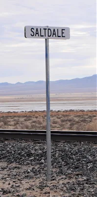
I found myself at the ghost town of Saltdale, twelve miles northeast of California City, along the Redrock Randsburg Road, and ghostly it was.

Saltdale rail siding

There is nothing left but a few housing slabs, blocks of cement, abandoned railroad tracks stretching across and into Koehn Lake, and the feeling that this place once was inhabited by family and friends.

Remnants of a house

I enjoy traveling. But sometimes, when exploring communities that no longer exist, there are questions about the place that come to mind along with the understanding there will be no satisfactory answers coming.

What happened to the people? Where did they go? Did they give-up on their dreams of success and just move away? Did they find happiness again, eventually?

Perhaps it was being mired in the endorheic lake for a few moments, which allowed my mind to wander rather pointedly toward the population that once resided beside this large empty lake.

Koehn Lake is also referred to as a sink lake or terminal lake. Simply put, it is a body of water with nowhere for the water to exit. There are no streams or rivers that run from it or to it. Thus, the water evaporates, often leaving behind large deposits of saline. Which in the case of Koehn Lake, was a money-making opportunity for those wishing an almost endless supply of salt within the Fremont Valley.

Dry Koehn Lake

The Mohave Desert has lots of ghost towns, and Saltdale happens to one of many – but it wasn’t always so.

In 1914, mining of the salt located in Koehn Lake, named after Charles Koehn, began by the Consolidated Salt Company. 

It turns out, there is a very interesting tale of claim jumping, gun play, and general shenanigans when it came to all the mining that was to go around this lake of salt at the time and the following decades to come. The whole drama is better suited for a Netflix series, then here in this column, since it gets rather complicated on who did this and who did that. I’d be tired by the time it was all written in chronological order.

Like being stuck in mud, being tired is not fun.

In 1913, the Consolidated Salt Company was formed, and in 1914 a crushing and screening plant was built, along with a small-gauge railroad track out into the dry lakebed. The mining results were amazing, with nearly two hundred and fifty tons of salt shipped out weekly by railroad cars. By the end of 1914, the total production was over twenty-thousand tons of processed salt.

Salt was very popular it seems, and still is.

“Do you want salt on your French fries,” a waitress may ask.

“And who doesn’t?” would be the response from an imaginary customer.

The production ran so high, that by 1915, the company was producing seven hundred and twenty tons a week and employed sixty-five workers to keep up with demand.

A post office opened in September of 1916 and the town of Saltdale was on its way to becoming mining boomtown.

But the Southern Pacific railroad could not supply enough cars to carry the salt. And that, is where the troubles first started. Because of the lack of cars, there was a delay in shipments up to five months. 

This is what modern economists would refer to as a supply chain issue, and no one wanted to wait five months to salt their fries.

Then, like in many melodramas, ‘fake’ claims were discovered and filed in court over the right to mine salt. 

Research showed more than a billion claims were filed over a few years and the production of the salt in the lake was divvied up between competing companies.

Between all the salt companies around the lake, over seventeen thousand tons of salt was processed in 1919.

In the same year, electric power was supplied to the mills and town by the Southern Sierras Power Company. The modern era had arrived.

More and more folks moved into the area and in 1920, the Saltdale School District was formed but very few students were enrolled. The students who did go to school, attended classes in the company’s office buildings in the beginning.  

So, no official schoolhouse was built at the time. 

“No, schoolhouse rocks for you!” the Superintendent may have yelled.

Production continued for years, but sometimes the rains did not, and the lake could no longer fill and evaporate leaving the salt deposits behind. The various salt companies would pump water into specific locations in Koehn Lake to induce the evaporation of the water but that was expensive and time consuming.

By 1924, only six men still worked at the Consolidated Salt Company.

And like many future ghost towns, Saltdale had its up and downs. Good wet seasons producing a bountiful of salt, and leaner drier years where production was minimal.

In the mid-twenties, a post office, gas station, grocery store, and a school were constructed along the Cantil-Randsburg Road.

There were local dances, picnics, dinners, and the more festivities making this a very friendly and safe community to reside in.

During the Great Depression, the town hung on but in the 1940s, gypsum was found in increasing amounts in the salt fields. This reduced the amount of pure salt being able to be processed and shipped out, thus continuing to reduce the number of workers at the various mills around the lake.

With the gypsum influx, and a few years of very low precipitation, Saltdale was on its way of becoming a ghost town. 

The post office closed in June 1950 and the school district formally dissolved the following year.

One mill owned by the Long Beach Salt Company, was able to keep operations going through these tough times, but none of the four workers lived in Saltdale. In 1975, the United States Interior Board of Land Appeals decided all mining claims on Koehn Lake were null and void.

It was the final death knell for a town named Saltdale.

Standing beside the abandoned railroad tracks reaching out into Koehn Lake, made me imagine what it must have been like to work and live in this remote area of the Mojave Desert. Sure, a small town with family and friends, but the nearest hospital or emergency services were in Randsburg sixteen miles away over a rough dirt road.

Tracks to nowhere

There is not much left to show where the school, post office, or other buildings were in Saltdale. The weather and the corrosive powers of the salt fields soon dispatched any remnants of the town. There is a section of railroad, near where a large modern platform had been built by the Southern Pacific Railroad in the 1930s.

Not wanting to venture any further across the wet surface of the lake, I decided the usage binoculars and a drone were the only safe ways to get a deeper look into the surroundings. I did not want to take another chance of losing my boots or worse to the brine awaiting me if I left the comfort of a solid footing.

Perhaps another season would encase the ground into a hard packed surface, but since it had rained recently – these were the best possibilities to learn more of what happened to this once thriving community.

A rusting tin roof of a building two hundred yards offshore peaked out from the salt surrounding it. It was as though the structure itself had died and was slowly crumbling out of sight. 

A sinking structure in the distance

A wooden set of railroad ties, being eaten away by the environment crisscrossed along the lakebed. The rails long gone, but the proof of a busy time from the past was evident.

Clouds covered the skies and a new chance for rain looked imminent. It was time to call this adventure done.

As I made my way back over the dirt roads to the pavement, my thoughts once again ran back to when this town was alive and vibrant.

Perhaps that is why I visit such places. To remember.


Wednesday, March 17, 2021

Cadiz - it is there

Welcome to Cadiz
I often find myself on the road, which is a good thing, since I write a travel feature each week for the Daily Press.  But sometimes I have no idea where to go, or where I might end up. And, that is sometimes, the beauty of traveling.

Go west young man, Horace Greeley told Mark Twain, and though I ain’t that young anymore, I just head out in any direction to see what there is to see. And there’s a lot to see.

Recently, while driving Route 66 – yes, I like America’s road – I came across a road closure sign just a few miles east of Amboy. I don’t like road closures. It seems there’s a reason why that road is closed and I want to know why. Is it closed due to a government secret? Perhaps an alien ship crashed in the desert that the government is hiding it from the citizens.

Think that’s far-fetched? Think Roswell, New Mexico, my friends.

So, anyway, I came across that road closure sign but when I read the fine print – it clearly said the road was closed to through traffic east of Cadiz Road. Well, that made all the difference in the world to me. Perhaps, I didn’t want to be a through trafficker past this Cadiz Road. That meant I could drive down the road to Cadiz and turn around, if I wanted to.

We think it means you can't drive any further
What was a Cadiz anyway? Wasn’t sure but knew I had to go there. Turned out the true closed road was exactly at Cadiz Road. That’s where the government actually was stopping any traffic from traveling further east on Route 66.
Route 66 - the Mother Road
What were they hiding? After a bit of research, it turned out there were no alien crash sites but simply the road was closed due to multiple bridges being washed out after some pretty heavy desert flooding in 2014. This section of highway has been closed for many years – many, many years. How long does it take to rebuild a few bridges? Apparently six, and counting…

Hmmm, I don’t believe in conspiracy theories, but I do believe in the occasional conspiracy. Maybe, just maybe, the Mojave Desert has a new Area 51.

I’ll check that out soon – I’m a professional explorer, so don’t try that on your own.

Back to Cadiz.

Turns out I had been to Cadiz. I had just forgotten momentarily, since it had been a bit over twenty years ago.

It happens to be one of the oldest constantly inhabited cities in Western Europe. This city, located on a piece of land jutting out into the Mediterranean Sea in Spain, is thought to have been founded in 1104 B.C. – oops, wait a moment. Wrong Cadiz.

Wrong Cadiz - nice looking though
Our Cadiz, the California one, was founded in 1883, by Lewis Kingman. He worked as a railroad engineer for the Atlantic and Pacific Railroad. This was the third railroad station located along this stretch of the Mojave Desert. Each station was alphabetical to its neighbor – Amboy, Bagdad, Cadiz, and so on. 

Driving into the area, the ruins of the Road Runners Retreat lines the south side of Route 66. This retreat was actually in what is now the ghost town of Chambliss – originally known as Chambliss Station. A water tower location for the railroads.

The buildings are boarded up. There’s no sign of life except for lizards, snakes, and possibly extraterrestrial life forms. I believe I saw a shadow run between two of the buildings. Can’t be certain, but the hair on my neck stood up. 

Not much left of Chambliss - a shame
However, this resort had plenty of life in the 1960’s, when Roy and Helen Tull built the comfortable and welcome resort for travelers along Route 66. But when Highway 40 was built miles away to the north, the business lost its customers and closed its doors in the mid 1970’s. The café struggled until the early 1990’s.

Once a bustling stop for travelers on Route 66
Chambliss, as with the resort, faded to obscurity with that darn highway that made traveling so much faster, but also so mundane. In fact, records indicate that in 2005, the population of Chambliss was six residents and a dog. I didn’t see a dog on my visit.

The sign for the resort is still standing tall. One can imagine the neon lights flickering in the clear night, beckoning road weary travelers for a bit of a respite from the dry desert.

Of course, there is the Bolo Station Bar/Grill and RV Park. It looked like life was percolating there. Well-kept buildings, tall trees, bushy bushes and plenty of space for RVs.  I drove in, asked a gentleman if I was in Cadiz, he pointed down the road and said three more miles.

Well, those three miles turned out to be quite interesting. As I thought I had been given erroneous information, suddenly there was the sign for Cadiz. There was no town. But, I did run across a smashed up vehicle on the east side of the asphalt. It looked like something out of Mad Max. Really cool.

This car has met Mad Max, and lost
Soon the asphalt ended and I was on dirt. I followed that dirt road to what appeared to be a large agricultural center. It should be noted that Cadiz actually sits atop one of the largest aquifers in Southern California. So much so, that it is listed as being able to supply water to Southern California for 400,000 residents with plenty to spare. The area is known for being in the forefront of water conservation and is earnestly working with the State of California, as well as the federal government for this very purpose.

As I drove into what was the labelled Cadiz Farm, I noticed what appeared to be a Christmas tree forest. But no, as I got closer and closer, the realization hit me that it was a gazillion acres of marijuana. 

Nope, not Christmas trees
I got out and walked through the fields for about ten minutes, or perhaps a couple of hours, or a week. Wasn’t sure, but when I got back to my truck, Jimi Hendrix was standing there playing his Fender Stratocaster. We laughed, exchanged musical lyrics and far too soon, he faded away – but just before he was gone, he smiled as only Jimi could and stated, “Cadiz you later.”

Turns out the farm actually produces an array of other farm produce – it’s a huge agricultural business.

Is Cadiz worth visiting? I enjoyed my time there, but with all traveling, there are hits and misses. I’ll take the hit on this, and perhaps you can take the miss. But then again - - -


Wednesday, January 13, 2021


I read that Kelso was a ghost town. I like ghost towns — though I have never met a ghost and, as I’ve mentioned before, the jury is still out for me as it relates to their purported existence.

Be that as it may, traveling the byways as I do, the prospect of stumbling across a real ghost town always thrills me — especially one from the late-1900s that may or may not let me see a ghost cowboy riding a ghost horse through the dusty streets of that ghost town.

"Howdy, partner. You ’fraida ghosts?”

I’d shake my head: “The jury is still out as it relates to your purported existence.”

“A jury found me guilty. Hung me and my horse.”

I saw that in a Mel Brooks film. Awkward moment. “Yeah, I bet they did. Can I take your photograph?”

“We’re what they call camera shy,” he would respond before riding off into the sunset. Not sure he’d ride exactly at sunset, but it sounds so cowboyish.

So, anyway, if Kelso — located about 35 miles southeast of Baker just off Kelbaker Road — is a ghost town, I knew there should be nothing there.

According to the Kelso entry on Atlas Obscura (what a truly cool name), “NOW LITTLE MORE THAN A ghost village, Kelso Depot is a historical oasis in the desert of the Mojave National Preserve.”


Not sure why Atlas Obscura went with all capital letters to open that statement, but it’s the reason I went to Kelso. Capital letters at the start of a description of a place must mean it’s worth visiting.

Would anyone travel to Italy to visit the Coliseum if the travel brochure read, “well, yeah, Rome is cool, if you like history and that kind of stuff”? I rest my case.

The history of Kelso is worth learning before your visit. The town was built in 1905 as a train depot. Soon after, people started arriving in droves.

Not being sure what a “drove” is, I did some research. One source stated that a person is drove when they are confused or mad, or if they just did something really stupid.

Another said a drove is when a number of animals, together, move to some place.

The latter is likely more accurate in this instance.

The bottom line is that people started moving to Kelso Depot, as it was known then, in large numbers. By the 1940s, over 2,000 called the town home.

Of course, it didn’t hurt that when those droves of humans moved in, borax and iron strikes were found locally, employing miners from everywhere. Then came the discovery of silver and gold in the nearby hills, and more droves of humans moved in.

“Follow the money” is an old saying, and the droves did just that. OK, I’m done with droves.

The mining area around Kelso was so successful that it actually became known as the Kelso mining district. An interesting point: The original name of the train stop was Siding 16 because of its location. It indicated that water was not far away.

Apparently Siding 16 sounded boring, so it was decided that a name needed to be chosen to give the place a true identity. Well, these were railway men, and they believed in doing things the engineering way. So, three names of local railroad workers were tossed into a hat and a name was drawn. The winner was John H. Kelso.

Rumor has it that John H. Kelso actually tossed in two dozen other slips of paper with his name on them, thus rigging the selection.

OK, I might have made that up. John H. Kelso was considered an upstanding community member. Check out that first name: Of course he was.

Kelso was the base of operations for the San Pedro, Los Angeles and Salt Lake Railroad, which connected with the Union Pacific Railroad tracks. It was also a great deal for the Atchison, Topeka and Santa Fe Railway. The depot furnished water and provided helper locomotives that assisted the longer trains heading up the steep grade toward Cima Hill.

Train coming into Kelso Depot

The train trip from Los Angeles to Las Vegas was long. Naturally, passengers and railroad workers needed a respite during their travels. Kelso Depot, then served as the perfect fit.

In 1923, the actual depot building was built. It offered a restaurant, boarding rooms and a telegraph office. The restaurant was named the Beanery, which served supposedly home-cooked meals.

I say supposedly because I’m not sure which family’s home laid claim to that fame.

“Yep, my house smells like a beanery. Want to come over for dinner? It’s a gas!”

So as the town grew, the depot became the center of the community. Meeting rooms in the basement allowed townsfolk to hold townsfolky events year round.

The building was beautifully designed, in the likeness of a California mission. It was the centerpiece for the small but vibrant desert village.

Kelso grew so rapidly that an old-fashioned, strap-iron jail was brought in. It was used for detaining local drunks and those not adhering to mask-wearing guidelines.

John, happy to be leaving the strap iron jail of Kelso

As always along these routes, the population dwindled with the advent of the automobile and super highways inconveniently (for Kelso) constructed miles away.

By 1986, the no-longer-needed depot was abandoned. By the mid-1990s, the railroad opted to tear it down.

The depot wasn't the only thing left behind - post office too

So when I drove into what I believed to be a deserted and nothing-to-write about town, I was pleasantly surprised: Kelso is not a ghost town.

It’s not a happening place, don’t get me wrong. But it’s not a ghost town.

People were walking around houses and a very not-torn-down Kelso railroad depot. In fact, the depot looks much like it did when first built back in 1923. It is gorgeous — and I don’t use that term lightly.

In the early 2000s, a group of historians decided that the depot needed to be saved. By 2005, the renovation was complete. A great job by all involved in this effort, I must say.

Green grass, tall cooling palms and lush green bushes line the walkways and yards to the entrance of the Kelso Depot Visitors Center, housed in the depot. I couldn’t wait to walk inside, meander the aisles of touristy stuff and ask some questions of the docents.

Nice enough for a long nap or yummy picnic

But 2020 means visiting in the time of the coronavirus, which means the place was closed.

I looked inside the windows to no avail. It was devoid of humanity.

I snapped a few photographs of the surrounding area. Watching at least a dozen or more tourists arrive in the center’s parking lot saddened me a bit. Motorhomes, trucks loaded with camping gear, cars with roof racks stacked with suitcases — all with seemingly nowhere to go.

But that is not accurate.

The great outdoors always beckons. Near the town of Kelso are ample opportunities to enjoy nature.

The Mojave National Preserve, where Kelso is located, is over 1.5 million acres of desert. That is enough area for anyone to enjoy hiking, off-roading, exploring, or just sitting at a campsite and the stillness of a desert evening.

Also nearby: the Kelso Dunes (which I planned to visit but ran out of time on this trip), Cima Dome (which I also planned to visit but ran out of time on this trip), and other locales which... you get the idea. Expect a sequel to this blog.


There are only so many hours in a day, but there are other days for a return to those places we missed at first. Kelso is not so far away in space or time that one cannot return and see more deeply what one missed at first glance. Every great adventure is worth a second glance.