Pages

Wednesday, February 17, 2021

Blythe Intaglios


 On a recent adventure, I stopped at a gas station and started filling the tank. A gentleman at a nearby pump smiled over at me.

Actually, I believe he was smiling, since the corner of his eyes crinkled. With nearly a year of wearing masks outside, it’s now easier than ever to know a person’s expression. 

Eyes crinkle – there’s a smile. I crinkled back while nodding my head.

“Do you enjoy Italian ice cream?” he asked, from beneath his green plaid face covering.

Not sure how to react, I just nodded, and crinkled my own eyes.

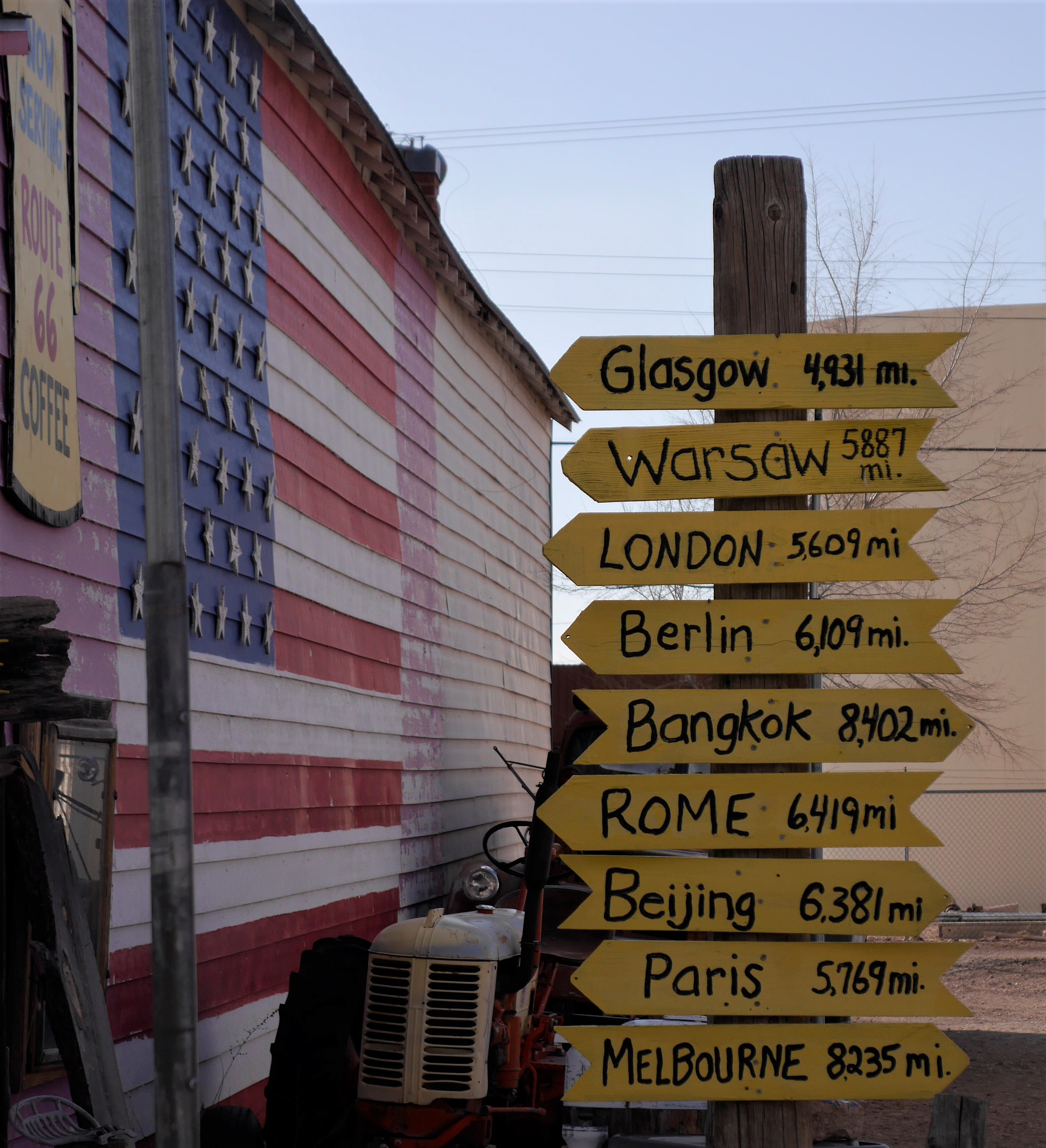
He pulled the bottom of his mask out a bit. “Sorry, stupid mask. I asked if you have had a chance to enjoy the Blythe Intaglios. Since you’re in Blythe and all.”

The truck filled, I shook my head. “Nope, I gotta go,” I mumbled through my own mask, a sharp looking black one, with Route 66 stenciled on it. I had no idea what he was talking about, and for once, I wasn’t curious. 

“What were you discussing with that guy by the pump?” Laureen asked. She’s always curious.

“I don’t know. Something about an Italian dessert, I think.”

“What?”

“Yeah, weird,” I responded. “Something to the effect, if I enjoyed Blythe Intaglios. I didn’t even know Blythe had an Italian restaurant, let alone one serving ice cream.”

Silence for a moment, and then Laureen stated. “He was possibly talking about geoglyphs. Like the Nazca Lines in Peru.”

I started the truck. “Please, ask Mr. Google that, and let’s see if it’s ground art or Italian ice cream.”

Turns out, that the Blythe Intaglios are actually a group of figures etched into the desert floor. I mean, some pretty large figures of humans, animals, and swirling markings on the ground.

Intaglios is not a dessert - but this looks yummy

Never knew they were there. In fact, there are over two hundred of these geoglyphs in the Colorado Desert.

Okay, what is a geoglyph? 

According to the website, geographyrealm.com, a geoglyph is ‘a work of art which is created by arranging or moving objects within a landscape.’

I move stuff in my yard a lot, so I must have created geoglyphs without even knowing about it. Laureen should be proud.

“Honey, I moved that pile of leaves, leaving some pretty interesting rake marks.”

“You are nothing but a brilliant artist, creating a geoglyph such as that.”

The praise would never stop.

Actually, geographyrealm.com, wouldn’t agree with my depiction of the art work created by moving a bag of leaves from my yard.

‘For an art form to be regarded as a geoglyph it must generally be more than 4 meters in length. It must also be stated at this point that this art form is difficult to see or even be identified on the ground but are easily appreciated when seen from the sky.’

Then what is this Italian ice cream, the guy at the gas station was talking about? Oh, sorry, the Intaglios.

Sounds rather snooty to me.

Where would I find the definition for such a word? Of course, I used the website, myintaglios.com – where else would anyone think to look?

Intaglios, is an Italian word that means engrave. According to the experts, they must be with such a website, the term is even deeper.

‘An intaglio is an object that has had some shape of figure engraved or incised into its surface.’

Why couldn’t the Blythe thingies be referred to as the Blythe Geoglyphs? Why make the carvings on the ground sound like a dessert?

“Do you have room for a nice Italian Intaglio?”

“Ah, no, I am stuffed with the two helpings of Cacio e pepe. Thanks, though.”

Anyone, who has traveled to the boating meccas along the Colorado River, probably have passed the location many times. Yep, heading north along U.S. Highway 95 from Interstate 10, out of Blythe – you can't miss the place.

Pulling the boats, the jet skis, the trailers, the desert toys along that ribbon of black asphalt, you’ve passed the place. 

Going to Parker – you’ve passed the place.

You get my point – you’ve passed the place.

But did you stop?

A stop is needed to view this intriguing historical site. It’s an easy, well-marked dirt road and the stop is worth it - even pulling boats or toys,

According to the Bureau of Land Management, the drawings in the Blythe area, were created by the natives living there about 450 to 2,000 years ago. But, other research indicated the drawings are only between 900 to 1200 years old.

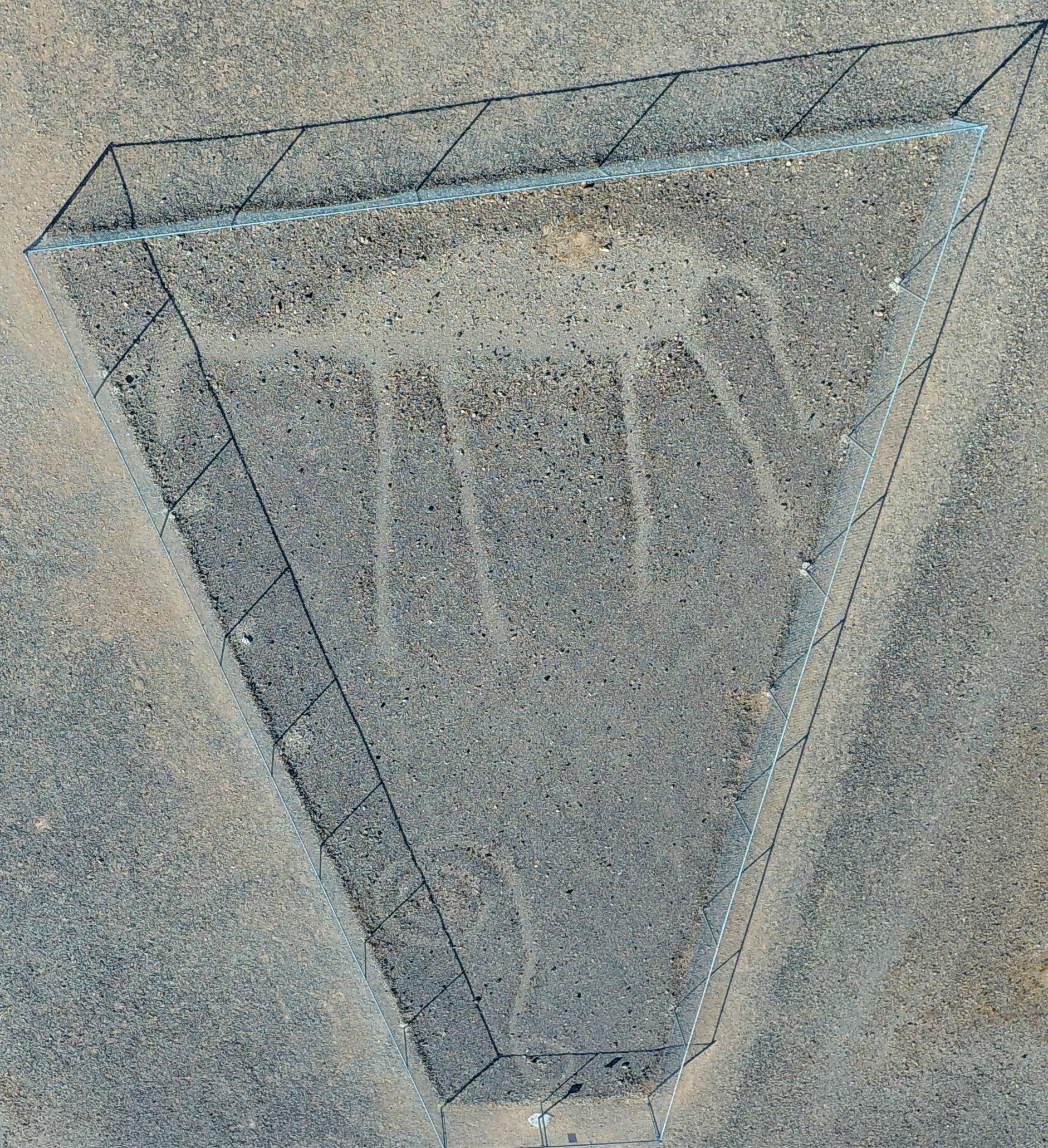
Drone shot - shows the entire drawing

Since there is no written record from that time period, it is only best guess work when these involved pieces of ground art work were actually scraped.

So, again, what exactly is a geoglyph? Think of the Nazca Lines in Southern Peru – those most folks are familiar with. They scraped out desert drawings of birds, people, animals, and other objects were made about 1500 to 2000 years ago. These drawings are huge, one measuring well over 1,200 feet long.

Giant spider in Nazca, Peru 

Laureen and I almost saw these drawings, when we visited Peru with our children years ago. We were headed to Cuzco, to visit Machu Picchu, with a planned stop at Nazca to take in the ancient land carvings.

Of course, we took the supposed twenty-one hour bus trip from Lima to Cuzco aboard First Class Bus Service.  Nothing is too good for my family.

Took us nearly thirty-two hours. A muffler flew off two hours out of Lima, leaving our ears ringing for weeks, as if we had been working with jack hammers every day. When we reached Nazca at two in the morning, the bus suddenly needed a fuel pump.

The driver was very apologetic though. “I am so sorry, we won’t be able to see the lines in the ground. It’s too dark and we are way behind schedule.”

“What?” I asked, his mouth was moving, but all I could hear were bass drums pounding in my ears.

Not quite this bad - but pretty bad

The flight from Lima to Cuzco is only a bit over an hour. Note to self, don’t be so cheap in my next life.

In the Blythe Intaglios area, there are six figures in three locations. There are three human figures – though Laureen swears one of them is an alien, two four footed animals, and a spiral – could be a snake or some other slithering reptile – I’m not sure. But what I am positive of is, that they are all worth taking a look at.

Desert animal and squiggly lined thing

It is believed, per the BLM and others that they were created either by the Mohave or Quechan tribes, but as far as my research showed, no Native American tribe has taken credit for the drawings.

An interesting point is, that most of the 200 such geoglyphs located in the desert are near the Colorado River. Makes sense, since many of the tribes believe that this mighty river was the sustainer of life for the desert dwellers. Water means life, so, perhaps in respect, these giant ground drawings represent gratitude for having the life sustaining river so close by. 

We may never know why they were drawn or by whom, and according to geographyrealm.com,

‘As of today, we can say only one thing – the geoglyphs were built by ancient people. By whom and for what purpose, remains a mystery.’

Since the Blythe Intaglios are so huge, for example, there is one depicting a male is 171 feet long, it is best to view them from the air.

The big guy - scientific for - The big guy

I tried hoisting Laureen onto my shoulders so she could get a better look, but that ended in a complete disaster.

Hard to see from ground level - but see, you can

So, the use of a helicopter or drone is the best way to view these marvelous art works. I settled on a drone.

Of course, the figures can easily be seen by looking at them from ground level, and that is what counts. To look, and appreciate the ingenuity of a culture who carved a belief into the ground, possibly without realizing people hundreds or thousands of years later would also appreciate their single dedication with such artwork.

We certainly did.


Saturday, January 30, 2021

Seligman - the place to go


John enjoying Seligman on Route 66

According to Eric, an employee at The Rusty Bolt (his mother, Linda owns the shop), COVID-19 has wreaked havoc on the small but usually vibrant town of Seligman, Arizona.

“Most of our tourists are from out of this country,” Eric stated. “I’d say seventy to seventy-five percent, actually.”

For this iconic place along Route 66 between Kingman and Flagstaff, that is a lot of shoppers to lose from a pandemic – actually, a loss like that could be fatal for any business.

The small store sells Route 66 memorabilia, leather goods and beautiful handmade jewelry.  

“Most of our customers come from France. They love hanging out in town and taking in the Old West flavor.”


Seligman, has old west written all over it
Be careful though, you could wind up in the pokey like Laureen

I’ve heard this from many of the folks I met along Route 66 over the past couple of years. Most tourists, when tourists are actually being tourists, and traveling along Route 66, are Europeans. Mainly French and German, with a smattering of everyone else from across the pond.

The day Laureen and I were visiting showed a stark contrast from our earlier visits to this high desert plains town.

In fact, we spent a bit of time there when I was doing research for my first novel, Hunted – yes, that’s an unabashed plug for a great book. 

A truly grizzly scene occurs in Seligman

When we were there, the place was rocking with tourist buses, rental cars, and lots and lots of motorcycles. Restaurants like the Roadkill CafĂ© and OK Saloon were jammed packed with people who wanted to spend a moment experiencing the allure of the Old West and the glamour of the bygone era of Old Route 66 in its heyday. Most of the motels, all with that distinctive 1960’s appearance, had blinking lights stating there was no vacancies to be had.

It was a rollicking and rolling town.

This last visit though, looked more like a ghost town. A ghost town with all the shops and restaurants open, and few, if any vehicles in the parking lots.

It was sad. 

We bought a couple of items from the Rusty Bolt, bid ‘Au revoir’ and ‘Auf Wiedersehen’ to Eric, and went out to walk the empty streets of Seligman.

Shops are open 

In the beginning, the large valley was home to the Havasupai tribe, who resided where present day Seligman is located. Lots of flat land, sparse trees, but teeming with wildlife that made it a perfect place to live. In fact, on our way to Seligman along Interstate 40 – yes, we do take these faster routes sometimes -- we saw dozens of elk, deer and other critters running here and there. 

Soon settlers were making their way into the Chino Valley in northern Arizona along a well-worn trail which was called Beale’s Wagon Road.  It was named after the 19th century explorer, Edward Fitzgerald Beale, whose job it was to find a trade route from Fort Smith, Arkansas to Los Angeles.

After a few decades, the railroads started laying tracks across Beale’s Wagon Road and presently a junction was created with the Santa Fe mainline and the Prescott and Arizona Railway Company. The name of the junction soon became known as the Prescott Junction since it was the major turning point south to the town of Prescott. In 1886, the junction was renamed Seligman.

Why Seligman? There was no hanky-panky with people putting their names in a hat and drawing one out, nope – Jesse Seligman was the person who helped finance the railroad line. He was out of New York, and had formed a rather large investment bank named, J. & W. Seligman & Company.

“Mr. Moneybags, what should we name the area you are financing to build a railroad?”

“Let me think, hmmm, how about after me? Yes, Seligman sounds like a perfectly good name for a junction. I don’t care for the name Prescott Junction, and I hear Petticoat Junction isn’t available due to a future television show.”

“What’s a television?”

The flatness of the area, allowed ranchers to bring their cattle to the railroad for shipping, and the railroad built huge switching yards to accommodate more trains. After a while, the area became so popular, as a terminal point for changing train crews, that cottages and more permanent buildings began to rise up from the high plains.

Well, actually people built the buildings – they didn’t rise up on their own. Just wanted to point that out, in case there was any confusion.

“Look ma, that there saloon just popped up like a weed from the ground.”

“Sounds like you been visiting that saloon too much, young man.”

In 1905, Fred Harvey, the hotel and restaurant entrepreneur, opened the Havasu House – it was the same concept of all the other Harvey Houses, but this one was named in honor of the Havasupai peoples living in the area. 

People hanging out at the Harvey House - dcourier.com

With passenger trains stopping in Seligman on a regular basis, as well as all the other train freight that rolled along the tracks, Seligman became a very popular place to visit. 

The town boomed.

Soon that black ribbon, known as Route 66, raced across northern Arizona, and the town became a popular respite for road weary travelers. Gas stations, tire repair shops, restaurants, motels, and all the other businesses which were needed for a thriving community were built to welcome those weary travelers.

Laureen posing in front of a car that drove Route 66 in the day

But, as with all these stories dealing with Route 66, things changed.

Here we go again – a pioneer trail beckons a railroad stop, that turns into a booming town, and with the construction of Route 66 really becomes a place to expand, and then Interstate 40 comes along. Whammo, the town dries up and blows away in the wind.

Not so for Seligman.

In 1978, when Interstate 40 opened, the citizens of Seligman felt the stranglehold of a faster route through Northern Arizona, and realized that time was of the essence if this historical town were to continue to exist.  

This town had the true western fighting spirit. 

It is reported, that when this pugilist attitude was reported internationally, the famous British secret agent, Austin Powers, was heard to exclaim, “Yeah, baby!”

Austin felt very groovy about Seligman fighting the government

The local residents stood together, and convinced the State of Arizona to dedicate their section of Route 66 a historic highway. 

According to azcentral.com, ‘In fact, Arizona touts the longest continuous stretch of uninterrupted two-lane asphalt grandeur: 158 miles stretching from just outside Ash Fork in the east to the Colorado River in the west.’

And Seligman sits pretty much in the middle of that stretch of Route 66. 

The plan and effort of the people worked and the businesses survived. Just being a short distance north of Interstate 40, people would visit the historical town in great numbers, all year long.

Seligman is a place to experience. It is kooky, eclectic, and strange - store fronts, as well as porches and roofs sport mannequins, antique vehicles are parked everywhere, the famous Black Cat Bar has been around since the early 1900’s and is still going strong. 

Just some of the eateries open


Almost close to everywhere


It is truly a place one can enjoy spending some time in.


Unique shops awaiting customers


Laureen enjoying a ride through town

Unfortunately, the Havasu House only made it to 1954 when it closed for good. It was demolished in 2008.

Such a waste of a historical place.

But, (and isn’t there always a but in these sort of stories), the town is open and inviting all visitors to come and experience the history of not only an old western destination, but one that proclaims the future is still looking pretty good for Seligman.

Of course, all serious precautions are taken for this cursed pandemic of COVID-19 through the town, but with that caution, a traveler will still have a great time learning about a part of Americana that still exists in the Southwest.

What else would be expected while traveling the ‘Mother Road’ of America?

Don't be left out - get your drive on


Wednesday, January 13, 2021


I read that Kelso was a ghost town. I like ghost towns — though I have never met a ghost and, as I’ve mentioned before, the jury is still out for me as it relates to their purported existence.

Be that as it may, traveling the byways as I do, the prospect of stumbling across a real ghost town always thrills me — especially one from the late-1900s that may or may not let me see a ghost cowboy riding a ghost horse through the dusty streets of that ghost town.

"Howdy, partner. You ’fraida ghosts?”

I’d shake my head: “The jury is still out as it relates to your purported existence.”

“A jury found me guilty. Hung me and my horse.”

I saw that in a Mel Brooks film. Awkward moment. “Yeah, I bet they did. Can I take your photograph?”

“We’re what they call camera shy,” he would respond before riding off into the sunset. Not sure he’d ride exactly at sunset, but it sounds so cowboyish.

So, anyway, if Kelso — located about 35 miles southeast of Baker just off Kelbaker Road — is a ghost town, I knew there should be nothing there.

According to the Kelso entry on Atlas Obscura (what a truly cool name), “NOW LITTLE MORE THAN A ghost village, Kelso Depot is a historical oasis in the desert of the Mojave National Preserve.”


Not sure why Atlas Obscura went with all capital letters to open that statement, but it’s the reason I went to Kelso. Capital letters at the start of a description of a place must mean it’s worth visiting.

Would anyone travel to Italy to visit the Coliseum if the travel brochure read, “well, yeah, Rome is cool, if you like history and that kind of stuff”? I rest my case.

The history of Kelso is worth learning before your visit. The town was built in 1905 as a train depot. Soon after, people started arriving in droves.

Not being sure what a “drove” is, I did some research. One source stated that a person is drove when they are confused or mad, or if they just did something really stupid.

Another said a drove is when a number of animals, together, move to some place.

The latter is likely more accurate in this instance.

The bottom line is that people started moving to Kelso Depot, as it was known then, in large numbers. By the 1940s, over 2,000 called the town home.

Of course, it didn’t hurt that when those droves of humans moved in, borax and iron strikes were found locally, employing miners from everywhere. Then came the discovery of silver and gold in the nearby hills, and more droves of humans moved in.

“Follow the money” is an old saying, and the droves did just that. OK, I’m done with droves.

The mining area around Kelso was so successful that it actually became known as the Kelso mining district. An interesting point: The original name of the train stop was Siding 16 because of its location. It indicated that water was not far away.

Apparently Siding 16 sounded boring, so it was decided that a name needed to be chosen to give the place a true identity. Well, these were railway men, and they believed in doing things the engineering way. So, three names of local railroad workers were tossed into a hat and a name was drawn. The winner was John H. Kelso.

Rumor has it that John H. Kelso actually tossed in two dozen other slips of paper with his name on them, thus rigging the selection.

OK, I might have made that up. John H. Kelso was considered an upstanding community member. Check out that first name: Of course he was.

Kelso was the base of operations for the San Pedro, Los Angeles and Salt Lake Railroad, which connected with the Union Pacific Railroad tracks. It was also a great deal for the Atchison, Topeka and Santa Fe Railway. The depot furnished water and provided helper locomotives that assisted the longer trains heading up the steep grade toward Cima Hill.

Train coming into Kelso Depot

The train trip from Los Angeles to Las Vegas was long. Naturally, passengers and railroad workers needed a respite during their travels. Kelso Depot, then served as the perfect fit.

In 1923, the actual depot building was built. It offered a restaurant, boarding rooms and a telegraph office. The restaurant was named the Beanery, which served supposedly home-cooked meals.

I say supposedly because I’m not sure which family’s home laid claim to that fame.

“Yep, my house smells like a beanery. Want to come over for dinner? It’s a gas!”

So as the town grew, the depot became the center of the community. Meeting rooms in the basement allowed townsfolk to hold townsfolky events year round.

The building was beautifully designed, in the likeness of a California mission. It was the centerpiece for the small but vibrant desert village.

Kelso grew so rapidly that an old-fashioned, strap-iron jail was brought in. It was used for detaining local drunks and those not adhering to mask-wearing guidelines.

John, happy to be leaving the strap iron jail of Kelso

As always along these routes, the population dwindled with the advent of the automobile and super highways inconveniently (for Kelso) constructed miles away.

By 1986, the no-longer-needed depot was abandoned. By the mid-1990s, the railroad opted to tear it down.

The depot wasn't the only thing left behind - post office too

So when I drove into what I believed to be a deserted and nothing-to-write about town, I was pleasantly surprised: Kelso is not a ghost town.

It’s not a happening place, don’t get me wrong. But it’s not a ghost town.

People were walking around houses and a very not-torn-down Kelso railroad depot. In fact, the depot looks much like it did when first built back in 1923. It is gorgeous — and I don’t use that term lightly.

In the early 2000s, a group of historians decided that the depot needed to be saved. By 2005, the renovation was complete. A great job by all involved in this effort, I must say.

Green grass, tall cooling palms and lush green bushes line the walkways and yards to the entrance of the Kelso Depot Visitors Center, housed in the depot. I couldn’t wait to walk inside, meander the aisles of touristy stuff and ask some questions of the docents.

Nice enough for a long nap or yummy picnic

But 2020 means visiting in the time of the coronavirus, which means the place was closed.

I looked inside the windows to no avail. It was devoid of humanity.

I snapped a few photographs of the surrounding area. Watching at least a dozen or more tourists arrive in the center’s parking lot saddened me a bit. Motorhomes, trucks loaded with camping gear, cars with roof racks stacked with suitcases — all with seemingly nowhere to go.

But that is not accurate.

The great outdoors always beckons. Near the town of Kelso are ample opportunities to enjoy nature.

The Mojave National Preserve, where Kelso is located, is over 1.5 million acres of desert. That is enough area for anyone to enjoy hiking, off-roading, exploring, or just sitting at a campsite and the stillness of a desert evening.

Also nearby: the Kelso Dunes (which I planned to visit but ran out of time on this trip), Cima Dome (which I also planned to visit but ran out of time on this trip), and other locales which... you get the idea. Expect a sequel to this blog.


There are only so many hours in a day, but there are other days for a return to those places we missed at first. Kelso is not so far away in space or time that one cannot return and see more deeply what one missed at first glance. Every great adventure is worth a second glance.