Pages

Tuesday, February 25, 2025

Tragedy at Charlestown Peak, Nevada

Looking toward the peak of Mount Charlestown, Nevada

“There was suddenly a clear space in the skies above Mount Charleston and the pilot took advantage of it,” Docent Arlene said. “He pulled back on the controls believing he could make it over the summit despite the terrible winter weather.”

Laureen, my lovely wife, and I were visiting the Spring Mountains Visitor Gateway near Mount Charleston a mere 40 miles northwest of Las Vegas.

The wind was blowing from the west down through the snow-covered valley of the Spring Mountains, leaving both Laureen and me wishing we had brought warmer clothes for this afternoon's venture. Hiking boots, shorts, and thin sweatshirts were no match for the sometimes 50-mile-an-hour gusts howling down upon us with a touch of freezing.

The three of us, Docent Arlene, Laureen and I were gazing at a large bent and misshapen airplane propeller on display outside of the Visitor Center.

That wintery day back on November 17, 1955, proved a bit too tricky for the pilot navigating the C-54 Cargo plane, registered as USAF 9068.

How Mount Charlestown may have appeared at time of crash

“I’ve heard that if he had gained less than fifty feet or so the plane would have made it over the peak and headed toward Las Vegas, their final destination,” Docent Arlene stated. “Unfortunately, that peak in the distance was their final destination, killing all fourteen men aboard.”

Memorial for those lost on Mount Charlestown, Nevada

It was two o’clock in the afternoon and we had just finished a yummy lunch at The Retreat on Charleston Peak a bit earlier - we shared a large burger with a patty made of a mixture of bison, Wagyu beef, elk, and wild boar cooked to perfection. Washing it down with a nice cold Stella, made the meal that much more satisfying.

The Retreat near Charlestown Peak, Nevada

We had stopped by the Visitor Center to learn what we could about this mountain situated less than an hour's drive from Las Vegas and yet worlds away from that hustle and glitter.

There was no way that I could have imagined that we were going to learn about an aircraft that had slammed into Mount Charleston carrying 14 men heading from Burbank, California on its way to the top-secret installation of Area 51.

Yes, the very base in the Nevada Desert that houses intergalactic flying saucers, little skinny gray space aliens, and probably a few Sasquatches for good measure.

All the folks who perished during that winter storm atop Mount Charleston in 1955 on flight USAF 9068 were secretly working on the U-2 project. The plane that would change the way the United States routinely spied on their adversaries around the world, and perhaps allies too - just speculating.

In fact, according to Docent Arlene, the mission was so secret that the military never told the families of those aboard anything about how they died, let alone why their loved ones happened to be flying over Mount Charleston in the first place during a terrible winter storm. The plane was supposed to keep a maximum height of 10 thousand feet to maintain invisibility from radar but with the nasty weather, the pilot got a bit off course and suddenly realized too late that he had to try to make it over the nearly 12,000-foot peak of Mount Charleston.

As history records, George Pappos did his best but those last feet were just out of reach for the seasoned pilot trying to ferry his cargo of scientists to Watertown - codename for the desert area where things were being constructed and tested out of the view of the general public.

When traveling, as I do quite often, there are times when you learn about stories that come as a surprise. This was one of those times.

Not about the shenanigans going on in Area 51 - nothing surprising there. No, that top-secret base is probably one of the best-known top-secret places on this planet. 

I’ve been on the outskirts of Area 51 numerous times and once nearly was detained when a white SUV came barreling toward me on a remote dirt road. I hightailed it, and just caught in the rearview mirror the driver in the truck waving at me with a skinny hand with only three fingers attached. The passenger leaned out of the window yelling something, and I swore he had antennas stuck to his rather large-eyed head.

But, I digress.

We happened to be in Las Vegas to see the band ZZ Top at the Palms when we decided to drive the short forty minutes to Mount Charleston. In all transparency, we have visited the beautiful small town a few times in the past but nearly six years had glided by so we thought it would be a nice outing away from the glitter and hubbub of Sin City.

Little did we know that we would learn so much about the Cold War while talking with Docent Arlene at the Spring Mountains Visitor Gateway.

“For decades the families never truly knew what had happened to their loved ones,” Docent Arlene said. “The government wanted to keep the facts of the incident close to their chest, and they succeeded.”

Laureen and I wandered about the visitor center a bit and picked up a few more details pertaining to the crash. It was sad looking at photographs of what remained of the C-54 on top of Mount Charleston after the horrific crash.

A large debris field showed that the plane had nearly made the peak but instead bellied into the hard snowpack and skidded for dozens of yards before erupting into fire. It took time for responders to reach the peak with the weather and rescue equipment available in 1955, but it would have made no difference. Experts determined later that in all probability those aboard perished almost instantly upon impact. 

When the plane crashed and the military had removed the remains of the 14 men killed, the plane rested in its last landing position for years. The peak is treacherous and not easy to hike to, though people do during the summer and early fall when it is not covered by snow.

Through the decades, souvenir scavengers would scale Mount Charleston for mementos of the tragic airplane crash. It was becoming more and more hazardous, not to mention disrespectful, to allow tourists to venture into the damaged fuselage which was moving a bit more down the mountainside with each winter snowfall, so the US Forest Service had the fuselage blown up for safety reasons.

Some of the original propellers and plane debris still lay twisted and abandoned on the peak today. The engines were removed by the military and later reused in other aircraft.

One propeller is at the Spring Mountains Visitor Gateway and proudly on display at the National Cold War Memorial located on the grounds of the Gateway as a reminder of the once unknown heroes of the nearly 50 year Cold War against the then Soviet Union. 

One engine propeller from atop Mt. Charlestown 

It is the only National Memorial site in the state of Nevada.

We were told that the wind gusts were going to be hitting higher soon and the electricity was being turned off on Mount Charleston at four due to fire hazards in case of a downed power pole.

One more gander around the Cold War Memorial set in the beautiful setting of Spring Mountains and we were on our way back to Las Vegas and the concert.

But, in the parking lot, I stood a moment or two gazing at the snow-covered peak of Mount Charleston in the distance and wondered what it had been like for those 14 men knowing that was indeed their last flight.

I hoped they had not known it was.


For more information: https://www.gomtcharleston.com/

https://retreatoncharlestonpeak.com/


A good read on the topic: Silent Heroes of the Cold War by Kyril D. Plaskon


John can be contacted at: beyersbyways@gmail.com


Saturday, February 8, 2025

Seven Magic Mountains, Las Vegas

A virtual rock landscape of colors

My wonderful wife, Laureen, and I were visiting Las Vegas, when a guest at the Venetian asked me if we had stopped along Interstate 15 to check out the Seven Magic Mountains.

“They are a work of art,” the man dressed in puffy sleeves and tights told me. “We stop there every time we come to Las Vegas.”

Magic mushrooms I remembered. A great time to sit back and contemplate the events of the world while studying one’s navel. But magic mountains?

“Dude,” a long haired-hippie-dude may have said. “These shrooms are like opening up the universe to me, dude.”

If I had been there, I may have replied, “Dude, you look like a walrus but with a tighter mustache.”

Of course, the above is just for giggles. I have never delved into the world of drugs. Though there was a time when possibly I ingested something innocently and two days later round up at Machu Picchu in Peru, where a Shaman had tattooed a map of the lost Incan treasure on my hairy back. 

“It’s a map,” I confessed to Laureen.

“They are freckles,” she stated with a roll of the eyes that could be felt in Cuzco,

Sure, then why did I keep getting emails from the History Channel from lost treasure hunters?

So, on the way out of Sin City, we decided to pull off of Interstate 15 and investigate all the hubbub of these Seven Magic Mountains.

“Should have stopped by a CBD store for this experience,” I said to Laureen.

“Put the car in park.”

The free parking lot was full. I had to wait until a family decided they had had enough of the Seven Magic Mushrooms - oops, the Seven Magic Mountains -- before a spot was available,

The father looked at his wife, who was jockeying the horde of kids into the minivan, “I swear I saw Captain Kirk standing by one of the tall rock sculptures. He spoke to me.”

With the last child seatbelt fastened, the wife calmly took the vehicle's keys and instructed her husband there would be no intergalactic travel that day.

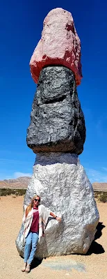
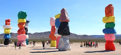
Running parallel with Interstate 15, approximately a dozen miles south of Las Vegas,this is a sight to behold. Huge multi-colored boulders stacked on top of each other towering over the flat desert landscape. 

It's not just the juxtaposition of these structures that makes a traveler ponder how this could be created but the gorgeously vivid colors painted on each boulder is an artistic palette.

There were so many folks wandering around the boulder works of art that I lost count.

There were Hindus, Taosists, Shintos, Christians, Islamists, and those with tin foil wrapped around their craniums.

Yes, being a travel writer I asked each person where they were from. I suddenly stopped when a man stated that he had just been released from San Quentin.

“The teardrop tats beneath my eyes,” he said, “Nothing to concern yourself with”

It was a place for all, and all were welcomed,

The creator of this field of creativity was a Swiss artist by the name of Ugo Rondinone. His dream was to explore, ‘a creative expression of human presence in the desert. Seven Magic Mountains punctuates the Mojave with a poetic burst of form and color.’

In the middle of nowhere, Ugo decided to stack boulders, some over 30 feet tall, to allow travelers enroute along Interstate 15 to share in his vision in the Nevada desert.

It should be noted that the work was funded and sponsored by the Nevada Museum of Art, along with other non-profit groups who were very excited to be part of the largest land based art installation in the United States in the last 40 years. 

I really had no idea what a land based art installation was until I asked Mr. Google. But, it is really a cool thing to experience up close and personal.


The process was not easy when the art project began in December of 2015. Huge boulders were brought to the location and then were carefully cut into smaller boulders to Rondinone’s exact specifications.

Once the large boulders were cut into the correct size according to the artist, holes were then cut through to allow each boulder to sit atop another by the use of metal rods and bolts to ensure they would not topple over on visitors.

Nothing worse than having a 40,000 pound neon pink boulder falling on a guy taking a selfie at the bottom of a column of boulders,

“Well, that little incident won’t be staying in Vegas,” a tourist may note after watching a six foot male squashed into the desert floor. 

The project took an entire army of engineers, metal workers, boulder cutters, crane operators and other construction experts to complete Rondinone’s dream.

The motto of how it was all put together was simple - ‘One boulder at a time.’ And with 33 boulders, one weighing nearly 56,000 pounds, that was a lot of combined effort and talent.

What stands out, besides the feeling a person may be looking at a modern day StoneHenge painted in various colors of day-glo paint, is the precarious-appearing boulders stacked on top of each other. They seem to be defying gravity for the onlooker.

Being situated near Jean Dry Lake, within the Ivanpah Valley, winds howl through the flatness of the desert like folks running through the front doors of Walmart on a Black Friday sale.

“Watch out Ethel,” a husband may say to his wife. “The winds are blowing nigh-on three hundred miles per hour. And don’t forget that they have big screens for a buck today.”

The amount of engineering genius it took to ensure those boulders don’t fall over in the extreme desert conditions is amazing. 
A true balancing act

With the backdrop of the Sheep Mountains, the Seven Magic Mountains is the perfect opportunity for both amateur and professional photographers to get out and about for that perfect frame.

Per the Seven Magic Mountains website, ‘the installation creates a dialogue between the natural and the artificial, the rural and the urban. The natural form of the rocks contrasts with their artificial paint, symbolizing the intersection of human culture with the natural world,’

That was cranium deep.

When asked, Rondinone stated, “I just had some time on my hands and a bunch of boulders in the front yard, and I thought - why not?”

Actually, he did not say that.

Situated on Bureau of Land Management land, the artist was allowed just two years to display the brightly painted seven stacked columns of boulder,s but after it was completed in 2016, the response was so positive that the BLM allowed another couple of years to pass, Now, after having nearly 1,000 visitors per day touring the land based art installation, that has been extended through 2027.

As Laureen and I wandered around the luminescent boulder creations, we suspected this timeline may be extended as well. It is free to park, free to enter, and free to experience the wonders of the desert suddenly alive with tall beautifully sculptured pieces of art.

John R Beyer, loving the shades of colors

I took a photo of Laureen near a vivid purple boulder. Laureen took a photo of me standing by a bright blue boulder. Laureen was asked to take photos from strangers as they posed with their families in front of various colored boulders.

Laureen Beyer, holding up a stack of brightly painted rocks

I offered, but with a smile the strangers declined and handed their phones and cameras to Laureen. I wasn’t upset by the slight, since I did not want to take their dumb photos in the first place.

With the hundreds of people walking about the exhibit, it was refreshing to see all the smiles, the wonder in voices, and the joy people felt by just being in the center of this magical art destination.

As I mentioned, every color, every nationality, every creed was on display with the folks visiting and enjoying one man’s vision to bring us all together at the Seven Magic Mountains.

Lots of visitors each and every day

We talked to each other, pointed this and that out to each other, and smiled goodbye when we left. It was an enriching experience and one that should perhaps be duplicated worldwide.

That would be nice.

For more information:  https://sevenmagicmountains.com

John can be contacted at beyersbyways@gmail.com


Sunday, January 26, 2025

Rainbow Basin, Barstow, CA

Though I have traveled down this narrow, winding dirt path multiple times in the past, it seemed as if it were the first time I’d taken the route.

That is the amazing mystery of adventuring here and there. You may have visited a certain park, lake, town, or some other destination multiple times in the past but suddenly the experience seems like a first.

I’m the usual suspect in the driver’s seat when motoring here or there. Mostly, because I travel alone on the byways the majority of the time. But on those occasions when company is present, they tend to sit in the passenger seat looking out the window trying to ignore my storytelling. 

“Stop me if you’ve heard this story,” I may say to Laureen, my lovely wife. “I was almost run over by a five thousand pound bull in Pamplona . . .”

“Stop.”

“Did I ever tell you the time a Sasquatch and I sat by the campfire in western Oregon, sharing a bottle of Macallan and a smooth Fuente y Padron?” I may ask Paul, a sometimes traveling friend.

“Stop.”

So, as I idled through the twisty twists of Rainbow Basin, my thoughts turned back to wondering if I had ever seen these natural geologic formations before.  I had, and yet somehow they appeared fresh and new, like a pair of white socks when washed in hot water and not cold. Laureen taught me that trick, and to this day, beige (used to be white) socks will never again caress my feet.

Rainbow Basin is passable by most vehicles 

Rainbow Basin lies just a few miles northwest of Barstow and is maintained by the Bureau of Land Management. It is easy to find right off Irwin Road with a large sign that points north telling the traveler the basin lies just another few miles away along a wide but oftentimes bumpy dirt road.

Any vehicle can cruise along the road but no large vehicles should attempt to enter the trail which leads through Rainbow Basin itself. Some of those humongous monstrosities from the Mad Max films may find the hairpin turns a bit challenging. Otherwise, have at it.

Well, motorhomes and trucks pulling trailers should not try the canyon road either. AAA doesn’t have a policy for Stupid.

One photo says it all - pay attention to road hazards

According to some geology know-it-alls, ‘Underneath Rainbow Basin is the massive batholith that lies below much of the western Mojave. Made from a type of rock called quartz monzonite, this batholith dates to either the Cretaceous or possibly the late Jurassic period.’

I have no idea what that means but I do know what Jurassic means - I’ve watched the movie Jurassic Park a million times - though in all transparency, most of the dinosaurs used in the film were really from the Cretaceous period and not the Jurassic period.

The Jurassic period was roughly 201 to 145 million years ago, whereas the Cretaceous period came into being roughly 145 million years ago until that nasty old meteorite turned the dinosaurs' day into the eternal night 66 million years ago.

So, T-Rex, the star of the 1993 film lived during the Cretaceous period, 90 million years ago, and not during the Jurassic period.

You better run, Little Man!

When asked about this small ‘time’ issue, it is rumored that the director, Steven Spielberg when asked simply said, “Who can say Cretaceous Park? Jurassic Park sounds so much cooler, and we’ve already had the Jeep decals printed. Back on set!”

Batholith is made up of two ancient Greek words, bathos meaning depth and lithos meaning rock. Those Greeks think of everything - deep large rocks that form when molten magma cools far down in the Earth’s crust. 

During the early years of the Cenozoic Era, roughly 66 million years ago, the batholith was exposed in the Rainbow Basin area and was molded downward with the immense pressure of the faults, creating some truly amazing geologic landscape for the traveler to gaze at.

Lots of beautiful landscape to explore

Through the eons of the Cenozoic Era, which includes the modern day, more movement by the faults in the area, including the Garlock Fault, created otherworldly geologic wonders.

Now, if I have gotten any of the geology mambo-jumbo incorrect, let it go - it does sound rather brainy.

Driving through the canyons, a visitor can park in pullouts and get up close and personal with the sandstone formation which makes up most of the area surrounding Rainbow Basin and the nearby Owl Canyon, where there happens to be a large and welcoming campground for those with longer stays in mind.

One noticeable thing about Rainbow Basin is the beautiful array of colors, and thus the name, I imagine.

There are vivid shades of green-gray, yellow-gray, and some almost red. As I wandered the canyon it was amazing how the colors from the land seemed to melt into each other while still leaving their own definable individualism on the landscape.

It was a weekday, so there were no cars honking at me to move from the center of the roadway while I studied the various formations while taking the occasional photograph.

The formations at Rainbow Basin are spectacular

My buddy, Paul, had traveled with me on this one-night excursion and was thoroughly enjoying himself climbing ridgelines to get a better gander at the joys mother nature had made.

Of course, as any true outdoors person, we both took care not to disturb anything in the way of plants, animals, or space aliens we may have come across.

To travel is to respect where one travels. 

Spending over two hours along the drive through the canyon gave both of us a better appreciation of how nature can turn simple things like sand, granite, and other geology thingies into works of art.

Our base camp at Owl Canyon Campground had been set up earlier in the day and we headed back to relax and discuss the day's adventure.

“I think I’m going to sit and relax a bit when we get back to camp,” Paul said.

With a nod, I agreed. “Yes, then we can discuss the geologic wonders we witnessed today.”

He rolled his eyes, a trick I swear he learned from Laureen. “Nope, I’m going to discuss having a nice cold one, it’s hot.”

It was warm and there was not nearly a breeze to cool two adventurous souls who only wanted to sit, relax, and go over the adventure of the day.

Owl Canyon Campground is a wonderful place for individuals, families, loners, and college geology classes who want to spend quality time outside while enjoying the openness of the desert.

A great trail doggie and humans, Laureen and our buddy Paul Bakas

Laureen and I, along with our doggies, camped here in our motorhome years ago and it turned out to be a wonderful experience. However, our Doberman, Dobie, decided that sliding down a steep ‘uplift’ in the canyon would be adventurous. It was not and after a few hair-raising moments, we were able to coax her up the steep sides and into the arms of Laureen. After that, Dobbie believed well-marked hiking trails were the next best thing to Minties.

Our furry companions exhausted after a day of exploring

Since it was a weekday, there were only a few other campers taking any of the numerous campsites. It was quiet, the sky was blue, barely a breeze, and made for a perfect ending to the day of exploring.

A warm campfire in the desert is a welcomed delight

Owl Canyon Campground is on a ‘first come’ basis, so the weekends during Fall, Winter, and Spring can be tricky to find a spot, but in summer - the place is wide open. With no electric hookups and very little water, it is a place for campers to think twice about before adventuring for the overnight. Daytime, no issue, just bring plenty of water, sunscreen, a yummy lunch, and a copy of one of my traveling columns, and it is a setting for a perfect outing.

A trip to Rainbow Basin is a must for locals and visitors from far away. It is where geology comes into contact with humans to understand how precious this floating globe in space is. 

For more information: https://www.blm.gov/visit/rainbow-basin-natural-area

John can be contacted at: beyersbyways@gmail.com